 Arctic SDI catalogue
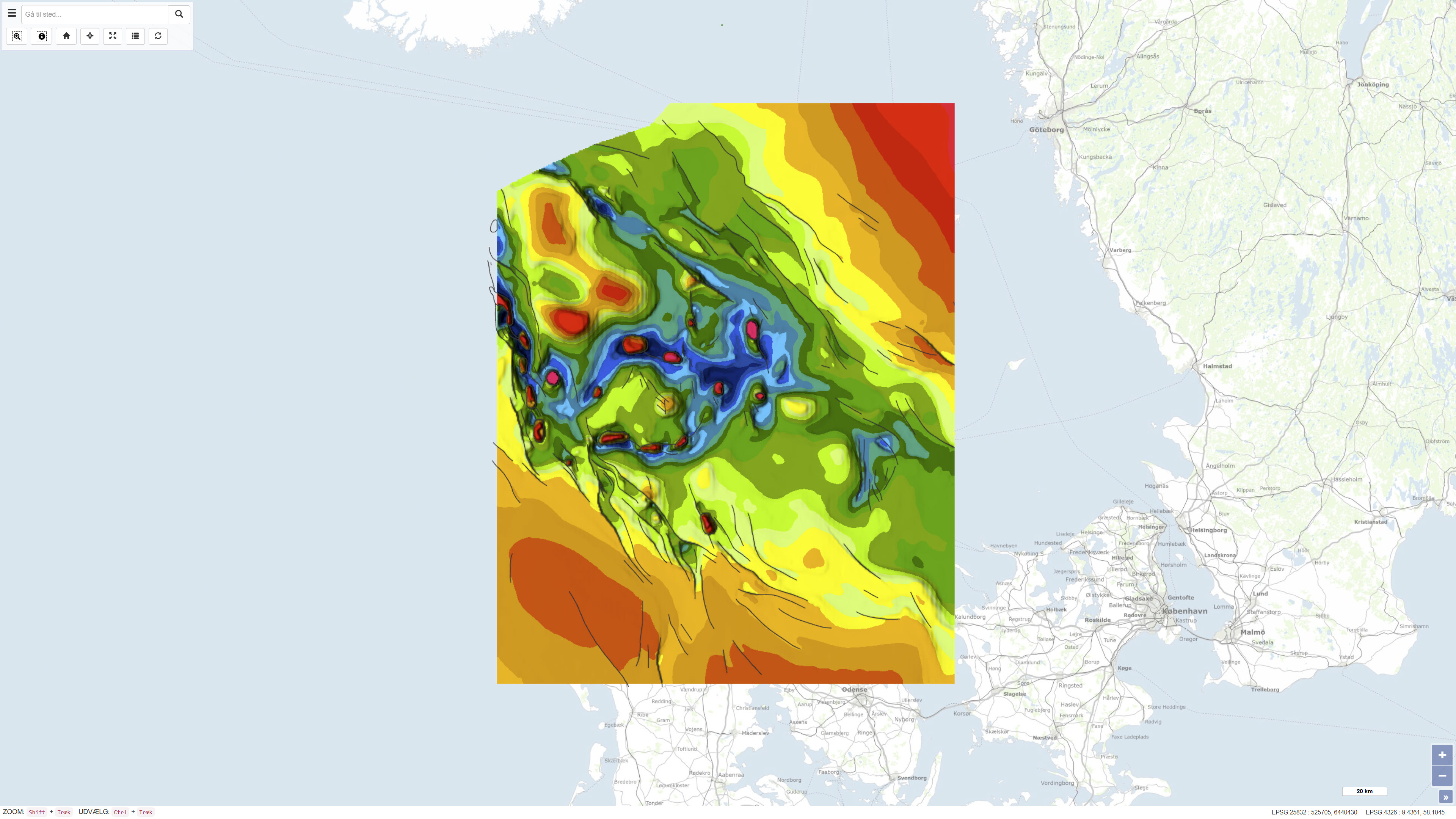
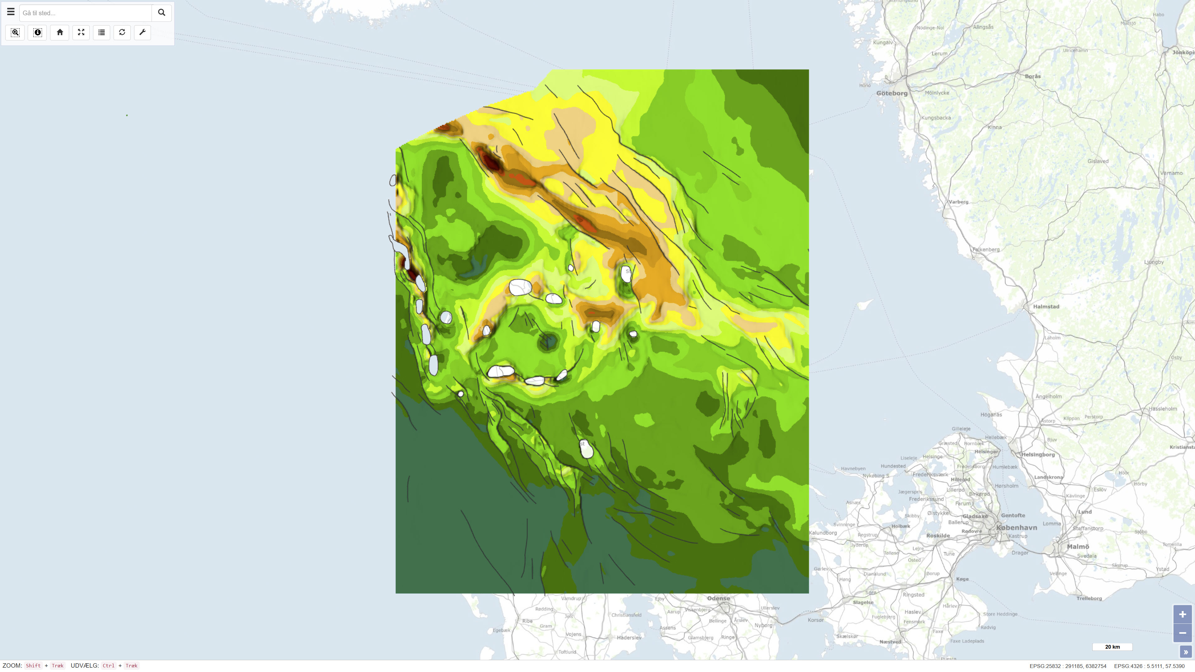
Geological Map of Denmark, 1:400.000 - The Danish Basin: Top Triassic and Jurassic–Lower Cretaceous
Simple
- Date ( Publication )
- 1991-01-01
- Identifier
- dk.geus / dk_danish_basin_top_trias_jurassic_lower_cretaceous
- Presentation form
- Digital map
- Purpose
- The purpose of the dataset is to document and communicate the regional geological framework of the Top Triassic and Jurassic–Lower Cretaceous units within the Danish Basin. The maps provide a basis for understanding the stratigraphy and structural evolution of the basin and are used in geological research, education, and mineral and hydrocarbon-related studies.
- Status
- Completed
- Maintenance and update frequency
- As needed
- Keywords ( Theme )
-
- Dataset
- Top Triassic
- Jurassic
- Lower Cretaceous
- Danish Basin
- Pre-Quaternary geology
- Denmark
- Forskningsemner Forskningsemner ( Theme )
- Geografisk Geografisk ( Place )
- Access constraints
- Other restrictions
- Use constraints
- Other restrictions
- Other constraints
- CC BY-SA 4.0
- Other constraints
- Use of the dataset requires acknowledgement of the Geological Survey of Denmark and Greenland (GEUS) as the data source.
- Spatial representation type
- Vector
- Spatial representation type
- Grid
- Denominator
- 400000
- Metadata language
- Da
- Character set
- UTF8
- Topic category
-
- Geoscientific information
- Elevation
- Begin date
- 1980-01-01
- End date
- 1991-01-01
))
- Supplemental Information
- The dataset represents a regional overview map based on the geological knowledge and data available at the time of publication. The maps were produced for regional stratigraphic and structural analysis and are not intended for detailed local investigations. The dataset is not subject to continuous updates and should be used in conjunction with more recent geological maps, 3D models, and borehole data where more detailed or up-to-date interpretations are required.
- Reference system identifier
- ETRS 89 / UTM 32N (EPSG:25832)
- Distribution format
-
-
WMS
(
)
-
REST
(
)
-
WMS
(
)
- OnLine resource
-
Interactive webmap
(
WWW:LINK-1.0-http--link
)
Interactive map displaying the dataset.
- OnLine resource
-
Geological Map of Denmark, 1:400.000 – The Danish Basin: Top Triassic and Jurassic–Lower Cretaceous
(
DOI
)
Combined publication from DGU Map Series No. 30 containing maps and accompanying descriptions of depth and thickness conditions for the Top Triassic and Jurassic–Lower Cretaceous units in the Danish Basin. Published by the Geological Survey of Denmark in 1991.
- OnLine resource
-
DetDanskeBassin
(
ESRI:REST
)
ArcGIS REST Service
- OnLine resource
-
DB_JuraNedreKridt_iso
(
OGC:WMS-1.3.0-http-get-capabilities
)
ArcGIS WMS Service
- Hierarchy level
- Dataset
- Statement
- The maps were produced by the Geological Survey of Denmark (DGU) based on an integrated assessment of available borehole data, seismic information, previous geological maps, and stratigraphic analyses. The data were compiled and interpreted to produce regional depth and thickness maps of the Top Triassic and Jurassic–Lower Cretaceous units within the Danish Basin. The work represents a synthesis of the best available knowledge at the time of publication and was published in 1991 as part of the DGU Map Series No. 30. The dataset is a historical product and is not subject to continuous updates.
- File identifier
- f98f0682-74ea-4982-9f4f-c5fcce89bf40 XML
- Metadata language
- Danskda
- Character set
- UTF8
- Hierarchy level
- Dataset
- Date stamp
- 2026-03-20T14:17:48.780961Z
- Metadata standard name
- ISO 19115:2003/19139
- Metadata standard version
- 1.0
Overviews
Spatial extent
Provided by
