 Arctic SDI catalogue
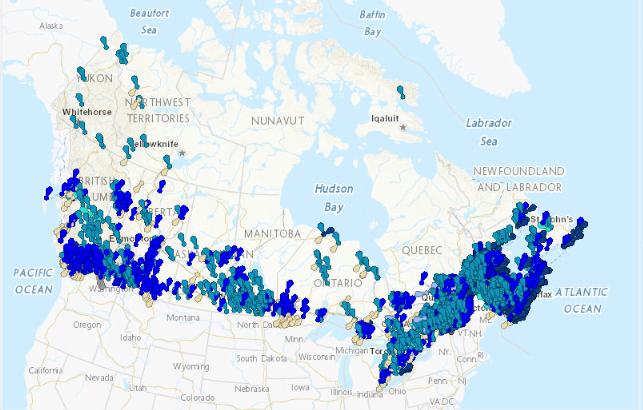
Historical Flood Events (HFE)
Representation of the causes of flooding events in the form of multiple points. The point groupings correspond to the set of locations that were affected by the same event. The inventory of past flooding events was compiled from various public sources and standardized into a common data model. Sources used are included in the data.
Event locations have been extensively revised to have one location per location reported as affected by the flood. Flood events for which no location was included in the sources used are positioned on the place name of the location affected by the flood. The event positions do not indicate where the flooding occurred. Flood events that affected more than one locality are represented by a multipoint.
For each event after January 1, 1980 caused by a heavy rainfall or a coastal storm , a precipitation analysis document, a precipitation animation and the precipitation data are available. These documents are the result of a collaboration with Environment and Climate Change Canada.
Disclaimer:
It should be noted that no consultation was conducted with the various providers and stakeholders of the historic flood data. Disparities in content among the various sources result in an incomlete product. No warranty is given as to the accuracy or completeness of the information provided. The absence of information does not mean that no flooding has occurred.
Simple
- Date ( RI_367 )
- 2025-12-10
- Date ( RI_366 )
- 2021-12-21
- Status
- onGoing; enContinue RI_596
- Maintenance and update frequency
- irregular; irrégulier RI_541
- Keywords ( RI_528 )
-
- EHI
- HFE
- FHIMP
- PICAI
- Flood
- Precipitation
- Historic data
- Government of Canada Core Subject Thesaurus Thésaurus des sujets de base du gouvernement du Canada ( RI_528 )
-
- Oceans
- Water
- Floods
- Environment
- Meteorology
- Use limitation
- Open Government Licence - Canada (http://open.canada.ca/en/open-government-licence-canada)
- Access constraints
- license; licence RI_606
- Use constraints
- license; licence RI_606
- Spatial representation type
- vector; vecteur RI_635
- Metadata language
- eng; CAN
- Metadata language
- fra; CAN
- Character set
- utf8; utf8 RI_458
- Topic category
-
- Inland waters
- Climatology, meteorology, atmosphere
- Environment
- Geoscientific information
- Oceans
- Begin date
- 1696-04-01
- End date
- 2025-07-22
))
- Reference system identifier
- https://www.epsg-registry.org / EPSG:3978 /
- Distribution format
-
-
FGDB/GDB
(
10.3.1
)
-
ESRI REST
(
10.3.1
)
-
WMS
(
1.3.0
)
-
GPKG
(
1.3.1
)
-
FGDB/GDB
(
10.3.1
)
- OnLine resource
-
Historical Flood Events
(
ESRI REST: Map Server
)
Web Service;ESRI REST;fra
- OnLine resource
-
Historical Flood Events
(
HTTPS
)
Web Service;WMS;fra
- OnLine resource
-
Historical Flood Events
(
HTTPS
)
Web Service;WMS;fra
- OnLine resource
-
Historical Flood Events
(
FTP
)
Dataset;FGDB/GDB;eng
- OnLine resource
-
Historical Flood Events
(
FTP
)
Dataset;FGDB/GDB;fra
- OnLine resource
-
Historical Flood Events - Product specifications
(
FTP
)
Supporting Document;PDF;eng
- OnLine resource
-
Historical Flood Events - Product specifications
(
FTP
)
Supporting Document;PDF;fra
- OnLine resource
-
Historical Flood Events
(
FTP
)
Dataset;GPKG;eng
- OnLine resource
-
Historical Flood Events
(
FTP
)
Dataset;GPKG;fra
- OnLine resource
-
Historical Flood Events
(
ESRI REST: Map Server
)
Web Service;ESRI REST;eng
- File identifier
- fe83a604-aa5a-4e46-903c-685f8b0cc33c XML
- Metadata language
- eng; CAN
- Character set
- utf8; utf8 RI_458
- Hierarchy level
- dataset; jeuDonnées RI_622
- Date stamp
- 2025-12-11T11:14:40
- Metadata standard name
- North American Profile of ISO 19115:2003 - Geographic information - Metadata
- Metadata standard version
- CAN/CGSB-171.100-2009
Overviews
Spatial extent
Provided by
