 Arctic SDI catalogue
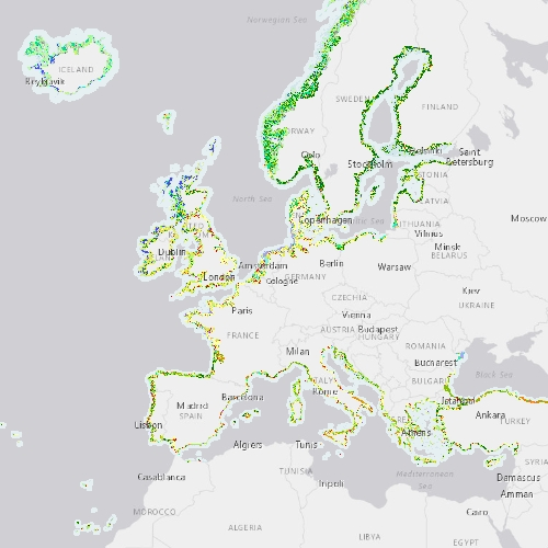
Coastal Zones Land Cover/Land Use 2012 (vector), Europe, 6-yearly, Feb. 2021
The Coastal Zones (CZ) LC/LU product for 2012 is providing a detailed Land Cover / Land Use (LC/ LU) dataset for areas along the coastline of the EEA38 countries and the United Kingdom, with reference year 2012 for the classification. This product monitors landscape dynamics in European coastal territory to an inland depth of 10 km with a total area of approximately 730,000 km², with all the relevant areas (estuaries, coastal lowlands, nature reserves). The production of the coastal zone layers was coordinated by the European Environment Agency (EEA) in the frame of the EU Copernicus programme, as part of the Copernicus Land Monitoring Service (CLMS) Local Component.
The Coastal Zones product covers a buffer zone of coastline derived from EU-Hydro v1.1. Land Cover/Land Use (LC/LU) layer is extracted from Very High Resolution (VHR) satellite data and other available data. The class definitions follow the pre-defined nomenclature on the basis of Mapping and Assessment of Ecosystems and their Services (MAES) typology of ecosystems (Level 1 to Level 4) and CORINE Land Cover adapted to the specific characteristics of coastal zones. The classification provides 71 distinct thematic classes with a Minimum Mapping Unit (MMU) of 0.5 ha and a Minimum Mapping Width (MMW) of 10 m. The product is available for the 2012 and 2018 reference year including change mapping.
This CZ dataset is distributed in vector format, in a single OGC GeoPackage SQLite file covering the area of interest.
Simple
- Date ( Creation )
- 2020-11-12
- Date ( Publication )
- 2020-11-13
- Date ( Revision )
- 2021-02-24
- Edition
- 01.00
- Identifier
- copernicus_v_3035_10_m_cz-2012_p_2010-2014_v01_r00
- Unique resource identifier
- 10.2909/fe8d5d51-36ab-46d4-be61-dcfad7c308f1
- Maintenance and update frequency
- Continual
- GEMET - INSPIRE themes, version 1.0 ( Theme )
-
- Land use
- Hydrography
- Land cover
- Keywords
-
- Continents, countries, sea regions of the world. ( Place )
-
- EEA38 (from 2020)
- United Kingdom
- Keywords
-
- GEMET ( Theme )
-
- hydrography
- coastal area
- landscape alteration
- land cover
- land use
- Spatial scope ( Theme )
- EEA topics ( Theme )
-
- Land use
- Access constraints
- Other restrictions
- Other constraints
- no limitations to public access
- Use constraints
- Other restrictions
- Other constraints
-
The Copernicus component is governed by Regulation (EU) No 2021/696 of the European Parliament and of the Council of 28 April 2021 establishing the Union Space Programme and the European Union Agency for the Space Programme and repealing Regulations (EU) No 912/2010, (EU) No 1285/2013 and (EU) No 377/2014 and Decision No 541/2014/EU. Within the Copernicus component, a portfolio of land monitoring activities has been delegated by the European Union to the European Environment Agency (EEA) and the DG Joint Research Centre of the European Commission.
The Copernicus land monitoring products and services are made available on a principle of full, open and free access, as established by the Commission Delegated Regulation (EU) No 1159/2013 of 12 July 2013.
Free, full and open access to the products and services of the Copernicus Land Monitoring Service is made on the conditions that:
1. When distributing or communicating Copernicus Land Monitoring Service products and services (data, software scripts, web services, user and methodological documentation and similar) to the public, users shall inform the public of the source of these products and services.
2. Where the Copernicus Land Monitoring Service products and services have been adapted or modified by the user, the user shall clearly state this.
3. Users shall make sure not to convey the impression to the public that the user's activities are officially endorsed by the European Union.
- Spatial representation type
- vector Vector
- Distance
- 10 m
- Denominator
- 10000
- Metadata language
- en
- Character set
- utf8 UTF8
- Topic category
-
- Environment
- Imagery base maps earth cover
- Begin date
- 2010-01-01
- End date
- 2014-12-31
))
- Supplemental Information
- Spatial Resolution information: The Minimum Mapping Width is 10 m
- Unique resource identifier
- EPSG:3035
- Distribution format
-
-
Geopackage
(
)
-
Geopackage
(
)
- OnLine resource
-
CLMS Website
(
WWW:DOWNLOAD
)
Download (requires authentication)
- OnLine resource
-
Coastal_Zones_2012_vector53031
(
OGC:WMS
)
Coastal Zones 2012 vector
- OnLine resource
- https://doi.org/10.2909/fe8d5d51-36ab-46d4-be61-dcfad7c308f1 ( DOI )
- OnLine resource
- Product Information & Technical Documentation ( WWW:LINK )
- OnLine resource
- https://image.discomap.eea.europa.eu/arcgis/rest/services/CoastalZones/CZ_CoastalZones_2012/MapServer ( ESRI:REST )
- Hierarchy level
- Dataset
Conformance result
- Date ( Publication )
- 2010-12-08
- Explanation
- See the referenced specification
- Statement
-
Computer assisted visual mapping of LC/LU for reference year 2012. The main dataset for visual image interpretation of reference year 2012 was the DWH_MG2b_CORE_03 dataset (Optical VHR2 coverage over EU 2011-2013), mainly consisting of 1.5m VHR2 SPOT-6 and 2.5m VHR2 SPOT-5 HRG and 2m Pléiades satellite data. The nomenclature is the basis of the MAES typology of ecosystems adapted to the specific needs of coastal zones monitoring and it is composed by 71 classes.
Positional Accuracy: less than 5 m (according to geo-location accuracy of satellite imagery delivered by ESA: less than 5m RMSE). Thematic accuracy (area-corrected Overall Accuracy): 97.9%. Accuracy Assessment approach: Stratified Random Point Sampling with 60001 sampling points. Interpretation of sampling points has been performed on the best available reference data.
The Minimum Mapping Unit is 0.5 ha.
The Minimum Mapping Width is 10 m.
- File identifier
- fe8d5d51-36ab-46d4-be61-dcfad7c308f1 XML
- Metadata language
- en
- Character set
- UTF8
- Hierarchy level
- Dataset
- Date stamp
- 2025-10-09T11:25:35.908513Z
- Metadata standard name
- ISO 19115/19139
- Metadata standard version
- 1.0
Overviews
Spatial extent
Provided by
