 Arctic SDI catalogue
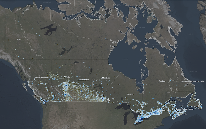
National Human Settlement - Physical Exposure
The Physical Exposure component of the National Human Settlement Layer (NHSL), defined here as the ‘Physical Exposure Model’, includes a delineation of settled areas and related land use across Canada, as well as information about buildings, persons, and building replacement values (structure and contents) within those areas.
Buildings within the inventory are classified using a combination of occupancy types, engineering-based construction types adopted for Canada, and design levels representing the approximate building code requirements at the time of construction. The inventory is derived from detailed housing statistics provided at the dissemination area level as part of the 2016 national census and from georeferenced business listings. Building populations at different times of day are estimated for standard daytime hours (9am-5pm); for morning and evening commute hours (7am-9am; 5pm-7pm), and; for nighttime hours when the majority of people are home (7pm-7am). Replacement values are provided for structural, nonstructural, and contents components of buildings, based on industry replacement costs for representative regions across Canada.
The physical exposure model is provided in two formats: (1) According to settled areas (i.e., polygons), which are areas that approximately delineate clusters of buildings across Canada. Summary statistics about buildings and populations within each settled area boundary are provided. (2) According to building archetypes (i.e., points) within settled areas. These are represented as point locations at the centroid of the corresponding settled area, and each settled area can have multiple point features corresponding to different building archetypes present within that area.
In total, the model characterizes 35.2 million people in 9.7 million buildings across 390,000 locations with a total approximate replacement value of $8.2 trillion (2019 CAD) including contents.
Simple
- Date ( RI_366 )
- 2020-06-15
- Date ( RI_367 )
- 2020-11-15
- Status
- onGoing; enContinue RI_596
- Maintenance and update frequency
- asNeeded; auBesoin RI_540
- Government of Canada Core Subject Thesaurus Thésaurus des sujets de base du gouvernement du Canada ( RI_528 )
-
- Land management
- Planning
- Sustainable development
- Use limitation
- Open Government Licence - Canada (http://open.canada.ca/en/open-government-licence-canada)
- Access constraints
- license; licence RI_606
- Use constraints
- license; licence RI_606
- Spatial representation type
- vector; vecteur RI_635
- Metadata language
- eng; CAN
- Topic category
-
- Society
- Begin date
- 2016
- End date
- 2021
))
- Reference system identifier
- http://www.epsg-registry.org / EPSG:4326 /
- Distribution format
-
-
GPKG
(
1.2
)
-
ESRI REST
(
10.71
)
-
WMS
(
1.3.0
)
-
GPKG
(
1.2
)
- OnLine resource
-
NHSL Physical Exposure (Settlement Area)
(
HTTPS
)
Dataset;GPKG;eng,fra
- OnLine resource
-
NHSL Physical Exposure
(
ESRI REST: Map Server
)
Web Service;ESRI REST;eng
- OnLine resource
-
NHSL Physical Exposure
(
ESRI REST: Map Server
)
Web Service;ESRI REST;fra
- OnLine resource
-
NHSL Physical Exposure
(
OGC:WMS
)
Web Service;WMS;eng
- OnLine resource
-
NHSL Physical Exposure
(
OGC:WMS
)
Web Service;WMS;fra
- OnLine resource
-
NHSL Physical Exposure (Buildings)
(
HTTPS
)
Dataset;GPKG;eng,fra
- OnLine resource
-
Data Dictionary
(
HTTPS
)
Supporting Document;XLSX;eng
- OnLine resource
-
Data Dictionary
(
HTTPS
)
Supporting Document;XLSX;fra
- OnLine resource
-
GitHub Repository
(
HTTPS
)
Supporting Document;HTML;eng
- OnLine resource
-
Geological Survey of Canada Open File
(
HTTPS
)
Supporting Document;ZIP;eng
- File identifier
- 1818cf27-03ea-4ebb-bc43-fd371b42198b XML
- Metadata language
- eng; CAN
- Character set
- utf8; utf8 RI_458
- Parent identifier
- Human Settlement and Natural Hazards in Canada e9905001-6a39-43ca-a02d-4ab5144df0f8
- Hierarchy level
- dataset; jeuDonnées RI_622
- Date stamp
- 2022-08-26T16:02:57
- Metadata standard name
- North American Profile of ISO 19115:2003 - Geographic information - Metadata
- Metadata standard version
- CAN/CGSB-171.100-2009
Overviews
Spatial extent
Provided by
