 Arctic SDI catalogue
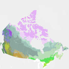
Vegetation Zones of Canada: a Biogeoclimatic Perspective
"Vegetation Zones of Canada: a Biogeoclimatic Perspective" maps Canadian geography in relation to gradients of regional climate, as expressed by potential vegetation on zonal sites. Compared to previous similar national-scale products, "Vegetation Zones of Canada" benefits from the work of provincial and territorial ecological classification programs over the last 30+ years, incorporating this regional knowledge of ecologically significant climatic gradients into a harmonized national map. This new map, reflecting vegetation and soils adapted to climates prior to approximately 1960, can serve as a broad-scale (approximately 1:5 M to 1:10 M) geospatial reference for monitoring and modeling effects of climate changes on Canadian ecosystems.
"Vegetation Zones of Canada: a Biogeoclimatic Perspective" employs a two-level hierarchical legend. Level 1 vegetation zones reflect the global-scale latitudinal gradient of annual net radiation, as well as the effects of high elevation and west to east climatic and biogeographic variation across Canada. Within the level 1 vegetation zones, level 2 zones distinguish finer scale variation in zonal vegetation, especially in response to elevational and arctic climatic gradients, climate-related floristics and physiognomic diversity in the Great Plains, and maritime climatic influences on the east and west coasts.
Thirty-three level 2 vegetation zones are recognized:
High Arctic Sparse Tundra
Mid-Arctic Dwarf Shrub Tundra
Low Arctic Shrub Tundra
Subarctic Alpine Tundra
Western Boreal Alpine Tundra
Cordilleran Alpine Tundra
Pacific Alpine Tundra
Eastern Alpine Tundra
Subarctic Woodland-Tundra
Northern Boreal Woodland
Northwestern Boreal Forest
West-Central Boreal Forest
Eastern Boreal Forest
Atlantic Maritime Heathland
Pacific Maritime Rainforest
Pacific Dry Forest
Pacific Montane Forest
Cordilleran Subboreal Forest
Cordilleran Montane Forest
Cordilleran Rainforest
Cordilleran Dry Forest
Eastern Temperate Mixed Forest
Eastern Temperate Deciduous Forest
Acadian Temperate Forest
Rocky Mountains Foothills Parkland
Great Plains Parkland
Intermontane Shrub-Steppe
Rocky Mountains Foothills Fescue Grassland
Great Plains Fescue Grassland
Great Plains Mixedgrass Grassland
Central Tallgrass Grassland
Cypress Hills
Glaciers
Please cite this dataset as: Baldwin, K.; Allen, L.; Basquill, S.; Chapman, K.; Downing, D.; Flynn, N.; MacKenzie, W.; Major, M.; Meades, W.; Meidinger, D.; Morneau, C.; Saucier, J-P.; Thorpe, J.; Uhlig, P. 2019. Vegetation Zones of Canada: a Biogeoclimatic Perspective. [Map] Scale 1:5,000,000. Natural Resources Canada, Canadian Forest Service. Great Lake Forestry Center, Sault Ste. Marie, ON, Canada.
Simple
- Date ( RI_367 )
- 2020-03-05
- Date ( RI_366 )
- 2018-01
- Status
- completed; complété RI_593
- Maintenance and update frequency
- asNeeded; auBesoin RI_540
- Keywords ( RI_524 )
-
- bioclimate, ecoclimatic regions, vegetation, biome, zone
- Government of Canada Core Subject Thesaurus Thésaurus des sujets de base du gouvernement du Canada ( RI_528 )
-
- Ecosystems
- Forests
- Glaciers
- Natural history
- Ecology
- Arctic ecosystems
- Biology
- Boreal ecosystems
- Plants
- Polar regions
- Terrestrial ecosystems
- Grasslands
- Climate
- Environment
- Use limitation
- Open Government Licence - Canada (http://open.canada.ca/en/open-government-licence-canada)
- Access constraints
- license; licence RI_606
- Use constraints
- otherRestrictions; autresRestrictions RI_609
- Other constraints
-
Yukon – BC border discontinuities: There are vegetation zone discontinuities at the political border between Yukon and British Columbia. These are known artifacts that represent differences between vegetation zone equivalents in each jurisdiction. The Vegetation Zones of Canada product is a synthesis of existing provincial & territorial jurisdictional treatments. We have worked with our provincial/territorial partners to harmonize their eco-regionalizations across borders where possible, but this was not possible here because the 2 jurisdictional products were at different stages of development.
The Cordilleran Alpine Tundra polygon that follows the BC - Alberta border south of approximately Grande Cache, AB is an error and over-represents the area of alpine tundra in this part of the Rocky Mountains.
- Spatial representation type
- vector; vecteur RI_635
- Metadata language
- eng
- Metadata language
- fra
- Character set
- utf8; utf8 RI_458
- Topic category
-
- Biota
- Environment
- Begin date
- 1977-07
))
- Reference system identifier
- http://www.epsg-registry.org / EPSG:3978 /
- Distribution format
-
-
FGDB/GDB
(
10.4.1
)
-
SHP
(
10.4.1
)
-
GPKG
(
1.2
)
-
FGDB/GDB
(
10.4.1
)
- OnLine resource
-
Feature table dictionary
(
HTTPS
)
Supporting Document;CSV;eng,fra
- OnLine resource
-
Vegetation Zones of Canada: a Biogeoclimatic Perspective (Information Report GLC-X-25)
(
HTTPS
)
Supporting Document;HTML;eng
- OnLine resource
-
Zones de végétation du Canada: une perspective biogéoclimatique (Rapport d'information GLC-X-25F).
(
HTTPS
)
Supporting Document;HTML;fra
- OnLine resource
-
Vegetation Zones of Canada
(
ESRI REST: Map Server
)
Web Service;ESRI REST;eng
- OnLine resource
-
Vegetation Zones of Canada
(
ESRI REST: Map Server
)
Web Service;ESRI REST;fra
- OnLine resource
-
Vegetation Zones of Canada
(
HTTPS
)
Dataset;FGDB/GDB;eng,fra
- OnLine resource
-
Vegetation Zones of Canada
(
HTTPS
)
Dataset;GPKG;eng,fra
- OnLine resource
-
Vegetation Zones of Canada
(
HTTPS
)
Dataset;SHP;eng,fra
- OnLine resource
-
Vegetation Zones of Canada
(
OGC:WMS
)
Web Service;WMS;eng
- OnLine resource
-
Vegetation Zones of Canada
(
OGC:WMS
)
Web Service;WMS;fra
- File identifier
- 22b0166b-9db3-46b7-9baf-6584a3acc7b1 XML
- Metadata language
- eng; CAN
- Character set
- utf8; utf8 RI_458
- Hierarchy level
- dataset; jeuDonnées RI_622
- Date stamp
- 2021-11-29T20:24:52
- Metadata standard name
- North American Profile of ISO 19115:2003 - Geographic information - Metadata
- Metadata standard version
- CAN/CGSB-171.100-2009
Overviews


Spatial extent
Provided by
