 Arctic SDI catalogue
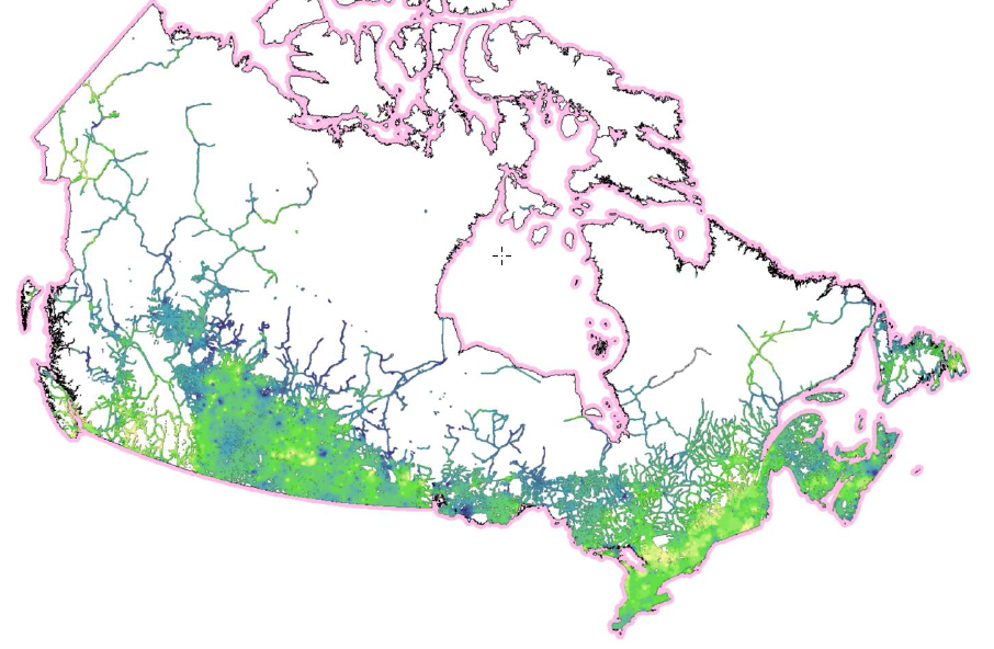
Regional and Community Vitality Index
The RVI/CVI database is derived from the CanEcumene 3.0 GDB (Eddy, et. al. 2023) using a selection of socio-economic variables identified in Eddy and Dort (2011) that aim to capture the overall state of socio-economic conditions of communities as ‘human habitats’. This dataset was developed primarily for application in mapping socio-economic conditions of communities and regions for environmental and natural resource management, climate change adaptation, Impact Assessments (IAs) and Regional Assessments (RAs), and Cumulative Effects Assessment (CEA).
The RVI/CVI is comprised of five sub-indicators: 1) population change, 2) age structure, 3) education levels, 4) employment levels, and 5) real estate values. Index values are based on percentile ranks of each sub-indicator, and averaged for each community, and for three ranked groups: 1) all of Canada, 2) by province, and 3) by population size. The data covers the Census periods of 2001, 2006, 2011 (NHS), 2016, and 2021.
The index is mapped in two ways: 1) as ‘points’ for individual communities (CVI), and 2) as ‘rasters’ for spatial interpolation of point data (RVI). These formats provide an alternative spatial framework to conventional StatsCan CSD framework. (For more information on this approach see Eddy, et. al. 2020).
============================================================================================
Eddy, B.G., Muggridge, M., LeBlanc, R., Osmond, J., Kean, C., and Boyd, E. 2023. The CanEcumene 3.0 GIS Database. Federal Geospatial Platform (FGP), Natural Resources Canada. https://gcgeo.gc.ca/viz/index-en.html?keys=draft-3f599fcb-8d77-4dbb-8b1e-d3f27f932a4b
Eddy B.G., Muggridge M, LeBlanc R, Osmond J, Kean C, Boyd E. 2020. An Ecological Approach for Mapping Socio-Economic Data in Support of Ecosystems Analysis: Examples in Mapping Canada’s Forest Ecumene. One Ecosystem 5: e55881. https://doi.org/10.3897/oneeco.5.e55881
Eddy, B.G.; Dort, A. 2011. Integrating Socio-Economic Data for Integrated Land Management (ILM): Examples from the Humber River Basin, western Newfoundland. Geomatica, Vol. 65, No. 3, p. 283-291. doi:10.5623/cig2011-044.
Simple
- Date ( RI_367 )
- 2020
- Date ( RI_366 )
- 2016
- Status
- onGoing; enContinue RI_596
- Maintenance and update frequency
- asNeeded; auBesoin RI_540
- Keywords ( RI_525 )
-
- community vitality, community resilience, adaptive capacity, ecumene, populated places, indigenous communities, census, socio-economic, demographic, ecosystems
- Government of Canada Core Subject Thesaurus Thésaurus des sujets de base du gouvernement du Canada ( RI_528 )
-
- Census data
- Ecosystems
- Socioeconomic data
- Demographic maps
- Population
- Population distribution
- Indigenous peoples
- Demographic data
- Use limitation
- Open Government Licence - Canada (http://open.canada.ca/en/open-government-licence-canada)
- Access constraints
- license; licence RI_606
- Use constraints
- license; licence RI_606
- Spatial representation type
- vector; vecteur RI_635
- Metadata language
- eng
- Metadata language
- fra
- Topic category
-
- Environment
- Begin date
- 2001
- End date
- 2023
))
- Reference system identifier
- http://www.epsg-registry.org / EPSG:3978 /
- Reference system identifier
- http://www.epsg-registry.org / EPSG:3347 /
- Distribution format
-
-
SHP
(
unknown
)
-
ESRI REST
(
10.3.1
)
-
FGDB/GDB
(
10
)
-
SHP
(
unknown
)
- OnLine resource
-
Regional and Community Vitality Index - MXD EN
(
HTTPS
)
Supporting Document;MXD;eng
- OnLine resource
-
Regional and Community Vitality Index - Raster Files
(
HTTPS
)
Dataset;TIFF;zxx
- OnLine resource
-
Regional and Community Vitality Index - Shapefiles
(
HTTPS
)
Dataset;SHP;eng
- OnLine resource
-
Regional and Community Vitality Index - GDB
(
HTTPS
)
Dataset;FGDB/GDB;eng
- OnLine resource
-
Regional and Community Vitality Index - Excel Files
(
HTTPS
)
Dataset;XLS;eng
- OnLine resource
-
Regional and Community Vitality Index - WMS EN
(
HTTPS
)
Web Service;WMS;eng
- OnLine resource
-
Regional and Community Vitality Index
(
ESRI REST: Map Server
)
Web Service;ESRI REST;fra
- OnLine resource
-
Regional and Community Vitality Index - WMS FR
(
HTTPS
)
Web Service;WMS;fra
- OnLine resource
-
Regional and Community Vitality Index - Time Series
(
HTTPS
)
Application;HTML;fra
- OnLine resource
-
Regional and Community Vitality Index - Time Series
(
HTTPS
)
Application;HTML;eng
- OnLine resource
-
Regional and Community Vitality Index - Technical Reference V2 (English)
(
HTTPS
)
Supporting Document;PDF;eng
- OnLine resource
-
02. Document de référence technique Vers. 3.0 - FR
(
HTTPS
)
Supporting Document;PDF;fra
- OnLine resource
-
Regional and Community Vitality Index
(
ESRI REST: Map Server
)
Web Service;ESRI REST;eng
- File identifier
- 461123f1-1370-4709-aeda-639783ee8455 XML
- Metadata language
- eng; CAN
- Character set
- utf8; utf8 RI_458
- Parent identifier
- The Canadian Ecumene (CanEcumene) 3.0 GIS Database 3f599fcb-8d77-4dbb-8b1e-d3f27f932a4b
- Hierarchy level
- dataset; jeuDonnées RI_622
- Date stamp
- 2025-02-13T10:11:03
- Metadata standard name
- North American Profile of ISO 19115:2003 - Geographic information - Metadata
- Metadata standard version
- CAN/CGSB-171.100-2009
Overviews
Spatial extent
Provided by
