 Arctic SDI catalogue
SCANFI v3: Pan-Canadian annual fractional landcover at 30-m resolution (1985–2025)
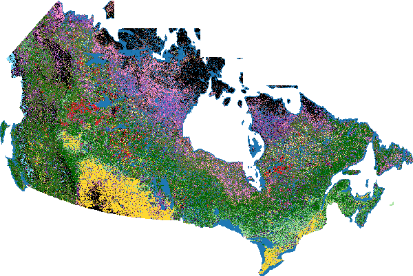
This data publication contains a set of 30-m resolution raster files representing annual (1985–2025) wall-to-wall maps of fractional landcover across Canada originally described in (Guindon et al., 2026a). The dataset provides pixel-level percentage estimates of water, rock, soil, burn scars, lichen, herbaceous vegetation, low shrubs, and tall shrubs, as well as broadleaf and coniferous treed crown closure layers derived from SCANFI v2. A summary discrete landcover classification layer is also provided. The Spatialized CAnadian National Forest Inventory (SCANFI) version 3 extends the existing SCANFI framework to include both treed and non-treed surface components, enabling a comprehensive vertical surface projection where all fractional cover components within each 30-m pixel sum to 100%.
**Relationship with SCANFI v2**
SCANFI v3 is fully harmonized with the SCANFI v2 dataset (Guindon et al., 2026b) https://doi.org/10.23687/07653869-f303-46c2-a04e-9ab479b73cbf ). Coniferous and broadleaf treed crown closure values are extracted directly from SCANFI v2, ensuring consistency across treed structural and species attributes. The novel non-treed fractional cover layers introduced in SCANFI v3 are designed to be compatible with existing SCANFI v2 layers (canopy height, aboveground biomass, tree species composition), extending the product's utility without replacing previous outputs.
**Methodology overview**
The methodology, along with exhaustive validation analyses, are described in detail in the official publication (Guindon et al., 2026a).
**Landcover classification methodology**
- Non-vegetated pixels (water, rock, soil, burn scars) were classified by the cover type with the highest fractional proportion.
- Non-treed vegetation was split into shrub and non-shrub (herbaceous/lichen) classes, based on the highest fractional proportion.
- Shrub pixels were further classified as low or tall shrub, based on the highest fractional proportion.
- Treed pixels were classified as coniferous or broadleaf if crown closure exceeded 75%, otherwise as mixed.
- Non-treed pixels with 10-50% coniferous crown closure were reclassified as "treed coniferous," noting the dominant ground cover (e.g., treed coniferous with lichen).
**Validation summary**
- Treed cover (from SCANFI v2):
- Internal leave-one-plot-out validation: overall crown closure R² = 0.82, RMSE = 13.95; broadleaf cover R² = 0.70, RMSE = 19.82.
- External validation of crown closure with ABoVE airborne lidar: R² = 0.73, RMSE = 28.55.
- Additional external validation with 48,255 MAGPlots: broadleaf R² = 0.77, RMSE = 18.38; coniferous R² = 0.75, RMSE = 19.36.
- Water cover:
- Landsat random forest classifier (detection of mixed water pixels): accuracy = 93%, Kappa = 0.89.
- XGBoost regression for continuous water cover: R² = 0.92, RMSE = 12.01, MAE = 5.48 (all pixels); R² = 0.48, RMSE = 17.68, MAE = 11.38 (mixed water pixels only).
- Landsat non-treed fractional cover (30-m): Stratified leave-one-plot-out cross-validation R² ranged from 0.22 (low shrubs) to 0.58 (treed broadleaf). Intermediate performance for herbaceous, lichen, and burn scars (R² = 0.55).
- External validation:
- Comparison with the Quebec northern ecological map (n = 1,242,423 polygons) showed overall agreement across landcover strata.
- NASA ABoVE lidar vertical profiles were consistent with predicted landcover classes.
- Field validation (342 plots across five provinces and territories) confirmed internal metrics for rock, soil, lichen, and low shrubs, with improved treed class accuracy (broadleaf R² = 0.65; coniferous R² = 0.69).
**Dataset description**
Annual (1985–2025) fractional landcover is represented as single-band GeoTIFF files with the following naming convention:
SCANFI_XXX_YYY_ZZZ_[version_number]_[YYYYMMDD].tif, where:
- XXX = landcover type:
- nonTreed for all novel non-treed landcover classes introduced in this study
- treed for SCANFI treed species crown closure
- landcover for the summary discrete landcover layer
- YYY = fractional component class: water, rock, soil, burnScars, lichen, herbaceous, lowShrubs, tallShrubs, broadleaf, or coniferous
- ZZZ = target year: 1985 onwards
- version_number = v3
- YYYYMMDD = date of file creation, provided for update tracking
All GeoTIFF files are Cloud Optimized GeoTIFFs (COGs). Pixel values (except for the landcover layer) represent the percentage of the corresponding class, ranging from 0 to 100. The SCANFI_landcover GeoTIFF files contain integer codes that identify different landcover types. The codes are as follows:
1,Water
2,Rock
3,Soil
4,Burn scars
5,Lichen
6,Herbaceous
7,Low shrubs
8,Tall shrubs
9,Treed broadleaf
10,Treed mixed
11,Treed coniferous
12,Treed coniferous with lichen
13,Treed coniferous with rock/soil
14,Treed coniferous with herbs
15,Treed coniferous with low shrubland
16,Treed coniferous with tall shrubland
17,Cropland
18,Urban
19,Road
20,Snow/Ice
**Data download**
The data can be downloaded from the FTP server on the Open Data portal presented here, preferably using a browser download manager or an external client such as FileZilla. The data will also be available as Cloud Optimized GeoTiffs (COGs) on the Canada Centre for Mapping and Earth Observation Data Cube Platform (https://datacube.services.geo.ca/en/index.html) and on the Laurentian Forestry Center Remote Sensing lab’s Google Earth Engine data catalog (https://developers.google.com/earth-engine/datasets/publisher/gcpm041u-lemur?hl=en).
**Known limitations and usage notes**
**1.** Wetland environments remain particularly challenging to map, as exposed wet soils or mud surfaces may occasionally be confused with rock or bare soil.
**2.** The separation between tall shrubs (>1 m) and young deciduous broadleaf stands can be difficult in regenerating forests, where structural and spectral differences are gradual. This can also be challenging in northern areas with low productivity.
**3.** Lichen cover may still be predicted along small roads, trails, or disturbed surfaces not identified in the Statistics Canada or OpenStreetMap masks, as well as within some unmapped urban areas.
**4.** Some regions of Yukon remain challenging, as previously reported in SCANFI v1 (Guindon et al. 2024). These errors are mainly related to limitations in the NFI training dataset available for these remote northern environments. Future NFI photo acquisitions are expected to address this issue.
**5.** Understory predictions are expected to be more reliable in open stands than in dense forested environments.
**6.** The lichen layer represents the vertical fractional presence of lichen cover and should not be interpreted directly as lichen biomass, as factors such as lichen thickness are not explicitly represented.
**7.** The product is based on a vertical land-surface projection approach, representing what optical satellite sensors observe from above. Vegetation located beneath dense forest canopies cannot be directly mapped. However, where local field plot data are available, the fractional layers may serve as predictors for deriving additional site-specific ecosystem attributes (e.g. moss cover).
**8.** In tall and dense forested areas, ground observations remain limited and the near-vertical Landsat observation geometry reduces sensitivity to understory conditions. This dataset was primarily designed for open northern environments and post-disturbance landscapes.
**Mapping information**
- projection: epsg 3979
- resolution: 30m
**License**
The data are licensed under the Creative Commons Attribution 4.0 International license (CC BY 4.0).
**Dataset citation**
- Guindon, L., Correia, D.L.P., Gahrouei, O.R., Perbet, P., Manka, F., Villemaire, P. and Lacarte, S. 2026. SCANFI v3: Canadian fractional landcover maps from 1985 onward. Natural Resources Canada, Canadian Forest Service, Laurentian Forestry Centre, Quebec, Canada. https://doi.org/10.23687/50f132f9-f312-4951-bb9f-9ea99580f29f
**References**
- Guindon, L., Correia, D.L.P., Gahrouei, O.R., Perbet, P., Smiley, B., Stralberg, D., Collins, L., Parisien, M.-A., Wang, X., Manka, F. and Boucher, J. 2026a. Canadian fractional landcover maps from 1985 onward. Scientific Data [In press]
- Guindon, L., Correia, D.L.P., Manka, F., and Smiley, B. 2026b. SCANFI v2: Spatialized CAnadian National Forest Inventory data product v2. Natural Resources Canada. https://doi.org/10.23687/07653869-f303-46c2-a04e-9ab479b73cbf
- Guindon, L., Manka, F., Correia, D.L.P., Villemaire, P., Smiley, B., Bernier, P., Gauthier, S., Beaudoin, A., Boucher, J., and Boulanger, Y. 2024. A new approach for spatializing the CAnadian National Forest Inventory (SCANFI) using Landsat dense time series. Canadian Journal of Forest Research. https://doi.org/10.1139/cjfr-2023-0118
Simple
- Date ( RI_367 )
- 2026
- Date ( RI_366 )
- 2025
- Status
- completed; complété RI_593
- Maintenance and update frequency
- annually; annuel RI_539
- Government of Canada Core Subject Thesaurus Thésaurus des sujets de base du gouvernement du Canada ( RI_528 )
-
- Remote sensing
- Biomass
- Trees
- Forests
- Use limitation
- Open Government Licence - Canada (http://open.canada.ca/en/open-government-licence-canada)
- Access constraints
- license; licence RI_606
- Use constraints
- license; licence RI_606
- Spatial representation type
- grid; grille RI_636
- Metadata language
- eng; CAN
- Character set
- utf8; utf8 RI_458
- Topic category
-
- Geoscientific information
- Imagery base maps earth cover
- Environment
))
- Begin date
- 1984
- End date
- 2025
- Reference system identifier
- http://www.epsg-registry.org / EPSG:3979 / 3
- Distribution format
-
-
GeoTIF
(
unknown
)
-
GeoTIF
(
unknown
)
- OnLine resource
-
ftp download - scanfi v3
(
FTP
)
Dataset;TIFF;zxx
- OnLine resource
-
https download - scanfi v3
(
HTTPS
)
Dataset;TIFF;zxx
- File identifier
- 50f132f9-f312-4951-bb9f-9ea99580f29f XML
- Metadata language
- eng; CAN
- Character set
- utf8; utf8 RI_458
- Parent identifier
- SCANFI v2: the Spatialized CAnadian National Forest Inventory data product 07653869-f303-46c2-a04e-9ab479b73cbf
- Hierarchy level
- dataset; jeuDonnées RI_622
- Date stamp
- 2026-09-03T10:12:18
- Metadata standard name
- North American Profile of ISO 19115:2003 - Geographic information - Metadata
- Metadata standard version
- CAN/CGSB-171.100-2009
Overviews
Spatial extent
Provided by
