 Arctic SDI catalogue
40 Class - Canadian Ecological Domain Classification from Satellite Data.
Simple
- Date ( RI_367 )
- 2009
- Date ( RI_366 )
- 2009
(250) 363-6004
https://cfs.nrcan.gc.ca/employes/vue/mwulder
- Hours of service
- email only please
- Status
- onGoing; enContinue RI_596
- Maintenance and update frequency
- asNeeded; auBesoin RI_540
- Government of Canada Core Subject Thesaurus Thésaurus des sujets de base du gouvernement du Canada ( RI_528 )
-
- Forests
- Use limitation
- Open Government Licence - Canada (http://open.canada.ca/en/open-government-licence-canada)
- Access constraints
- otherRestrictions; autresRestrictions RI_609
- Use constraints
- intellectualPropertyRights; droitsPropriétéIntellectuelle RI_607
- Other constraints
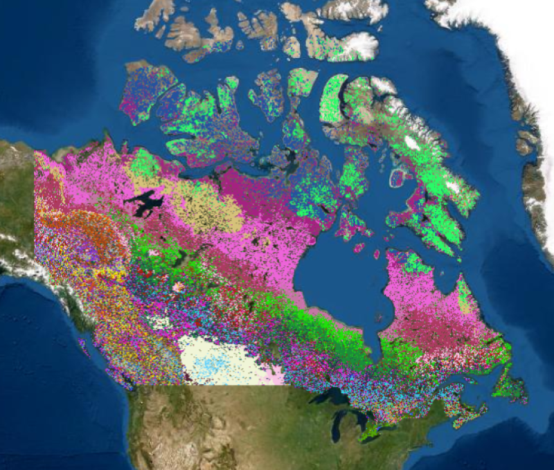
- 40 Class - Canadian Ecological Domain Classification from Satellite Data. Satellite derived data including 1) topography, 2) landscape productivity based on photosynthetic activity, and 3) land cover were used as inputs to create an environmental regionalization of the over 10 million km2 of Canada’s terrestrial land base. The outcomes of this clustering consists of three main outputs. An initial clustering of 100 classes was generated using a two-stage multivariate classification process. Next, an agglomerative hierarchy using a log-likelihood distance measure was applied to create a 40 and then a 14 class regionalization, aimed to meaningfully group ecologically similar components of Canada's terrestrial landscape. For more information (including a graphical illustration of the cluster hierarchy) and to cite this data please use: Coops, N.C., Wulder, M.A., Iwanicka, D. 2009. An environmental domain classification of Canada using earth observation data for biodiversity assessment. Ecological Informatics, Vol. 4, No. 1, Pp. 8-22, DOI: https://doi.org/10.1016/j.ecoinf.2008.09.005. ( Coops et al. 2009).
- Spatial representation type
- grid; grille RI_636
- Metadata language
- eng
- Topic category
-
- Geoscientific information
- Begin date
- 2000
- End date
- 2005
))
- Reference system identifier
- http://www.epsg-registry.org / EPSG:3978 / 1.0
- Distribution format
-
-
GeoTIF
(
1.0
)
-
GeoTIF
(
1.0
)
(250) 363-6004
https://ca.nfis.org/index_eng.html
- Hours of service
- email only please
- OnLine resource
-
Satellite Forest Information for Canada (English)
(
HTTPS
)
Application;HTML;eng
- OnLine resource
-
Satellite Forest Information for Canada (French)
(
HTTPS
)
Application;HTML;fra
- OnLine resource
-
CA_EcoDom_40Class
(
OGC:WMS
)
Web Service;WMS;fra
- OnLine resource
-
CA_EcozoneDomain.zip
(
HTTPS
)
Dataset;ZIP;zxx
- OnLine resource
-
CA_EcoDom_40Class
(
OGC:WMS
)
Web Service;WMS;eng
- OnLine resource
-
An environmental domain classification of Canada using earth observation data for biodiversity assessment
(
HTTPS
)
Supporting Document;PDF;eng
- OnLine resource
-
The development of a Canadian dynamic habitat index using multi-temporal satellite estimates of canopy light absorbance
(
HTTPS
)
Dataset;PDF;eng
- File identifier
- 77f5bbd2-4f24-466f-b309-5b73659d32a3 XML
- Metadata language
- eng; CAN
- Character set
- utf8; utf8 RI_458
- Hierarchy level
- dataset; jeuDonnées RI_622
- Date stamp
- 2025-12-17T14:16:05
- Metadata standard name
- North American Profile of ISO 19115:2003 - Geographic information - Metadata
- Metadata standard version
- CAN/CGSB-171.100-2009
(250) 363-6004
https://cfs.nrcan.gc.ca/employes/vue/mwulder
- Hours of service
- email only please
Overviews


Spatial extent
Provided by
