 Arctic SDI catalogue
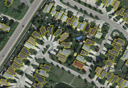
Automatically Extracted Buildings
“Automatically Extracted Buildings” is a raw digital product in vector format created by NRCan. The feature classes of this product delineate polygonal building footprints automatically extracted from airborne Lidar data, high-resolution optical imagery or other sources.
The first feature class, Automatically Extracted Buildings by acquisition source, contains building footprints delivered according to the spatial extent of each source dataset used for extraction. When the spatial extents of acquisition sources overlap, footprints for the same building may therefore be duplicated in this class.
The second feature class, Optimized Buildings Layer, is an assembled and harmonized layer derived from the buildings by acquisition source. Its objective is to provide a unique representation of each building footprint by removing duplicates and resolving overlaps between sources.
Simple
- Date ( RI_366 )
- 2018-11
- Date ( RI_367 )
- 2025-08
- Status
- onGoing; enContinue RI_596
- Maintenance and update frequency
- asNeeded; auBesoin RI_540
- Keywords ( RI_528 )
-
- Automatic Extraction
- LiDAR
- Government of Canada Core Subject Thesaurus Thésaurus des sujets de base du gouvernement du Canada ( RI_528 )
-
- Buildings
- Use limitation
- Open Government Licence - Canada (http://open.canada.ca/en/open-government-licence-canada)
- Access constraints
- license; licence RI_606
- Use constraints
- license; licence RI_606
- Spatial representation type
- vector; vecteur RI_635
- Metadata language
- eng; CAN
- Topic category
-
- Structure
- Begin date
- 2006
))
- Reference system identifier
- http://www.epsg-registry.org / EPSG:4617 /
- Distribution format
-
-
SHP
(
July 1998
)
- File decompression technique
- ZIP
-
GPKG
(
1.2.1
)
- File decompression technique
- ZIP
-
WMS
(
1.3.0
)
-
other
(
1.1.0
)
-
SHP
(
July 1998
)
- OnLine resource
-
Product Specifications
(
HTTPS
)
Supporting Document;PDF;eng
- OnLine resource
-
Prepackaged Geopackages (download directory)
(
HTTPS
)
Dataset;GPKG;eng
- OnLine resource
-
Optimized Buildings Layer (GeoParquet)
(
HTTPS
)
Dataset;other;zxx
- OnLine resource
-
Optimized Buildings Layer
(
HTTPS
)
Dataset;GPKG;zxx
- OnLine resource
-
GeoParquet: User Guide
(
HTTPS
)
Supporting Document;HTML;fra
- OnLine resource
-
GeoParquet: User guide
(
HTTPS
)
Supporting Document;HTML;eng
- OnLine resource
-
Product Specifications
(
HTTPS
)
Supporting Document;PDF;fra
- OnLine resource
-
Feature Catalogue
(
HTTPS
)
Supporting Document;HTML;eng
- OnLine resource
-
Feature Catalogue
(
HTTPS
)
Supporting Document;HTML;fra
- OnLine resource
-
Prepackaged Shapefiles (download directory)
(
HTTPS
)
Dataset;SHP;eng
- OnLine resource
-
Index of available files (drag and drop the kmz file in Google Earth to localize your region of interest)
(
HTTPS
)
Supporting Document;KMZ;zxx
- OnLine resource
-
Automatic Extraction of Building Footprints (Group layer)
(
OGC:WMS
)
Web Service;WMS;eng
- OnLine resource
-
Automatic Extraction of Building Footprints (Group layer)
(
OGC:WMS
)
Web Service;WMS;fra
- OnLine resource
-
Customized files (selectable extent, clipping and format) Geospatial-Data Extraction Tool (French interface)
(
HTTPS
)
Application;Web App;fra
- OnLine resource
-
Customized files (selectable extent, clipping and format) Geospatial-Data Extraction Tool (English interface)
(
HTTPS
)
Application;Web App;eng
- File identifier
- 7a5cda52-c7df-427f-9ced-26f19a8a64d6 XML
- Metadata language
- eng; CAN
- Character set
- utf8; utf8 RI_458
- Hierarchy level
- dataset; jeuDonnées RI_622
- Date stamp
- 2026-02-09T10:53:53
- Metadata standard name
- North American Profile of ISO 19115:2003 - Geographic information - Metadata
- Metadata standard version
- CAN/CGSB-171.100-2009
Overviews
Spatial extent
Provided by
