 Arctic SDI catalogue
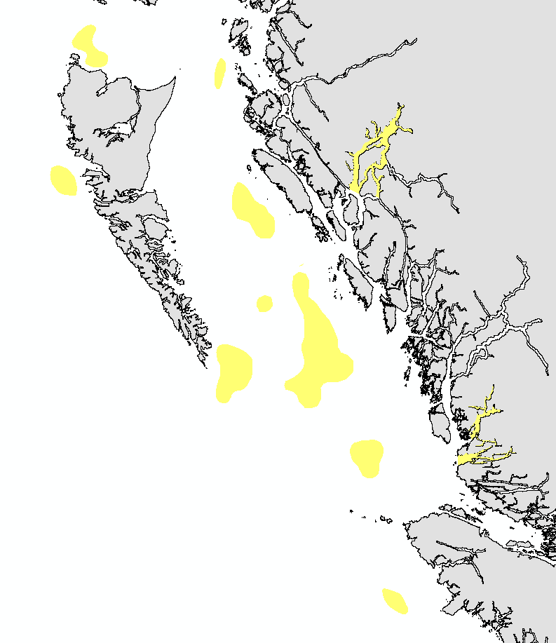
Important Areas for Coral and Sponge in Pacific North Coast Integrated Management Area
This layer details Important Areas (IAs) relevant to coral, sponge, and reef-building species in the Pacific North Coast Integrated Management Area (PNCIMA). This data was mapped to inform the selection of marine Ecologically and Biologically Significant Areas (EBSA). Experts have indicated that these areas are relevant based upon their high ranking in one or more of three criteria (Uniqueness, Aggregation, and Fitness Consequences). The distribution of IAs within ecoregions is used in the designation of EBSAs.
Canada’s Oceans Act provides the legislative framework for an integrated ecosystem approach to management in Canadian oceans, particularly in areas considered ecologically or biologically significant. DFO has developed general guidance for the identification of ecologically or biologically significant areas. The criteria for defining such areas include uniqueness, aggregation, fitness consequences, resilience, and naturalness. This science advisory process identifies proposed EBSAs in Canadian Pacific marine waters, specifically in the Strait of Georgia (SOG), along the west coast of Vancouver Island (WCVI, southern shelf ecoregion), and in the Pacific North Coast Integrated Management Area (PNCIMA, northern shelf ecoregion).
Initial assessment of IAs in PNCIMA was carried out in September 2004 to March 2005 with spatial data collection coordinated by Cathryn Clarke. Subsequent efforts in WCVI and SOG were conducted in 2009, and may have used different scientific advisors, temporal extents, data, and assessment methods. WCVI and SOG IA assessment in some cases revisits data collected for PNCIMA, but should be treated as a separate effort.
Other datasets in this series detail IAs for birds, cetaceans, fish, geographic features, invertebrates, and other vertebrates.
Though data collection is considered complete, the emergence of significant new data may merit revisiting of IAs on a case by case basis.
Simple
- Date ( RI_367 )
- 2019-03-31
- Date ( RI_366 )
- 2005-03-31
- Date ( RI_368 )
- 2025-07-23
- Status
- completed; complété RI_593
- Maintenance and update frequency
- notPlanned; nonPlanifié RI_542
- Keywords ( RI_528 )
-
- Environmental planning
- Marine ecosystems
- EBSA
- Important Areas
- Sponge reefs
- Reefs
- Keywords ( RI_525 )
-
- British Columbia
- Queen Charlotte Sound
- Queen Charlotte Basin
- PNCIMA
- Government of Canada Core Subject Thesaurus Thésaurus des sujets de base du gouvernement du Canada ( RI_528 )
-
- Environmental quality
- Ecology
- Classification
- unclassified; nonClassifié RI_484
- Use limitation
- Open Government Licence - Canada (http://open.canada.ca/en/open-government-licence-canada)
- Access constraints
- license; licence RI_606
- Use constraints
- license; licence RI_606
- Spatial representation type
- vector; vecteur RI_635
- Metadata language
- eng; CAN
- Character set
- utf8; utf8 RI_458
- Topic category
-
- Oceans
- Begin date
- 2004-09-01
- End date
- 2005-03-31
))
- Supplemental Information
-
Researchers with expertise for key sponge and coral taxa drew polygons on paper map to denote Important Areas for species that met a priori criteria. The experts' hand-drawn polygons were heads-up digitized using ArcView 3.2 on the 50,000 Canadian Hydrographic Service (CHS) coastline watershed basemap. Hand-drawn polygons were clipped using the PNCIMA boundary polygon provided by OHEB-GIS unit. The layers of individual experts were shared among all the experts for the species grouping. Experts were asked to provide confirmation and to check for accuracy and completeness. Any changes requested by the experts were performed and again returned to the experts for vetting.
The original HEB layer “NRCan Spongereefs” was compared to the most recent published reports of sponge reef locations in B.C. A field was added where arbitrary numbers were assigned to each of the sponge reef geographical groupings in order to remove the line work dividing the reefs into bioherms and biostromes to produce the sponge reefs layer.
Jeff Ardron performed density analysis on the coral and sponge bycatch data from the DFO observer database 1996-2002. Density analysis used 10 km kernel (decay). The twelve areas of concentration found during the analysis were presented in Ardron and Jamieson (2006). This data was provided to the Department of Fisheries and Oceans and was subsequently clipped to the PNCIMA boundary by Cathryn Clarke (Feb 4, 2005), and the IA project schema was applied to produce the bycatch layer.
The experts consulted were: Jeff Ardron (coral and sponge bycatch) and Jeff Marliave (sponge reefs, cloud sponge).
The dataset was updated in 2019 to conform to MSEA's GIS Hub publication standards. The PNCIMA IA data series was split into taxonomic themes (birds, cetaceans, coral and sponges, fish, geographic features, invertebrates, and other vertebrates). The Check Geometry tool was used to validate each layer.
This package also includes project documentation and tech reports relevant to the IA process and its role within the selection of EBSAs.
- Reference system identifier
- https://epsg.io / EPSG:4326 /
- Distribution format
-
-
FGDB/GDB
(
Unknown
)
-
GEOJSON
(
Unknown
)
-
FGDB/GDB
(
Unknown
)
- OnLine resource
-
Important Areas for Coral and Sponge in PNCIMA - Geodatabase
(
HTTPS
)
Dataset;FGDB/GDB;eng,fra
- OnLine resource
-
Data Dictionary
(
HTTPS
)
Supporting Document;HTML;eng,fra
- OnLine resource
-
References
(
HTTPS
)
Supporting Document;HTML;eng,fra
- OnLine resource
-
Important Areas for Coral and Sponge in PNCIMA - GeoJSON
(
HTTPS
)
Dataset;GEOJSON;eng,fra
- OnLine resource
-
IA for Coral and Sponge in PNCIMA - GIS Hub metadata
(
HTTPS
)
Supporting Document;PDF;eng
- OnLine resource
-
IA for Coral and Sponge in PNCIMA - GIS Hub metadata
(
HTTPS
)
Supporting Document;PDF;fra
- OnLine resource
-
Important Areas for Coral and Sponge in PNCIMA
(
ESRI REST: Map Server
)
Web Service;ESRI REST;eng
- OnLine resource
-
Important Areas for Coral and Sponge in PNCIMA
(
ESRI REST: Map Server
)
Web Service;ESRI REST;fra
- File identifier
- 7ad56d67-c4be-495b-82ef-3bff57c986a4 XML
- Metadata language
- eng; CAN
- Character set
- utf8; utf8 RI_458
- Hierarchy level
- dataset; jeuDonnées RI_622
- Date stamp
- 2025-07-23T21:49:23.926Z
- Metadata standard name
- North American Profile of ISO 19115:2003 - Geographic information - Metadata
- Metadata standard version
- CAN/CGSB-171.100-2009
Overviews
Spatial extent
Provided by
