 Arctic SDI catalogue
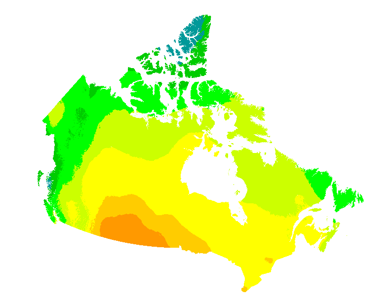
Photovoltaic Potential and Solar Resource Maps of Canada
This web mapping application gives estimates of the electricity that can be generated by grid-connected photovoltaic systems without batteries (in kWh/kWp) and of the mean daily global insolation (in MJ/m2 and in kWh/m2) for any location in Canada on a 60 arc seconds ~2 km grid. They are presented for each month and for the entire year, for six different PV array orientations: a sun-tracking orientation and five fixed South-facing orientations with latitude, vertical (90°), horizontal (0°) and latitude ± 15° tilts. Data can also be obtained directly for individual municipalities from a list of over 3500 municipalities or downloaded for all municipalities at once.
These maps and datasets were developed by the Canadian Forest Service (Great Lakes Forestry Centre) in collaboration with the CanmetENERGY Photovoltaic systems group and the Federal Geospatial Platform. Insolation data were provided by Environment and Climate Change Canada. Web map application developed by Federal Geospatial Platform, 2020.
References:
Pelland S., McKenney D. W., Poissant Y., Morris R., Lawrence K., Campbell K. and Papadopol P., 2006. The Development of Photovoltaic Resource Maps for Canada, In Proceedings of the Annual Conference of the Solar Energy Society of Canada (SESCI) 2006.
McKenney D. W., Pelland S., Poissant Y., Morris R., Hutchinson M, Papadopol P., Lawrence K. and Campbell K., 2008. Spatial insolation models for photovoltaic energy in Canada, Solar Energy 82, pp. 1049–1061.
Simple
- Date ( RI_367 )
- 2020
- Date ( RI_366 )
- 2020
- Status
- completed; complété RI_593
- Maintenance and update frequency
- asNeeded; auBesoin RI_540
- Keywords ( RI_528 )
-
- Photovoltaic
- Radiation
- Solar
- Government of Canada Core Subject Thesaurus Thésaurus des sujets de base du gouvernement du Canada ( RI_528 )
-
- Climate
- Solar energy
- Use limitation
- Open Government Licence - Canada (http://open.canada.ca/en/open-government-licence-canada)
- Access constraints
- license; licence RI_606
- Use constraints
- license; licence RI_606
- Use constraints
- otherRestrictions; autresRestrictions RI_609
- Other constraints
- Any reproduction or public use of these maps or datasets should mention “© Her Majesty the Queen in Right of Canada, as represented by the Minister of Natural Resources, 2020”.
- Spatial representation type
- grid; grille RI_636
- Metadata language
- eng
- Metadata language
- fra
- Topic category
-
- Climatology, meteorology, atmosphere
- Begin date
- 1974
- End date
- 1993
))
- Reference system identifier
- http://www.epsg-registry.org / EPSG:3978 /
- Distribution format
-
-
ESRI REST
(
10.8.1
)
-
FGDB/GDB
(
10
)
-
CSV
(
N/A
)
-
ESRI REST
(
10.8.1
)
- OnLine resource
-
Cartography data (with ArcMap project file) - Photovoltaic potential and solar resource maps of Canada, File Geodatabase
(
HTTPS
)
Dataset;FGDB/GDB;eng,fra
- OnLine resource
-
Municipality database - Mean daily global insolation (MJ/m²)
(
HTTPS
)
Dataset;CSV;eng,fra
- OnLine resource
-
Municipality database - Mean daily global insolation (kWh/m²)
(
HTTPS
)
Dataset;CSV;eng,fra
- OnLine resource
-
Municipality database - Photovoltaic potential (kWh/kWp)
(
HTTPS
)
Dataset;CSV;eng,fra
- OnLine resource
-
Application data - Photovoltaic potential and solar resource maps of Canada
(
HTTPS
)
Web Service;ESRI REST;eng
- OnLine resource
-
Application data - Photovoltaic potential and solar resource maps of Canada
(
HTTPS
)
Web Service;ESRI REST;fra
- OnLine resource
-
Application - Photovoltaic potential and solar resource maps of Canada
(
HTTPS
)
Application;Web App;eng
- OnLine resource
-
Application - Photovoltaic potential and solar resource maps of Canada
(
HTTPS
)
Application;Web App;fra
- File identifier
- 8b434ac7-aedb-4698-90df-ba77424a551f XML
- Metadata language
- eng; CAN
- Character set
- utf8; utf8 RI_458
- Hierarchy level
- dataset; jeuDonnées RI_622
- Date stamp
- 2023-11-30T10:46:36
- Metadata standard name
- North American Profile of ISO 19115:2003 - Geographic information - Metadata
- Metadata standard version
- CAN/CGSB-171.100-2009
Overviews

Spatial extent
Provided by
