 Arctic SDI catalogue
Monitoring regional conservation areas using paired environmental DNA and research trawl surveys
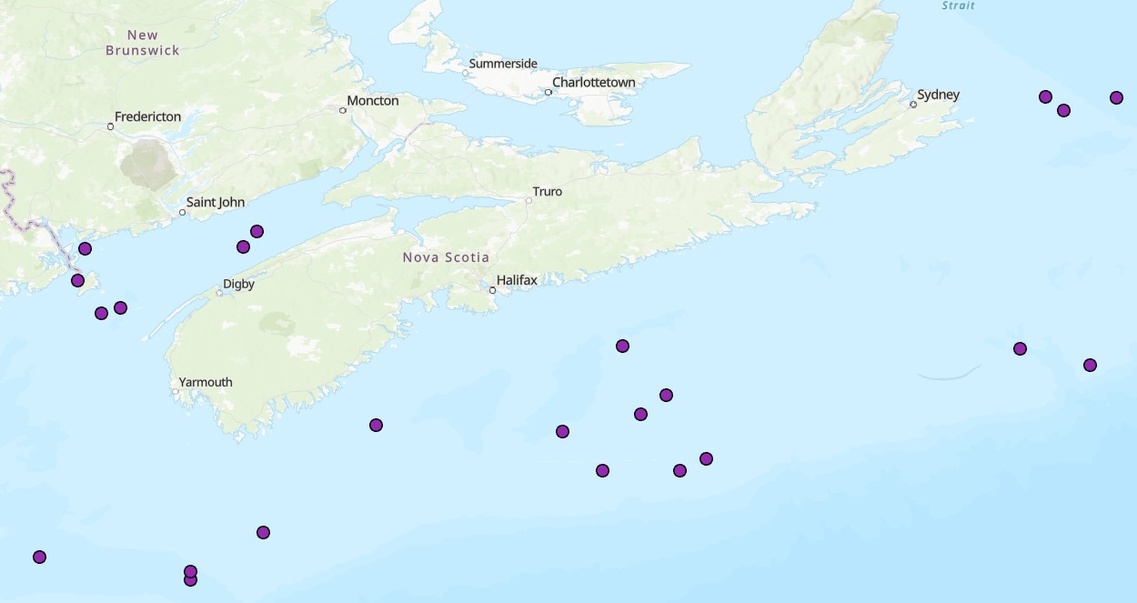
DFO has committed to establishing a representative network of Marine Conservation Areas collectively comprising 30% of the EEZ by 2030. The MCT 2.0 program was established in 2021 to help achieve this target and establish long-term monitoring within Canadian conservation areas. Information on the distribution of species within a protected area is essential for the management and monitoring of a site. Decisions made on zoning, risk assessment, activity approvals and management effectiveness all require information on the distribution and status of species. The Scotian Shelf-Bay of Fundy Bioregion spans the domain of the Maritimes Region, and within it there are 8 Marine Refuges (MR), 3 Marine Protected Areas (MPA), and 2 Areas of Interest (AOI). Environmental DNA (eDNA) offers a promising approach for biodiversity monitoring that has been gaining increased attention in the marine realm. Through sampling relatively small volumes of water (~3L), eDNA can capture of millions of fragments of eDNA on specialized filters that can then be sequenced to identify the species composition of an area. eDNA metabarcoding is based on the foundations of DNA barcoding, where species are identified solely by their unique DNA sequences. This method is relatively simple, efficient (with the ability to characterize both fish and invertebrate diversity), and non-invasive, meaning there is no disruption of sensitive benthic habitats or need to dissect tissue samples from captured fish and invertebrates. eDNA has been shown to be comparable to other biodiversity censusing techniques and has the potential to rapidly conduct biodiversity surveys over a relatively large area, such as the Eastern Shore Islands AOI. The DFO Maritimes summer multispecies trawl survey is one of the longest-running data series with applications in fisheries stock assessment, and one of the only sources of data for offshore MPA design and monitoring. In this project we pair eDNA samples collected within current and proposed conservation areas with trawl catch data to create a biodiversity and animal community monitoring time series for these areas. We use eDNA and trawl catch data as complementary tools, where trawl-based catch provides information on fish abundance, size distributions and sex, and eDNA provides information on genetic diversity and can detect cryptic and rare species.
Cite this data as: Jeffery, N.W. Monitoring regional conservation areas using paired environmental DNA and research trawl surveys. Published: May 2026. Coastal Ecosystems Science Division, Maritimes Region, Fisheries and Oceans Canada, Dartmouth NS.
Simple
- Date ( RI_367 )
- 2026-05-19
- Date ( RI_366 )
- 2026-04-15
- Status
- onGoing; enContinue RI_596
- Maintenance and update frequency
- asNeeded; auBesoin RI_540
- Keywords
-
- Marine Conservation Target
- Trawl survey
- eDNA
- Marine refuges
- Government of Canada Core Subject Thesaurus Thésaurus des sujets de base du gouvernement du Canada ( RI_528 )
-
- Marine conservation areas
- Genetics
- Use limitation
- Open Government Licence - Canada (http://open.canada.ca/en/open-government-licence-canada)
- Access constraints
- license; licence RI_606
- Use constraints
- license; licence RI_606
- Classification
- unclassified; nonClassifié RI_484
- Spatial representation type
- vector; vecteur RI_635
- Metadata language
- eng; CAN
- Character set
- utf8; utf8 RI_458
- Topic category
-
- Oceans
- Biota
- Environment
- Begin date
- 2023-07-01
- End date
- 2025-08-20
))
- Reference system identifier
- https://epsg.io / EPSG:4326 / 8.2.6
- Distribution format
-
-
ESRI REST
(
2.9.8
)
-
CSV
(
1
)
-
FGDB/GDB
(
2.9.8
)
-
ZIP
(
N/A
)
-
ESRI REST
(
2.9.8
)
- OnLine resource
-
COI-1 Sequence
(
HTTPS
)
Dataset;ZIP;zxx
- OnLine resource
-
12S Sequence
(
HTTPS
)
Dataset;ZIP;zxx
- OnLine resource
-
2025 Offshore eDNA sample metadata
(
HTTPS
)
Dataset;ZIP;eng,fra
- OnLine resource
-
Summer 2025 Maritimes sample stations
(
HTTPS
)
Dataset;FGDB/GDB;eng,fra
- OnLine resource
-
Monitoring regional conservation areas using paired environmental DNA and research trawl surveys
(
ESRI REST: Map Service
)
Web Service;ESRI REST;eng
- OnLine resource
-
Monitoring regional conservation areas using paired environmental DNA and research trawl surveys
(
ESRI REST: Map Service
)
Web Service;ESRI REST;fra
- OnLine resource
-
Data dicationary
(
HTTPS
)
Supporting Document;CSV;eng,fra
- File identifier
- 91baebd7-0832-455c-a4bf-67a1d0d6672d XML
- Metadata language
- eng; CAN
- Character set
- utf8; utf8 RI_458
- Hierarchy level
- dataset; jeuDonnées RI_622
- Date stamp
- 2026-05-13T10:29:00.542409Z
- Metadata standard name
- North American Profile of ISO 19115:2003 - Geographic information - Metadata
- Metadata standard version
- CAN/CGSB-171.100-2009
Overviews
Spatial extent
Provided by
