 Arctic SDI catalogue
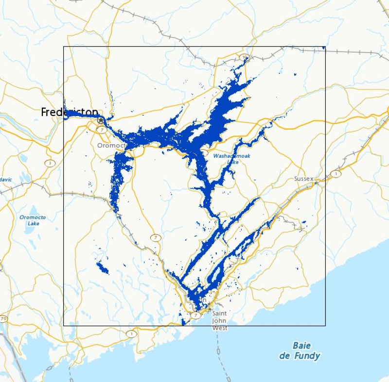
Active Floods in Canada
Flood extent polygons from the last three days in selected Canadian regions that have been designated for observation, monitored by Natural Resources Canada using satellite imagery for emergency response. Coverage is not comprehensive nationwide.
In response to large flood events, Natural Resources Canada (NRCan), for the provision of emergency geomatics services, may be activated by Canada’s emergency management protocols. As new satellite imagery becomes available, NRCan will extract flood extent polygons and update the dataset in near real time (4 hours). This item contains the latest flood products generated in the past three days. For any data older than 72 hours, please refer to the [Floods in Canada - Current Year](https://open.canada.ca/data/en/dataset/b1afd8d2-6e14-4ec4-9a09-652221a6cb71) entry. Note that the web mapping service may not display data if flood polygons have not been published by the EGS in the past three days.
The flood products generated are validated on a best effort basis. Various factors may affect the quality of the flood polygons. These factors include, but are not limited to, sensor type, image resolution, cloud cover or limitations of the flood polygon extraction method. In this layer, where possible, a symbology is applied to the flood polygons based on the underlying land use classification, or is simply unclassified and shows the raw flood extent. When using Web mapping services, to display a specific product, filter by date (UTC Date) and area of interest (AOI). Also, a link to download each product directly is available in the Resources section. This prepackaged and compressed product contains a Shape file, a PDF file and a KMZ file.
Disclaimer:
Emergency response authorities are the primary users of these satellite-derived open water flood extent map products. These products are generated to provide analysis and emergency response situational awareness and to facilitate decision-making during major flood events. The open water flood extent products are generated rapidly and limited time is available for editing and validation. The flood products reflect the open water flood conditions at the date/time of acquisition. While efforts are made to produce high quality products, near-real time products may contain errors due to the limited time available for vector editing and validation. Please note that current algorithms do not map flooded areas under the forest canopy and are not optimized for urban flood mapping.
Limitation of Liability:
Accordingly, the information contained on this website is provided on an “as is” basis and Natural Resources Canada makes no representations or warranties respecting the information, either expressed or implied, arising by law or otherwise, including but not limited to, effectiveness, completeness, accuracy or fitness for a particular purpose. Natural Resources Canada does not assume any liability in respect of any damage or loss based on the use of this website. In no event shall Natural Resources Canada be liable in any way for any direct, indirect, special, incidental, consequential, or other damages based on any use of this website or any other website to which this site is linked, including, without limitation, any lost profits or revenue or business interruption.
Parent Collection:
- **[Floods in Canada - Cartographic Product Collection](https://open.canada.ca/data/en/dataset/08b810c2-7c81-40f1-adb1-c32c8a2c9f50)**
Simple
- Date ( RI_367 )
- 2018-04-12
- Date ( RI_366 )
- 2011-04-29
- Status
- onGoing; enContinue RI_596
- Maintenance and update frequency
- irregular; irrégulier RI_541
- Keywords ( RI_528 )
-
- Footprint
- Government of Canada Core Subject Thesaurus Thésaurus des sujets de base du gouvernement du Canada ( RI_528 )
-
- Emergency services
- Floods
- Natural disasters
- Use limitation
- Open Government Licence - Canada (http://open.canada.ca/en/open-government-licence-canada)
- Access constraints
- license; licence RI_606
- Use constraints
- license; licence RI_606
- Spatial representation type
- vector; vecteur RI_635
- Metadata language
- eng; CAN
- Metadata language
- fra
- Character set
- utf8; utf8 RI_458
- Topic category
-
- Inland waters
- Begin date
- 2026-01-01
- End date
- 2026-12-31
))
- Reference system identifier
- http://www.epsg-registry.org / EPSG:4326 /
- Reference system identifier
- http://www.epsg-registry.org / EPSG:3857 /
- Distribution format
-
-
FGDB/GDB
(
10.3.1
)
- File decompression technique
- ZIP
-
SHP
(
Unknown
)
- File decompression technique
- ZIP
-
KMZ
(
2.2
)
-
ESRI REST
(
10.7.1
)
-
WMS
(
1.3.0
)
- Specification
- Open Geospatial Consortium Inc., OpenGIS Web Map Service (WMS) Implementation Specification, Version 1.3.0, 2006-03-15, Reference number of this OGC® project document: 06-042
-
FGDB/GDB
(
10.3.1
)
- OnLine resource
-
Active Floods in Canada
(
ESRI REST: Map Server
)
Web Service;ESRI REST;eng
- OnLine resource
-
Prepackaged files sorted by year (download directory)
(
HTTPS
)
Dataset;SHP;eng,fra
- OnLine resource
-
Prepackaged files sorted by year (download directory)
(
HTTPS
)
Dataset;SHP;eng,fra
- OnLine resource
-
Active Floods in Canada
(
ESRI REST: Map Server
)
Web Service;ESRI REST;fra
- OnLine resource
-
Active Floods in Canada
(
OGC:WMS
)
Web Service;WMS;eng
- OnLine resource
-
Active Floods in Canada
(
OGC:WMS
)
Web Service;WMS;fra
- OnLine resource
-
Floods in Canada - Active
(
HTTPS
)
Dataset;FGDB/GDB;eng
- OnLine resource
-
Open Water Flood Guide
(
HTTPS
)
Supporting Document;PDF;eng
- OnLine resource
-
Open Water Flood Guide
(
HTTPS
)
Supporting Document;PDF;fra
- File identifier
- 9cad712a-5ac5-4248-b7d7-2db1a3892509 XML
- Metadata language
- eng; CAN
- Character set
- utf8; utf8 RI_458
- Parent identifier
- Floods in Canada - Cartographic Product Collection 08b810c2-7c81-40f1-adb1-c32c8a2c9f50
- Hierarchy level
- dataset; jeuDonnées RI_622
- Date stamp
- 2026-03-30T09:50:23
- Metadata standard name
- North American Profile of ISO 19115:2003 - Geographic information - Metadata
- Metadata standard version
- CAN/CGSB-171.100-2009
Overviews

Spatial extent
Provided by
