 Arctic SDI catalogue
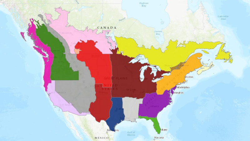
Canada US Crop Field Trial Regions
There are fourteen major and four minor field trial regions in Canada and USA. Each of these regions recognizes physical characteristics, such as soils, and crops and climate, that make the region unique. The subzones address differences within a region, generally reflected in the types of crops grown in that region. The Canadian regions, as much as possible, correspond to the U.S. regions.
The trial regions contain number of field trials by specific crop.
Simple
- Date ( RI_366 )
- 2019-07-03
- Date ( RI_367 )
- 1998-06-01
- Presentation form
- mapDigital;carteNumérique RI_391
- Status
- completed; complété RI_593
- Maintenance and update frequency
- asNeeded; auBesoin RI_540
- Keywords ( RI_528 )
-
- Boundaries
- pest management
- crop
- Government of Canada Core Subject Thesaurus Thésaurus des sujets de base du gouvernement du Canada ( RI_528 )
-
- Pesticides
- Boundaries
- Use limitation
- Open Government Licence - Canada (http://open.canada.ca/en/open-government-licence-canada)
- Use limitation
- Open Government Licence - Canada (http://open.canada.ca/en/open-government-licence-canada)
- Access constraints
- license; licence RI_606
- Use constraints
- license; licence RI_606
- Spatial representation type
- vector; vecteur RI_635
- Metadata language
- boundaries
- Topic category
-
- Boundaries
- Begin date
- 2019-06-01
))
- Reference system identifier
- http://www.epsg-registry.org/ / EPSG:3857 / 8.1.4
- OnLine resource
-
Data Product Specification (English)
(
HTTPS
)
Supporting Document;PDF;eng
- OnLine resource
-
Data Product Specification (French)
(
HTTPS
)
Supporting Document;PDF;fra
- OnLine resource
-
Pre-packaged FGDB files
(
HTTPS
)
Dataset;FGDB/GDB;eng,fra
- OnLine resource
-
Pre-packaged GeoJSON files
(
HTTPS
)
Dataset;GEOJSON;eng,fra
- OnLine resource
-
Canada US Crop Field Trial Regions (AGOL)
(
HTTPS
)
Web Service;ESRI REST;eng,fra
- OnLine resource
-
Crop Field Trial Regions and Safe Zones (English)
(
HTTPS
)
Application;Web App;eng
- OnLine resource
-
Crop Field Trial Regions and Safe Zones (French)
(
HTTPS
)
Application;Web App;fra
- File identifier
- bee2dd44-963c-4854-b72f-0a70b55964ab XML
- Metadata language
- eng; CAN
- Character set
- utf8; utf8 RI_458
- Parent identifier
- Crop Field Trial Regions aec30fed-3572-4672-bcd7-7b3efdbe7fae
- Hierarchy level
- dataset; jeuDonnées RI_622
- Date stamp
- 2025-12-18T13:56:08
- Metadata standard name
- North American Profile of ISO 19115:2003 - Geographic information - Metadata
- Metadata standard version
- CAN/CGSB-171.100-2009
Overviews

Spatial extent
Provided by
