 Arctic SDI catalogue
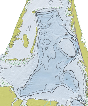
Bathymetry of the Magdalen Islands Lagoons Marine Refuge
This bathymetric dataset of the five inland water bodies of the Magdalen Islands was produced by the Quebec Regional Science Directorate (DRS) of Fisheries and Oceans Canada (DFO) as part of the characterization of the Magdalen Islands lagoon marine refuge.
The data comes from several sources, including a bathymetric LiDAR survey, satellite-derived bathymetry (SDB), acoustic surveys, and spot depth sampling conducted in inland water bodies.
The final product is a 5 m resolution raster projected in NAD83 / MTM zone 4. Depths are expressed in meters and reduced to chart datum (CD). This dataset is provided for information, analysis, and research purposes and is not intended for navigation.
This dataset is a derived scientific product generated through processing, interpolation, and integration conducted by a DRS research team, and it does not constitute a hydrographic product of the Canadian Hydrographic Service (CHS). The data may contain uncertainties, acquisition artifacts, or processing errors, and do not meet the hydrographic standards of the International Hydrographic Organization (IHO).
This dataset is provided exclusively for informational, analytical, management, and scientific research purposes. It must not be used for navigation, for operational decision‑making at sea, or for any activity where the safety of persons or property may depend on the accuracy of depth information.
DFO and CHS disclaim all liability for the use, interpretation, or decisions made on the basis of this product.
For more information on the methodology and an overview of the results, see the report by Grégoire et al. (2026).
Simple
- Date ( RI_367 )
- 2026-03
- Date ( RI_366 )
- 2026-02
- Status
- completed; complété RI_593
- Maintenance and update frequency
- notPlanned; nonPlanifié RI_542
- Keywords
-
- Bathymetry
- Magdalen Islands
- Marine refuge
- Marine conservation
- Lagoon
- Government of Canada Core Subject Thesaurus Thésaurus des sujets de base du gouvernement du Canada ( RI_528 )
-
- Oceans
- Inland waters
- Use limitation
- Open Government Licence - Canada (http://open.canada.ca/en/open-government-licence-canada)
- Access constraints
- license; licence RI_606
- Use constraints
- license; licence RI_606
- Classification
- unclassified; nonClassifié RI_484
- Spatial representation type
- grid; grille RI_636
- Metadata language
- fra; CAN
- Topic category
-
- Elevation
- Oceans
- Inland waters
- Begin date
- 2023-05
- End date
- 2024-11
- Description
- Magdalen Islands
))
- Reference system identifier
- NAD83 / MTM zone 4 / EPSG:32184 /
- Distribution format
-
-
GeoTIF
(
1
)
-
GeoTIF
(
1
)
- OnLine resource
-
Data dictionary for Magdalen Islands bathymetry data
(
HTTPS
)
Supporting Document;CSV;eng,fra
- OnLine resource
-
Raster for Magdalen Islands bathymetry
(
HTTPS
)
Dataset;GeoTIF;eng,fra
- OnLine resource
-
References
(
HTTPS
)
Supporting Document;PDF;eng,fra
- OnLine resource
-
Map service for bathymetry data (MI)
(
ESRI REST: Map Service
)
Web Service;ESRI REST;eng
- OnLine resource
-
Map service for bathymetry data (MI)
(
ESRI REST: Map Service
)
Web Service;ESRI REST;fra
- File identifier
- c8b0a332-1996-4cf2-a06d-5e82feb26478 XML
- Metadata language
- eng; CAN
- Character set
- utf8; utf8 RI_458
- Hierarchy level
- dataset; jeuDonnées RI_622
- Date stamp
- 2026-05-01T15:29:03.821977Z
- Metadata standard name
- North American Profile of ISO 19115:2003 - Geographic information - Metadata
- Metadata standard version
- CAN/CGSB-171.100-2009
Overviews
Spatial extent
Provided by
