 Arctic SDI catalogue
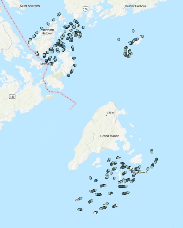
Benthic Species Presence/Absence in the Lower Bay of Fundy Derived From High Resolution Video and Still Imagery
Funded through DFO's Strategic Program for Ecosystem-based Research and Advice (SPERA), this benthic survey covers several seabed areas adjacent to Deer Island and Campobello Island, the Wolves Islands, and Grand Manan (NB) over a two-year study period (2016-2017). One hundred and fifty drift camera transects were completed within the ~91 sq-km study region collecting continuous high-definition video with periodic 4K resolution video (provided by a downward facing Blackmagic Production Camera 4K equipped with video lights). A Nikon D800 36.1 megapixel digital still imagery camera (equipped with a studio strobe light) captured seafloor images at ~30s intervals over a maximum 25-minute drift survey period. The camera was triggered by lowering the camera frame within 1 m of the seabed, releasing tension on a trigger weight suspended below the frame. Camera location was tracked using an ultra-short baseline acoustic positioning system (Tracklink 1500HA transceiver with 1505B transponder on the camera frame). Species presence/absence, abundance, and bottom type was recorded manually using PhotoQuad v1.4 software. An average field of view of 0.7 x 0.5 m was determined from a subset of digital still images within which the 10 cm diameter trigger weight was fully in view. Thirty-two key and common taxa were described using explicit taxonomic identifiers, while other species were recorded within broader general categories (e.g. unidentified Cnidaria). Identification was made to the lowest possible taxonomic level. Primary bottom-type was defined as the grain size with the most percent coverage for each image/video interval. Grain size limits were determined using the Wentworth scale. For complete and standardized dataset including continuous video benthic taxa occurrences, see https://obis.org/dataset/6e214947-9972-4b5b-9b1e-23d8eded90ba
Cite this data as: Lawton P. Benthic Species Presence/Absence in the Lower Bay of Fundy Derived From High Resolution Video and Still Imagery. Published May 2022. Coastal Ecosystems Science Division, Fisheries and Oceans Canada, Dartmouth, N.S.
Simple
- Date ( RI_366 )
- 2022-05-30
- Date ( RI_367 )
- 2022-05-30
- Status
- completed; complété RI_593
- Maintenance and update frequency
- notPlanned; nonPlanifié RI_542
- Government of Canada Core Subject Thesaurus Thésaurus des sujets de base du gouvernement du Canada ( RI_528 )
-
- Environment
- Oceans
- Classification
- unclassified; nonClassifié RI_484
- Use limitation
- Open Government Licence - Canada (http://open.canada.ca/en/open-government-licence-canada)
- Access constraints
- license; licence RI_606
- Use constraints
- license; licence RI_606
- Spatial representation type
- vector; vecteur RI_635
- Metadata language
- eng; CAN
- Character set
- utf8; utf8 RI_458
- Topic category
-
- Environment
- Oceans
- Biota
- Begin date
- 2016-07-12
- End date
- 2017-09-15
))
- Reference system identifier
- https://epsg.io / EPSG:4326 /
- Distribution format
-
-
CSV
(
1
)
-
ESRI REST
(
2.7.0
)
-
FGDB/GDB
(
2.7.0
)
-
CSV
(
1
)
- OnLine resource
-
Benthic Species Presence/Absence in the Lower Bay of Fundy Derived From High Resolution Video and Still Imagery
(
ESRI REST: Map Service
)
Web Service;ESRI REST;eng
- OnLine resource
-
Benthic Species Presence/Absence in the Lower Bay of Fundy Derived From High Resolution Video and Still Imagery
(
ESRI REST: Map Service
)
Web Service;ESRI REST;fra
- OnLine resource
-
Presence/absence and abundance of vulnerable marine ecosystem species Boltenia ovifera and Modiolus modiolus in the lower Bay of Fundy derived from high resolution still imagery
(
HTTPS
)
Supporting Document;HTML;eng,fra
- OnLine resource
-
Data dictionary
(
HTTPS
)
Supporting Document;CSV;eng,fra
- OnLine resource
-
Benthic Species Presence/Absence in the Lower Bay of Fundy Derived From High Resolution Video and Still Imagery
(
HTTPS
)
Dataset;FGDB/GDB;eng,fra
- OnLine resource
-
Benthic Species Presence/Absence in the Lower Bay of Fundy Derived From High Resolution Video and Still Imagery
(
HTTPS
)
Dataset;CSV;eng,fra
- File identifier
- e736c0f0-b19e-4842-903d-28bfc756d48a XML
- Metadata language
- eng; CAN
- Character set
- utf8; utf8 RI_458
- Hierarchy level
- series; série RI_623
- Date stamp
- 2026-05-15T11:33:44.819799Z
- Metadata standard name
- North American Profile of ISO 19115:2003 - Geographic information - Metadata
- Metadata standard version
- CAN/CGSB-171.100-2009
Overviews
Spatial extent
Provided by
