 Arctic SDI catalogue
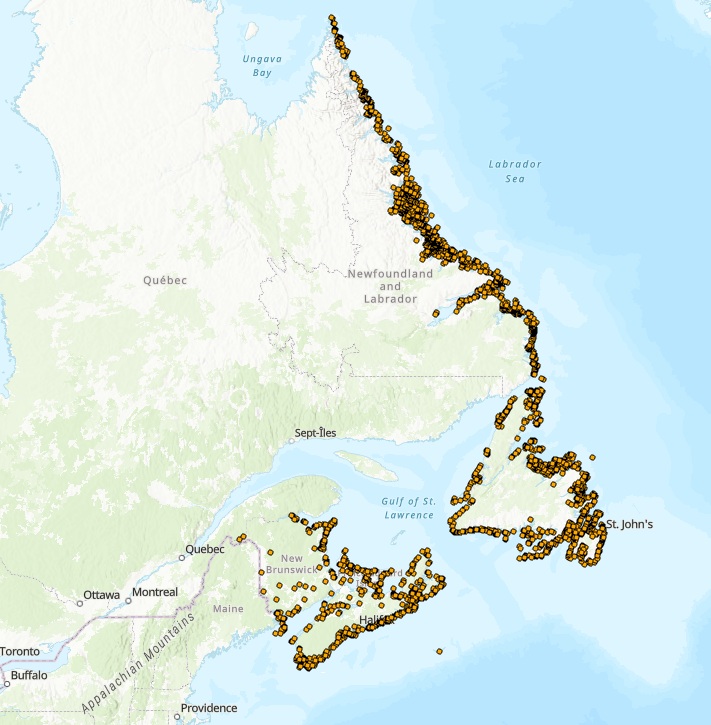
CWS Atlantic Colonial Waterbird Monitoring
The Atlantic Colonial Waterbird Monitoring database captures geo-referenced data collected under the Atlantic Region’s Canadian Wildlife Service (CWS) Colonial Seabird Monitoring program, and data collected under CWS’ waterfowl and protected areas programs. These programs collectively monitor 22 species of colonial waterbirds breeding in the Atlantic Region of the following groups: fulmars, shearwaters, storm-petrels, gannets, gulls, terns, alcids, eiders, herons and cormorants, with the primary outcome to update information on the distribution, status, and trends of waterbirds breeding in all four Atlantic provinces.
Surveys are conducted using one of three platforms: aerial, boat, or ground. Aerial surveys provide the most cost-effective way of conducting a comprehensive population census of diurnal species visible from air, namely gulls (Herring, Great Black-backed, Ring-billed, Glaucous), Black-legged Kittiwakes, Northern Gannets, terns (Arctic, Common, Roseate, Caspian), cormorants (Greater, Double-crested), Black Guillemots, and Common Eiders.
Aerial surveys are also effective in identifying new colonies and provide additional information on how to most effectively conduct boat and ground surveys. Boat and ground surveys are conducted at smaller geographic scales and are necessary to obtain complementary information on the species composition of colonies and correction factors to finalize gull, tern and eider estimates obtained from the aerial surveys. Ground and/or boat surveys are also necessary to conduct colony counts of cliff-nesting birds (murres and fulmars), crevice nesting birds (razorbills and guillemots) and burrow-nesting birds (puffins, storm-petrels, shearwaters).
Raw data are captured using various survey methods, including:1) visual estimates, 2) direct counts of number of individuals or apparently occupied sites and/or photo counts, 3) sub-sampling the colony through plot counts and extrapolating the estimated occupied densities over the occupied area which in turn is estimated using a variety of geographic information system approaches (e.g., Wilhelm et al. 2015).
Important outcomes for how data are used include informing marine spatial planning, emergency preparedness, impact assessment of various anthropogenic threats, and COSEWIC status assessment (e.g., COSEWIC 2020). Further, these data are regularly used internally or in collaboration with partners to form the basis of peer-reviewed publications on regional, national, and/or global population trends for target species (e.g., Langlois Lopez et al. 2022, Iles et al. 2025).
This dataset represents a subset of data collected from surveys led by CWS spanning from 1910 to 2024 and summarized to present, at a given colony, the year and count of birds from the most recent survey, the year and maximum count of birds within the last 20 years (if available), and the year and maximum count of birds ever recorded. In addition, CWS works closely with a variety of partners (e.g., provincial, other federal departments, academic, not-for profit organizations) to supplement colonial waterbird data collected in the Atlantic Region. To request additional census or survey data, please contact CWS.
COSEWIC. 2020. COSEWIC assessment and status report on the Leach’s Storm-Petrel (Atlantic population) Oceanodroma leucorhoa in Canada. Committee on the Status of Endangered Wildlife in Canada. Ottawa. xii + 70 pp. (https://www.canada.ca/en/environment-climate-change/services/species-risk-public-registry.html).
Iles, D.T., S.E. Gutowsky, A.M. Calvert, S.I. Wilhelm, J.-F. Rail, A. Hedd, H.L. Major, A.C. Smith, and G.J. Robertson. 2025. Estimating regional trajectories and trends of seabirds from sparse and inconsistent colony counts: case studies from eastern Canada with Leach’s Storm-Petrel and Atlantic Puffin. Avian Conservation and Ecology 20(2):16. https://doi.org/10.5751/ACE-02931-200216
Langlois Lopez, S., Bond, A.L., O’Hanlon, N.J., Wilson, J.M., Vitz, A., Mostello, C.S., Hamilton, F., Rail, J.-F., Welch, L., Boettcher, R., Wilhelm, S.I., Anker-Nilssen, T., Daunt, F., and Masden, E. 2022. Global population and conservation status of the Great Black-backed Gull Larus marinus. Bird Conservation International, 1–11. https://doi.org/10.1017/S0959270922000181
Wilhelm, S.I., Mailhiot, J., Arany, J., Chardine, J.W., Robertson, G.J., and Ryan, P.C. 2015. Update and trends of three important seabird populations in the western North Atlantic using a geographic information system approach. Marine Ornithology 43: 211-222.
Simple
- Date ( RI_367 )
- 2026-01-30
- Date ( RI_366 )
- 2026-01-08
- Status
- onGoing; enContinue RI_596
- Maintenance and update frequency
- annually; annuel RI_539
- Government of Canada Core Subject Thesaurus Thésaurus des sujets de base du gouvernement du Canada ( RI_528 )
-
- Migratory birds
- Program (PAA) Portée du programme (PAA) ( RI_528 )
-
- 1.1.3. Migratory Birds
- ECCC Geographic Scope EN ECCC Geographic Scope FR ( Place )
-
- Atlantic
- Use limitation
- Open Government Licence - Canada (http://open.canada.ca/en/open-government-licence-canada)
- Access constraints
- license; licence RI_606
- Use constraints
- license; licence RI_606
- Spatial representation type
- vector; vecteur RI_635
- Metadata language
- eng; CAN
- Character set
- UTF8
- Topic category
-
- Biota
- Begin date
- 1910-01-01
- End date
- 2024-12-31
))
- Reference system identifier
- https://epsg.io / EPSG:4326 /
- Distribution format
-
-
CSV
(
1
)
-
FGDB/GDB
(
1
)
-
CSV
(
1
)
- OnLine resource
-
View ECCC Data Mart (English)
(
HTTPS
)
Web Service;HTML;eng
- OnLine resource
-
View ECCC Data Mart (French)
(
HTTPS
)
Web Service;HTML;fra
- OnLine resource
-
Atlantic Colonial Waterbirds
(
ESRI REST: Map Service
)
Web Service;ESRI REST;eng
- OnLine resource
-
Atlantic Colonial Waterbirds
(
ESRI REST: Map Service
)
Web Service;ESRI REST;fra
- OnLine resource
-
Atlantic Colonial Waterbirds
(
OGC:WMS
)
Web Service;WMS;eng
- OnLine resource
-
Atlantic Colonial Waterbirds
(
OGC:WMS
)
Web Service;WMS;fra
- File identifier
- efe2be8d-f039-4c52-8e88-974166b082c9 XML
- Metadata language
- eng; CAN
- Character set
- utf8; utf8 RI_458
- Hierarchy level
- dataset; jeuDonnées RI_622
- Date stamp
- 2026-04-07T13:25:26.268354Z
- Metadata standard name
- North American Profile of ISO 19115:2003 - Geographic information - Metadata
- Metadata standard version
- CAN/CGSB-171.100-2009
Overviews
Spatial extent
Provided by
