 Arctic SDI catalogue
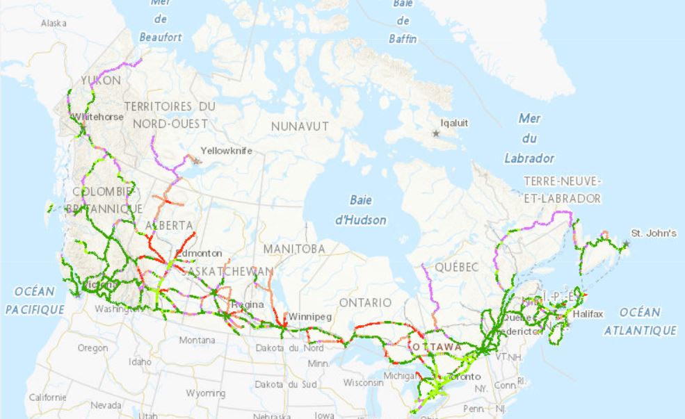
Planning Map for Public EV Charging Infrastructure
The Zero Emission Vehicle Infrastructure Program (ZEVIP) aims at addressing the lack of charging infrastructure in Canada, one of the key barriers to zero emission vehicle adoption by increasing the availability of localized charging where Canadians live, work, travel and play. This Planning Map for Public EV Charging Infrastructure identifies priority areas and accounts for available charging infrastructure and expected charging needs with a focus on public corridor charging.
To optimize web performance when using the map, it is recommended you zoom into the areas you are exploring.
Priority areas are identified on a scale ranging from lowest to highest priority.
Public Corridor Charging includes the EV charging needs of those travelling longer distances on highways and major roads. The objective is to ensure that EV drivers can travel over the majority of Canada’s road network connecting most communities in an EV without being limited on vehicle range. The map identifies priority locations within 1.6 kilometres of major roads based on criteria such as, traffic, expected EV adoption and distance between chargers
Simple
- Date ( RI_366 )
- 2024-03-15
- Date ( RI_367 )
- 2024-03-31
- Status
- onGoing; enContinue RI_596
- Maintenance and update frequency
- asNeeded; auBesoin RI_540
- Keywords ( RI_528 )
-
- ZEVIP
- EVAFIDI
- Government of Canada Core Subject Thesaurus Thésaurus des sujets de base du gouvernement du Canada ( RI_528 )
-
- Electrical equipment
- Infrastructures
- Sustainable transportation
- Electric vehicles
- Community infrastructures
- Road maps
- Electricity
- Use limitation
- Open Government Licence - Canada (http://open.canada.ca/en/open-government-licence-canada)
- Access constraints
- license; licence RI_606
- Use constraints
- license; licence RI_606
- Spatial representation type
- vector; vecteur RI_635
- Metadata language
- eng
- Metadata language
- fre
- Character set
- utf8; utf8 RI_458
- Topic category
-
- Environment
- Transportation
- Location
- Begin date
- 2022-12-14
))
- Reference system identifier
- http://www.epsg-registry.org / EPSG:3978
- Distribution format
-
-
WMS
(
01.3.1
)
-
WMS
(
01.3.1
)
- OnLine resource
-
Corridor Public Charging Planning Map
(
ESRI REST: Map Server
)
Web Service;ESRI REST;eng
- OnLine resource
-
Corridor Public Charging Planning Map
(
ESRI REST: Map Server
)
Web Service;ESRI REST;fra
- OnLine resource
-
Corridor Public Charging Planning Map
(
OGC:WMS
)
Web Service;WMS;fra
- OnLine resource
-
Corridor Public Charging Planning Map
(
OGC:WMS
)
Web Service;WMS;eng
- OnLine resource
-
CORRIDOR MAP user guide
(
HTTPS
)
Supporting Document;PDF;eng
- OnLine resource
-
CORRIDOR MAP user guide
(
HTTPS
)
Supporting Document;PDF;fra
- File identifier
- fb7dd0e4-2feb-4fc1-96e7-aa626109f09c XML
- Metadata language
- eng; CAN
- Character set
- utf8; utf8 RI_458
- Hierarchy level
- service; service RI_631
- Date stamp
- 2026-03-31T10:34:02
- Metadata standard name
- North American Profile of ISO 19115:2003 - Geographic information - Metadata
- Metadata standard version
- CAN/CGSB-171.100-2009
Overviews

Spatial extent
Provided by
