 Arctic SDI catalogue
Magnetic anomalies
Type of resources
Available actions
Topics
Keywords
Contact for the resource
Provided by
Formats
Representation types
Update frequencies
status
Scale
Resolution
-

This data set is a compilation of data acquired mostly by airborne surveys in Canada, gridded at 200 m and 1 km resolutions. The Geological Survey of Canada has flown or supervised more than 700 surveys since 1947, generally with a flight-line spacing of 800 m and an altitude of 305 m above the ground, though since 2000 the majority of surveys have been flown with a line spacing of 400 m or less. These aeromagnetic surveys have been leveled to each other to correct for arbitrary datums, slow variations of Earth's magnetic field over time, and differing survey specifications. The magnetic character of a rock depends on its ferromagnetic mineral composition, its concentration and its deformational and metamorphic history. Variations in the magnetic character of Earth's crust cause small magnetic anomalies in the earth's magnetic field. These magnetic anomalies can show geological trends and structural boundaries. The first vertical derivative of magnetic anomalies is calculated from the residual magnetic field and enhances the short wavelength component of the field. It is often used to trace contacts between magnetic domains. These data have also been published as two Geological Survey of Canada Open File maps: Magnetic Anomaly Map, Canada, (Open File 7799) and the First Vertical Derivative of the Magnetic Anomalies Map, Canada, (Open File 7878).
-
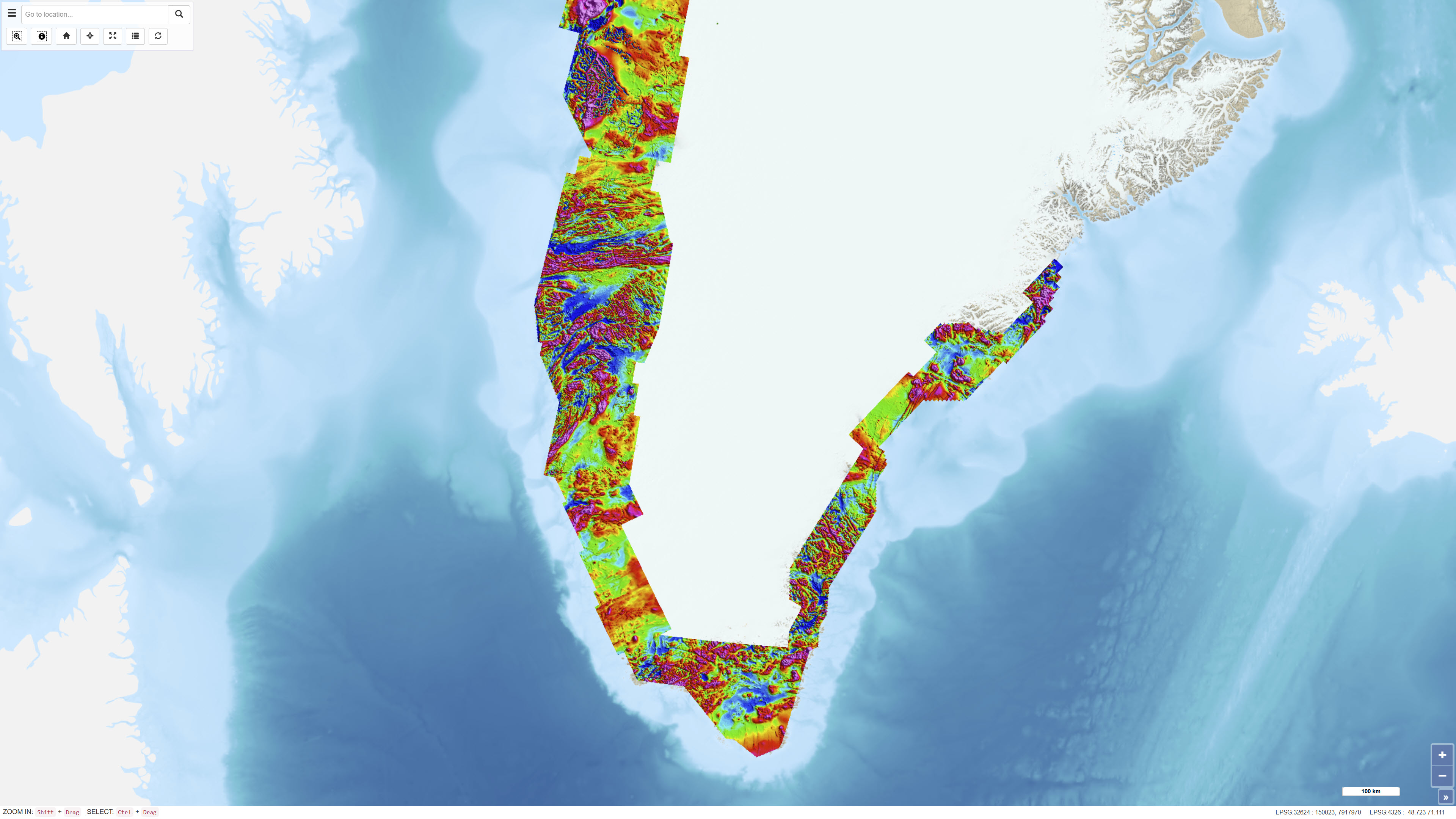
The Regional AEROMAG 1992–2013 Surveys comprise a compilation of high-resolution airborne magnetic surveys acquired by GGU/GEUS between 1993 and 2013 and financed by the Government of Greenland. The overlapping surveys cover approximately 300,000 km² and include the total ice-free onshore areas and near-coastal offshore regions of West Greenland, South Greenland and southern East Greenland. All surveys were acquired using aircraft with similar flight parameters, including line spacings of 500–1,000 m and cross-line spacing of approximately 5,000 m, and with flight altitudes of about 300 m above ground level or seafloor along gently draped surfaces. These consistent acquisition parameters allow the individual surveys to be integrated into a coherent, high-quality regional magnetic data compilation. The total magnetic anomaly map was generated by merging grids from separately processed datasets using the grid-knitting module in Oasis Montaj. The data are IGRF-corrected but not reduced to the pole, and the crustal magnetic field model MF7 was used as a regional reference grid during compilation.