 Arctic SDI catalogue
Statistical analysis
Type of resources
Available actions
Topics
Keywords
Contact for the resource
Provided by
Formats
Representation types
Update frequencies
status
-
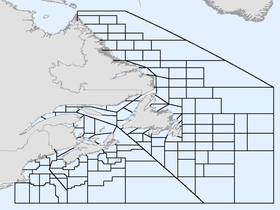
Fisheries and Oceans Canada (DFO) statistical unit areas (also referred to as unit areas) are smaller portions of the Northwest Atlantic Fisheries Organization (NAFO) Subareas, Divisions, and Subdivisions defined in the Convention on Cooperation in the Northwest Atlantic Fisheries (2020). The spatial representation of boundaries defined by NAFO has recently been updated to address inconsistencies and errors in earlier versions, which is available here: https://open.canada.ca/data/dataset/59af1c96-fc8f-4fa0-b398-d65e953eadaa#comment-41855. Unit areas are used by DFO for a variety of purposes including, but not limited to stock assessments, privacy screening of fisheries maps, and statistical analyses. Unit areas were originally defined throughout the 1940s and 1950s. Subsequently, several revisions and alternate versions were created by DFO in various regions leading to inconsistencies in spatial extent and naming conventions. These changes have not been formally documented. The datasets often have topological errors such as gaps and overlaps, especially along diagonals and coastlines. In addition, inconsistencies have arisen from conflicting interpretations of the NAFO divisions, where not all land points are defined by coordinates. Therefore, DFO, with input from the Canadian Hydrographic Service (CHS), has created an updated version of the DFO unit areas file to address inconsistencies and errors among previous versions. The recently updated NAFO divisions were used as the basis for an updated DFO unit areas file. This version of the DFO unit areas must not be used for legal purposes. Legal descriptions of fishing area boundaries can be found in the Atlantic Fisheries Regulations, Maritime Provinces Fishery Regulations, and DFO License Conditions.
-
Environment and Climate Change Canada’s (ECCC) Climate Research Division (CRD) and the Pacific Climate Impacts Consortium (PCIC) previously produced statistically downscaled climate scenarios based on simulations from climate models that participated in the Coupled Model Intercomparison Project phase 5 (CMIP5) in 2015. ECCC and PCIC have now updated the CMIP5-based downscaled scenarios with two new sets of downscaled scenarios based on the next generation of climate projections from the Coupled Model Intercomparison Project phase 6 (CMIP6). The scenarios are named Canadian Downscaled Climate Scenarios–Univariate method from CMIP6 (CanDCS-U6) and Canadian Downscaled Climate Scenarios–Multivariate method from CMIP6 (CanDCS-M6). CMIP6 climate projections are based on both updated global climate models and new emissions scenarios called “Shared Socioeconomic Pathways” (SSPs). Statistically downscaled datasets have been produced from 26 CMIP6 global climate models (GCMs) under three different emission scenarios (i.e., SSP1-2.6, SSP2-4.5, and SSP5-8.5), with PCIC later adding SSP3-7.0 to the CanDCS-M6 dataset. The CanDCS-U6 was downscaled using the Bias Correction/Constructed Analogues with Quantile mapping version 2 (BCCAQv2) procedure, and the CanDCS-M6 was downscaled using the N-dimensional Multivariate Bias Correction (MBCn) method. The CanDCS-U6 dataset was produced using the same downscaling target data (NRCANmet) as the CMIP5-based downscaled scenarios, while the CanDCS-M6 dataset implements a new target dataset (ANUSPLIN and PNWNAmet blended dataset). Statistically downscaled individual model output and ensembles are available for download. Downscaled climate indices are available across Canada at 10km grid spatial resolution for the 1950-2014 historical period and for the 2015-2100 period following each of the three emission scenarios. A total of 31 climate indices have been calculated using the CanDCS-U6 and CanDCS-M6 datasets. The climate indices include 27 Climdex indices established by the Expert Team on Climate Change Detection and Indices (ETCCDI) and 4 additional indices that are slightly modified from the Climdex indices. These indices are calculated from daily precipitation and temperature values from the downscaled simulations and are available at annual or monthly temporal resolution, depending on the index. Monthly indices are also available in seasonal and annual versions. Note: projected future changes by statistically downscaled products are not necessarily more credible than those by the underlying climate model outputs. In many cases, especially for absolute threshold-based indices, projections based on downscaled data have a smaller spread because of the removal of model biases. However, this is not the case for all indices. Downscaling from GCM resolution to the fine resolution needed for impacts assessment increases the level of spatial detail and temporal variability to better match observations. Since these adjustments are GCM dependent, the resulting indices could have a wider spread when computed from downscaled data as compared to those directly computed from GCM output. In the latter case, it is not the downscaling procedure that makes future projection more uncertain; rather, it is indicative of higher variability associated with finer spatial scale. Individual model datasets and all related derived products are subject to the terms of use (https://pcmdi.llnl.gov/CMIP6/TermsOfUse/TermsOfUse6-1.html) of the source organization.
-
Environment and Climate Change Canada’s (ECCC) Climate Research Division (CRD) and the Pacific Climate Impacts Consortium (PCIC) previously produced statistically downscaled climate scenarios based on simulations from climate models that participated in the Coupled Model Intercomparison Project phase 5 (CMIP5) in 2015. ECCC and PCIC have now updated the CMIP5-based downscaled scenarios with two new sets of downscaled scenarios based on the next generation of climate projections from the Coupled Model Intercomparison Project phase 6 (CMIP6). The scenarios are named Canadian Downscaled Climate Scenarios–Univariate method from CMIP6 (CanDCS-U6) and Canadian Downscaled Climate Scenarios–Multivariate method from CMIP6 (CanDCS-M6). CMIP6 climate projections are based on both updated global climate models and new emissions scenarios called “Shared Socioeconomic Pathways” (SSPs). Statistically downscaled datasets have been produced from 26 CMIP6 global climate models (GCMs) under three different emission scenarios (i.e., SSP1-2.6, SSP2-4.5, and SSP5-8.5), with PCIC later adding SSP3-7.0 to the CanDCS-M6 dataset. The CanDCS-U6 was downscaled using the Bias Correction/Constructed Analogues with Quantile mapping version 2 (BCCAQv2) procedure, and CanDCS-M6 was downscaled using the N-dimensional Multivariate Bias Correction (MBCn) method. The CanDCS-U6 dataset was produced using the same downscaling target data (NRCANmet) as the CMIP5-based downscaled scenarios, while the CanDCS-M6 dataset implements a new target dataset (ANUSPLIN and PNWNAmet blended dataset). Statistically downscaled individual model output and ensembles are available for download. Downscaled climate indices are available across Canada at 10km grid spatial resolution for the 1950-2014 historical period and for the 2015-2100 period following each of the three emission scenarios. Note: projected future changes by statistically downscaled products are not necessarily more credible than those by the underlying climate model outputs. In many cases, especially for absolute threshold-based indices, projections based on downscaled data have a smaller spread because of the removal of model biases. However, this is not the case for all indices. Downscaling from GCM resolution to the fine resolution needed for impacts assessment increases the level of spatial detail and temporal variability to better match observations. Since these adjustments are GCM dependent, the resulting indices could have a wider spread when computed from downscaled data as compared to those directly computed from GCM output. In the latter case, it is not the downscaling procedure that makes future projection more uncertain; rather, it is indicative of higher variability associated with finer spatial scale. Individual model datasets and all related derived products are subject to the terms of use (https://pcmdi.llnl.gov/CMIP6/TermsOfUse/TermsOfUse6-1.html) of the source organization.
-
Environment and Climate Change Canada’s (ECCC) CMIP6 statistically downscaled agroclimatic indices are an updated version of the CMIP5 agroclimatic indices dataset making use of two different sets of downscaled scenarios created by the Pacific Climate Impacts Consortium (PCIC): 1. Canadian Downscaled Climate Scenarios–Univariate method from CMIP6 (CanDCS-U6), and 2. Canadian Downscaled Climate Scenarios–Multivariate method from CMIP6 (CanDCS-M6). To address the needs of different user groups in Canada, 49 indices, including agroclimatic indices, were proposed by the Canadian adaptation community through a series of consultations. Please see the definition list for the equations of each index. In 2025, PCIC expanded the CMIP6 agroclimatic indices, by adding CanDCS-M6, which includes SSP3-7.0 for most GCMs. Additionally, PCIC introduced 18 new indices to the previous 49. The 67 indices are available for both the CanDCS-U6 and CanDCS-M6. The range of impact-relevant climate indices available for download includes, indices representing counts of the number of days when temperature or precipitation exceeds (or is below) a threshold value; the episode length when a particular weather/climate condition occurs; and indices that accumulate temperature departures above or below a fixed threshold. The statistically downscaled climate indices are available for individual models and ensembles, historical simulations (1951-2014) and three emissions scenarios called “Shared Socioeconomic Pathways” (SSPs), SSP1-2.6, SSP2-4.5, and SSP5-8.5 (2015-2100), at a 10 x 10 km degree grid resolution. The CanDCS-M6 agroclimatic indices dataset also includes SSP3-7.0 results. Note: projected future changes by statistically downscaled products are not necessarily more credible than those by the underlying climate model outputs. In many cases, especially for absolute threshold-based indices, projections based on downscaled data have a smaller spread because of the removal of model biases. However, this is not the case for all indices. Downscaling from GCM resolution to the fine resolution needed for impact assessment increases the level of spatial detail and temporal variability to better match observations. Since these adjustments are GCM dependent, the resulting indices could have a wider spread when computed from downscaled data as compared to those directly computed from GCM output. In the latter case, it is not the downscaling procedure that makes future projection more uncertain; rather, it is indicative of higher variability associated with a finer spatial scale. Individual model datasets and all related derived products are subject to the terms of use (https://pcmdi.llnl.gov/CMIP6/TermsOfUse/TermsOfUse6-1.html) of the source organization.