 Arctic SDI catalogue
nord
Type of resources
Keywords
Contact for the resource
Provided by
Years
Representation types
Update frequencies
status
Service types
-
The 1 cm resolution vegetation digital height model was extracted using a bare earth model and digital surface model (DSM) derived from unmanned aerial vehicle (UAV) imagery acquired from a single day survey on July 28th 2016, in Cambridge Bay, Nunavut. The mapping product covers 525m2 and was produced by Canada Centre for Remote Sensing /Canada Centre for Mapping and Earth Observation. The UAV survey was completed in collaboration with the Canadian High Arctic Research Station (CHARS) for northern vegetation monitoring research. For more information, refer to our current Arctic vegetation research: Fraser et al; "UAV photogrammetry for mapping vegetation in the low-Arctic" Arctic Science, 2016, 2(3): 79-102. http://www.nrcresearchpress.com/doi/abs/10.1139/AS-2016-0008
-

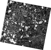
The 1 cm resolution digital surface model (DSM) was created from unmanned aerial vehicle (UAV) imagery acquired from a single day survey, July 28th 2016, in Cambridge Bay, Nunavut. Five control points taken from a Global Differential Positioning System were positioned in the corners and the center of the vegetation survey. The DSM covering 525m2 was produced by Canada Centre for Remote Sensing /Canada Centre for Mapping and Earth Observation. The UAV survey was completed in collaboration with the Canadian High Arctic Research Station (CHARS) for northern vegetation monitoring research. For more information, refer to our current Arctic vegetation research: Fraser et al; "UAV photogrammetry for mapping vegetation in the low-Arctic" Arctic Science, 2016, 2(3): 79-102. http://www.nrcresearchpress.com/doi/abs/10.1139/AS-2016-0008
-
La donnée a été créée ou dérivée à partir d'images de véhicules aériens non habités (UAV) acquises à partir d'une enquête d'une journée, le 28 juillet 2016, à Cambridge Bay, au Nunavut. Cinq points de contrôle provenant d'un système de positionnement différentiel global ont été positionnés dans les coins et au centre de l'étude de la végétation. Les jeux de données suivants couvrent une superficie de 525m2 et ont été produits par le Centre canadien de télédétection / Centre canadien de cartographie et d'observation de la Terre: - UAV modèle d'hauteur de la végétation, Cambridge Bay, Nunavut - UAV modèle numérique de surface (MNS) dans Cambridge Bay, Nunavut - Parcelle de végétation - UAV orthomosaïque de Cambridge Bay, Nunavut - Parcelle de végétation L'enquête sur les UAV a été menée en collaboration avec La Station canadienne de recherche dans l’Extrême-Arctique (SCREA) pour la recherche sur la surveillance de la végétation nordique. Pour plus de renseignement, consultez nos travaux de recherche actuels: Fraser et al; ""UAV photogrammetry for mapping vegetation in the low-Arctic"" Arctic Science, 2016, 2(3): 79-102, 10.1139/as-2016-0008 http://www.nrcresearchpress.com/doi/abs/10.1139/AS-2016-0008
-
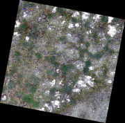
The 0.34 cm resolution orthomosaic was created from unmanned aerial vehicle (UAV) imagery acquired from a single day survey, July 28th 2016, in Cambridge Bay, Nunavut. Five control points taken from a Global Differential Positioning System were positioned in the corners and the center of the vegetation survey. The orthomosaic covering 525m2 was produced by Canada Centre for Remote Sensing /Canada Centre for Mapping and Earth Observation. The UAV survey was completed in collaboration with the Canadian High Arctic Research Station (CHARS) for northern vegetation monitoring research. For more information, refer to our current Arctic vegetation research: Fraser et al; "UAV photogrammetry for mapping vegetation in the low-Arctic" Arctic Science, 2016, 2(3): 79-102. http://www.nrcresearchpress.com/doi/abs/10.1139/AS-2016-0008.