 Arctic SDI catalogue
Hyas coarctatus
Type of resources
Topics
Keywords
Contact for the resource
Provided by
Formats
Representation types
Update frequencies
status
-

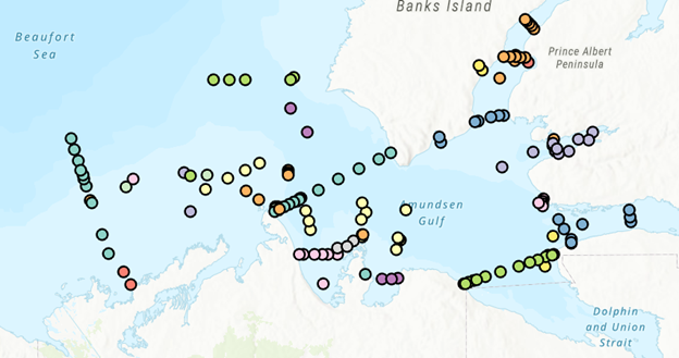
Summary The Quebec region of the Department of Fisheries and Oceans (DFO) is responsible for the assessment of several fish and invertebrate stocks exploited in the Estuary and the northern Gulf of St. Lawrence. The commercial catches sampling program is one of the sources of information used to complete these assessments. The data collected by this program, at wharf or at sea, offers among other things the advantage of a relatively large spatio-temporal coverage and provides some of the necessary knowledge to assess the demography and the structure of the exploited populations. This program is implemented by specialized DFO staff whose main mandate is to collect biological data on groundfish, pelagic fish and marine invertebrate species that are commercially exploited in the various marine communities. Data This dataset on the Arctic Lyre Crab (Hyas coarctatus) includes the metadata, sample weight, specimen weight, the shell width, the shell state, the height of the right claw and sex. This dataset covers the period between 2002-2021. In order to protect the confidentiality of the sources, some informations (such as those concerning the vessel) have been excluded and others (such as the date of capture) have been simplified. Entries where there was only one vessel in a fishing area for a given year were also excluded. Further information including the fishing areas coordinates can be found by clicking on the «Atlantic and Arctic commercial fisheries» and «Fishing areas» links below.
-

From August 5th to September 3rd, 2012, Fisheries and Oceans Canada conducted a baseline survey of marine fishes and their habitats on the Canadian Beaufort Shelf and slope. Sampling was conducted from the F/V Frosti at 28 stations along four transects. Standardized sampling was conducted at pre-determined depth stations (20-40, 75, 200, 350, 500, 750, and 1000 m) using a variety of sampling equipment including benthic fishing trawls, plankton nets, sediment cores, and CTD and water sample profiles. A specialized CTD probe (UCTD) was deployed at an additional 30 locations while the ship was underway. Presented here is the information on the sampling locations, and the sampling gear deployed at each station.
-

From August 2nd to September 9th, 2013, Fisheries and Oceans Canada conducted a baseline survey of marine fishes and their habitats on the Canadian Beaufort Shelf and slope. Sampling was conducted from the F/V Frosti at 64 stations along ten transects. Standardized sampling was conducted on the transects at pre-determined depth stations (20-40, 75, 200, 350, 500, 750, and 1000 m) using a variety of sampling equipment including benthic fishing trawls, plankton nets, sediment cores, and CTD and water sample profiles. A specialized CTD probe (UCTD) was deployed at an additional 72 locations while the ship was underway.Presented here is the information on the sampling locations, and the sampling gear deployed at each station.
-
PURPOSE: The Department of Fisheries and Oceans (DFO) conducted a baseline survey of biological communities and habitat parameters in the offshore Canadian Beaufort Sea between 2012 and 2014, as part of the federally administered Beaufort Regional Environmental Assessment. The BREA-Marine Fishes Project (BREA-MFP) was the first comprehensive baseline study of offshore marine fish diversity and associated habitats in the Canadian Beaufort Sea. Knowledge gained during the BREA-MFP supports regulatory processes pertaining to offshore development and Oceans Management in the Inuvialuit Settlement Region, and provides baseline context for studies of the effects of climate change and variability. The Canadian Beaufort Sea – Marine Ecosystem Assessment (CBS-MEA, 2017-2019 and 2021-2024) is building on system baselines and ecological knowledge derived from the BREA-MFP to develop a comprehensive research and monitoring approach for the offshore Canadian Beaufort Sea. This approach will enable us to better understand the relationship between oceanographic drivers and ecosystem responses. The CBS-MEA focuses on integrating oceanography, food web linkages, physical-biological couplings and spatial and inter-annual variabilities, while also expanding baseline coverage of species diversity, abundances, and habitat associations to areas of the Beaufort Sea and Canadian Archipelago that are previously unstudied in this context. DESCRIPTION: Between 2017 and 2019, and between 2021 and 2024, Fisheries and Oceans Canada conducted a baseline survey of marine fishes and their habitats on the Canadian Beaufort Shelf and slope in August and early September each year. Sampling was conducted from the F/V Frosti at over 150 stations along ten multi-year transects, and over 50 non-transect stations. Standardized sampling was conducted at pre-determined depth stations (20-40, 75, 200, 350, 500, 750, and 1000 m) using a variety of sampling equipment including benthic fishing trawls, plankton nets, sediment cores, and CTD and water sample profiles. Presented here is the information on the sampling locations, and the sampling gear deployed at each station.
-

From August 6th to September 9th, 2014, Fisheries and Oceans Canada conducted a baseline survey of marine fishes and their habitats on the Canadian Beaufort Shelf and slope. Sampling was conducted from the F/V Frosti at 56 stations along thirteen transects, with an additional three stations not located on transects. Standardized sampling was conducted on the transects at pre-determined depth stations (20-40, 75, 200, 350, 500, 750, and 1000 m) using a variety of sampling equipment including benthic fishing trawls, plankton nets, sediment cores, and CTD and water sample profiles. Presented here is the information on the sampling locations, and the sampling gear deployed at each station.