 Arctic SDI catalogue
LCC
Type of resources
Available actions
Keywords
Contact for the resource
Provided by
Years
Service types
-
The Canada Base Map - Elevation(CBME) web mapping services of the Earth Sciences Sector at Natural Resources Canada, is intended primarily for online mapping application users and developers. This service is available only in Lambert Conformal Conic (ESPG:3978) projection. This service can be accessed at no cost and without restrictions according to the terms of the license at http://geogratis.cgdi.gc.ca/geogratis/en/licence.jsp. This hillshade service have been created to provide some relief context over which thematic information can be overlaid. The range of viewing scales for this service is between 1:145,000,000 and 1:17,500. Features from the following datasets are used by the CBME service: CDEM. La Carte de Base du Canada – Élevation (CBCE) du Secteur des sciences de la Terre de Ressources naturelles Canada est un service Internet qui s'adresse principalement aux utilisateurs et développeurs d'applications cartographiques en ligne. Ce service est disponible seulement en projection conique conforme de Lambert ( ESPG : 3978 ). Ce service est accessible sans frais et sans restrictions selon les termes de la licence à http://geogratis.cgdi.gc.ca/geogratis/fr/licence.jsp. Ce service de relief ombré a été créé pour fournir un contexte de relief sur lequel des informations thématiques peuvent être superposées . La gamme de visualisation des échelles pour ce service est compris entre 1 : 145.000.000 et 1 : 17.500. Le jeu de données suivants a été utilisé par la CBCE : MNEC.
-
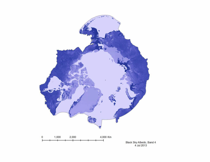
Albedo is a reflection coefficient that describes the reflecting power of a surface. Data compiled for CAFFs Land Cover Change Initiative with dataset for the firs of very month during 2001- 20112. - <a href="http://www.caff.is/indices-and-indicators/land-cover-change-index" target="_blank"> Land Cover Change Initiative (LCC)</a>
-
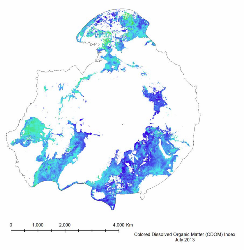
Colored Dissolved Organic Matter (CDOM) is a measurement of the absorption of light in the UV and visible spectrum by the colored components of dissolved organic carbon. It is essentially the yellow substance in water as a result of decaying detritus. It is important to measure because it limits the amount of sunlight penetration, and thus restricts the growth of plankton populations. It is measured in a unit-less CDOM index. Data generated as part of CAFFs Circumpolar Biodiversity Monitoring Program (CAFF) and its Land Cover Change Initiative (LCC) Trends visible in the MODIS dataset show an overall decrease in the mean CDOM from 2003 to 2012, with a percent change of -31.7%. This trend can be seen in Figure 40. This decrease corresponds to the increase in total yearly primary productivity (Figure 30), as a decrease in the CDOM allows for sunlight to penetrate deeper into the water, boosting chlorophyll concentrations and thus primary productivity.
-
CBMT EN The Canada Base Map - Transportation (CBMT). This web mapping service provides spatial reference context with an emphasis on transportation networks. It is designed especially for use as a background map in a web mapping application or geographic information system (GIS). Access is free of charge under the terms of the following licence: Open Government Licence – Canada - http://open.canada.ca/en/open-government-licence-canada. Its data source is the CanVec product which is available on Open Government web site with title Topographic data of Canada - CanVec Series (http://open.canada.ca/data/en/dataset/8ba2aa2a-7bb9-4448-b4d7-f164409fe056).