 Arctic SDI catalogue
Russia
Type of resources
Available actions
Keywords
Contact for the resource
Provided by
Years
Service types
-
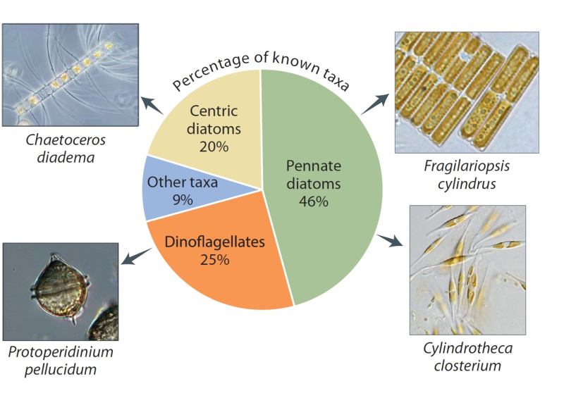
The number of species depends partly on what has been studied. Proportions vary somewhat around the Arctic, but diatoms and dinoflagellates are the most diverse groups everywhere. The greatest sampling effort has been in the Laptev Sea, Hudson Bay, and the Norwegian sector of the Barents Sea. Species shown are among the most commonly recorded. Published in the Life Linked to Ice released in 2013, page 26. Life Linked to Ice: A guide to sea-ice-associated biodiversity in this time of rapid change. CAFF Assessment Series No. 10. Conservation of Arctic Flora and Fauna, Iceland. ISBN: 978-9935-431-25-7.
-
This server is part of the Siberian Earth System Science Cluster (SIB-ESS-C) and provides OGC Web Feature Services (WFS) of derived data products originating either from joint research projects coordinated by Friedrich-Schiller-University, Dept. for Earth Observation or data being provided to us for publication on this server. In cases where the Friedrich-Schiller-University is not the creator of the data product, credit should be given to the original creator when using the data. Some datasets may be restricted to internal use.
-
VSEGEI, Bedrock geology of Russia
-
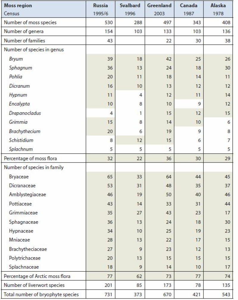
Arctic Biodiversity Assessment (ABA) 2013. Table 9.5. Species numbers of species-rich moss genera and families. Numbers highlighted in grey fields are used in calculating the percentage of the total moss flora. Listed are Splachnum, genera with at least 10 species and families with at least nine species. Conservation of Arctic Flora and Fauna, CAFF 2013 - Akureyri . Arctic Biodiversity Assessment. Status and Trends in Arctic biodiversity. - Plants(Chapter 9) page 333
-
This worldwide street map presents highway-level data for the world. Street-level data includes the United States; much of Canada; Mexico; Europe; Japan; Australia and New Zealand; India; South America and Central America; Africa; and most of the Middle East. This comprehensive street map includes highways, major roads, minor roads, one-way arrow indicators, railways, water features, administrative boundaries, cities, parks, and landmarks, overlaid on shaded relief imagery for added context. The map also includes building footprints for selected areas. Coverage is provided down to ~1:4k with ~1:1k and ~1:2k data available in select urban areas. The street map was developed by Esri using Esri basemap data, Garmin basemap layers, U.S. Geological Survey (USGS) elevation data, Intact Forest Landscape (IFL) data for the world; HERE data for Europe, Australia and New Zealand, North America, South America and Central America, Africa, India, and most of the Middle East; OpenStreetMap contributors for select countries in Africa and Pacific Islands; NGCC data for China; and select data from the GIS user community. For more information on this map, including the terms of use, visit us <a href="http://goto.arcgisonline.com/maps/World_Street_Map " target="_new" >online</a>.