 Arctic SDI catalogue
Switzerland
Type of resources
Available actions
Topics
Keywords
Contact for the resource
Provided by
Years
Formats
Service types
Resolution
-
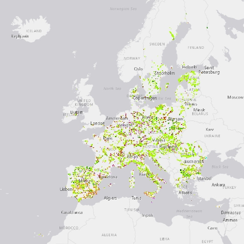
This metadata refers to the CLMS N2K Change 2012-2018 product, the Copernicus Land Cover/Land Use (LC/LU) change map tailored to the needs of biodiversity monitoring in selected Natura2000 sites: 4790 sites of natural and semi-natural grassland formations listed in Annex I of the Habitats Directive, including a 2km buffer zone surrounding the sites. The change mapping exercise between the reference years 2012 and 2018, was based on the comparison of VHR satellite data and occurred over an area of 631.800 km² across Europe (i.e. EU27, the United Kingdom and Switzerland). The change dataset only shows the areas that have changed between 2012 and 2018 and covers an area of 1.199.652 ha. LC/LU is extracted from VHR satellite data and other available data. Change detection is based on the analysis of VHR satellite data from the reference years 2012 ±2 years and 2018 ±1 year. The production of N2K updates was coordinated by the European Environment Agency (EEA) in the frame of the EU Copernicus programme.
-
This metadata refers to the CLMS N2K Change 2006-2012 product, the Copernicus Land Cover/Land Use (LC/LU) change map tailored to the needs of biodiversity monitoring in selected Natura2000 sites: 4790 sites of natural and semi-natural grassland formations listed in Annex I of the Habitats Directive, including a 2km buffer zone surrounding the sites. The change mapping exercise between the reference years 2006 and 2012, based on the outputs of the status layers, occurred over an area of 631.800 km² across Europe (i.e. EU27, the United Kingdom and Switzerland). The change dataset only shows the areas that have changed between 2006 and 2012, covering an area of 1.054.684 ha. LC/LU is extracted from VHR satellite data and other available data. Change detection is based on the analysis of VHR satellite data from the reference years 2006 ±2 years and 2012 ±2 years. The production of N2K updates was coordinated by the European Environment Agency (EEA) in the frame of the EU Copernicus programme.
-

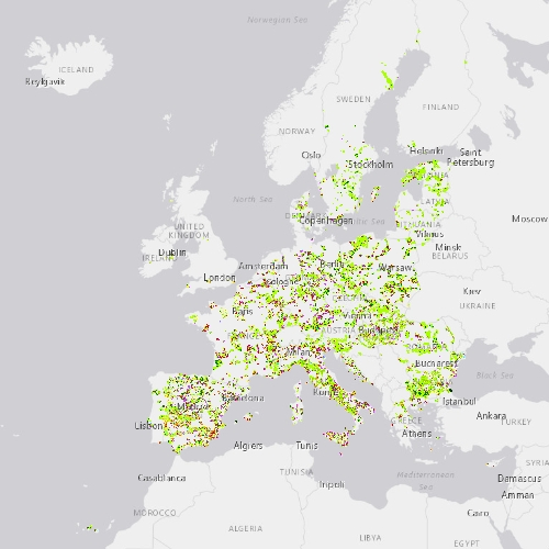
This metadata refers to CLMS N2K 2006 product, the Copernicus Land Cover/Land Use (LC/LU) status map, with 2006 as reference year for the classification, tailored to the needs of biodiversity monitoring in selected Natura2000 sites: 4790 sites of natural and semi-natural grassland formations listed in Annex I of the Habitats Directive, including a 2 km buffer zone surrounding the sites and covering an area of 631.820 km² across Europe (EU27, the United Kingdom and Switzerland). The product includes three Emerald sites in Switzerland. LC/LU has been extracted from VHR satellite data and other available data. This metadata specifically refers to the revision of the 2006 N2K status map carried out during the production of the 2018 update. The production of N2K updates was coordinated by the European Environment Agency (EEA) in the frame of the EU Copernicus programme.
-
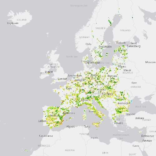
This metadata refers to CLMS N2K 2018 product, the Copernicus Land Cover/Land Use (LC/LU) status map, with 2018 as reference year for the classification, tailored to the needs of biodiversity monitoring in selected Natura2000 sites: 4790 sites of natural and semi-natural grassland formations listed in Annex I of the Habitats Directive, including a 2 km buffer zone surrounding the sites and covering an area of 631.820 km² across Europe (EU27, the United Kingdom and Switzerland). The product includes three Emerald sites in Switzerland. LC/LU has been extracted from VHR satellite data and other available data. The production of N2K updates was coordinated by the European Environment Agency (EEA) in the frame of the EU Copernicus programme.
-

This metadata refers to CLMS N2K 2012 product, the Copernicus Land Cover/Land Use (LC/LU) status map, with 2012 as reference year for the classification, tailored to the needs of biodiversity monitoring in selected Natura2000 sites: 4790 sites of natural and semi-natural grassland formations listed in Annex I of the Habitats Directive, including a 2 km buffer zone surrounding the sites and covering an area of 631.820 km² across Europe (EU27, the United Kingdom and Switzerland). The product includes three Emerald sites in Switzerland. LC/LU has been extracted from VHR satellite data and other available data. This metadata specifically refers to the revision of the 2012 N2K status map carried out during the production of the 2018 update. The production of N2K updates was coordinated by the European Environment Agency (EEA) in the frame of the EU Copernicus programme.
-
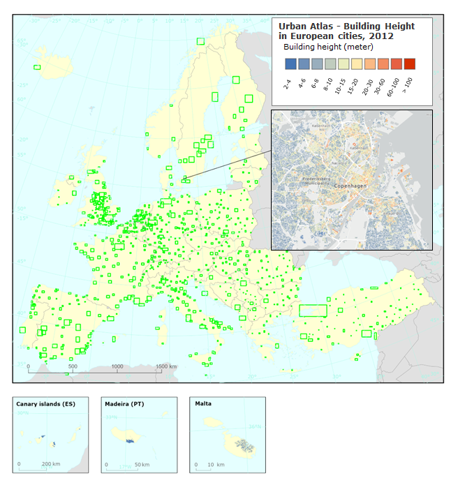
This metadata refers to the Copernicus Building Height 2012 third version. The dataset is a 10m high resolution raster layer containing height information generated for selected cities and urban areas in the EEA38 member countries and United Kingdom as part of the Urban atlas suite of products. Height information is based on satellite data and derived datasets like the digital surface model (DSM), the digital terrain model (DTM) and the normalized DSM. The satellite data sources are IRS-P5 stereo images for the capital cities and VHR false stereo pairs extracted from the MAXAR catalogue (WV-01, WV-02, GE-01 and IK) for the remaining areas supplemented by LiDAR data as additional option.
-
This worldwide street map presents highway-level data for the world. Street-level data includes the United States; much of Canada; Mexico; Europe; Japan; Australia and New Zealand; India; South America and Central America; Africa; and most of the Middle East. This comprehensive street map includes highways, major roads, minor roads, one-way arrow indicators, railways, water features, administrative boundaries, cities, parks, and landmarks, overlaid on shaded relief imagery for added context. The map also includes building footprints for selected areas. Coverage is provided down to ~1:4k with ~1:1k and ~1:2k data available in select urban areas. The street map was developed by Esri using Esri basemap data, Garmin basemap layers, U.S. Geological Survey (USGS) elevation data, Intact Forest Landscape (IFL) data for the world; HERE data for Europe, Australia and New Zealand, North America, South America and Central America, Africa, India, and most of the Middle East; OpenStreetMap contributors for select countries in Africa and Pacific Islands; NGCC data for China; and select data from the GIS user community. For more information on this map, including the terms of use, visit us <a href="http://goto.arcgisonline.com/maps/World_Street_Map " target="_new" >online</a>.