 Arctic SDI catalogue
deciduous tree
Type of resources
Available actions
Topics
Keywords
Contact for the resource
Provided by
Years
Formats
Resolution
-
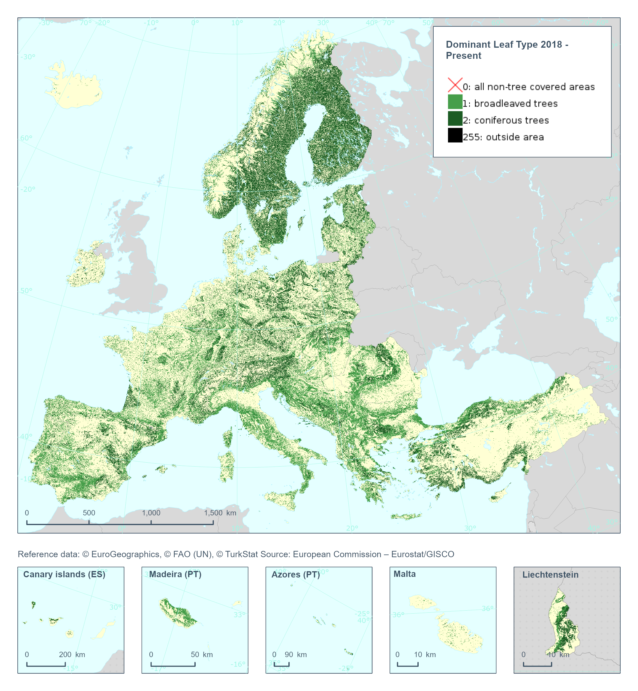
The High Resolution Dominant Leaf Type (DLT) raster product provides a basic land cover classification with 3 thematic classes (all non-tree covered areas, broadleaved and coniferous). This dataset is provided annually starting with 2018 in 10 meter rasters (fully conformant with the EEA reference grid) in 100 x 100 km tiles covering the EEA38 countries. High Resolution Layer Tree Cover and Forest product is part of the European Union’s Copernicus Land Monitoring Service. Confidence layer available for the dataset. This dataset includes data from the French Overseas Territories (DOMs)
-
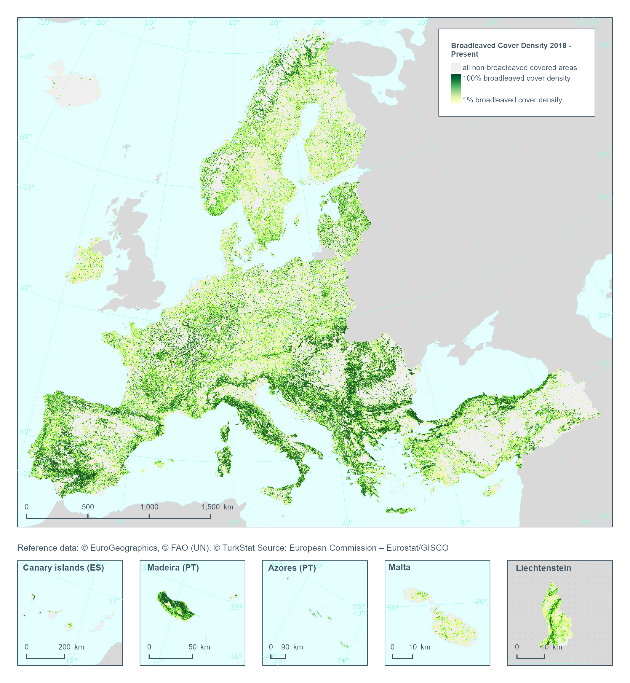
The High Resolution Layer Broadleaved Density (BCD) dataset provides information on the percentage of broadleaved pixels at 100m spatial resolution, and is derived through aggregation of the 10m DLT for the respective reference year. Within each cell the number of broadleaved pixels are counted and the percentages stored into in the 100m pixel of the BCD. The class 255 = outside area is predefined by the 100m boundary layer and remains unchanged. This dataset is provided annually starting with 2018 in 100 meter rasters (fully conformant with the EEA reference grid) in 100 x 100 km tiles covering the EEA38 countries. High Resolution Layer Tree Cover and Forest product is part of the European Union’s Copernicus Land Monitoring Service. This dataset includes data from the French Overseas Territories (DOMs)
-

The High Resolution Layer Forest Type (FTY) provides a forest classification with 3 thematic classes (all non-forest areas / broadleaved forest / coniferous forest) at 10m spatial resolution and with a Minimum Mapping Unit (MMU) of 0.5 ha. This raster layer is largely following the FAO (Food and Agriculture Organisation of the United Nations) forest definition with tree covered areas in agricultural and urban context excluded using the respective Forest Additional Support Layer (FADSL). This dataset is provided on a 3-yearly frequency in 10 meter rasters (fully conformant with the EEA reference grid) in 100 x 100 km tiles covering the EEA38 countries. High Resolution Layer Tree Cover and Forest product is part of the European Union’s Copernicus Land Monitoring Service. This dataset includes data from the French Overseas Territories (DOMs)
-
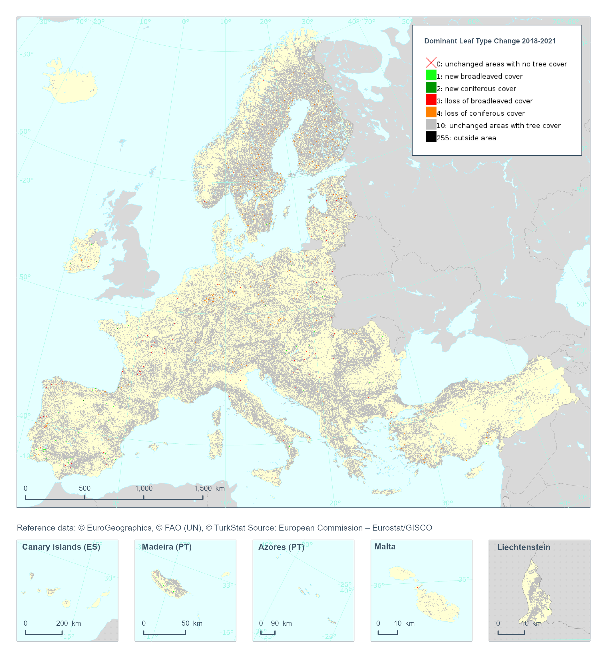
The High Resolution Layer Dominant Leaf Type Change (DLTC) 2018-2021 raster product provides information on the change between the reference years 2018 and 2021 and consists of 7 thematic classes (unchanged areas with no tree cover / new broadleaved cover / new coniferous cover / loss of broadleaved cover / loss of coniferous cover / unchanged areas with tree cover / potential change among dominant leaf types). This dataset is provided in 20 meter rasters (fully conformant with the EEA reference grid) in 100 x 100 km tiles covering the EEA38 countries. The production of the high resolution forest layers was coordinated by the European Environment Agency (EEA) in the frame of the EU Copernicus programme. This dataset includes data from the French Overseas Territories (DOMs)
-

The High Resolution Layer Forest Type (FTY) dataset provides the Forest Type estimation at 100 meter spatial resolution. The number of broadleaved and coniferous pixels are counted and the percentages stored in the 100m cell. The class 255 = outside area is predefined by the 100m boundary layer and remains unchanged. This dataset is provided on a 3-yearly frequency in 100 meter rasters (fully conformant with the EEA reference grid) in 100 x 100 km tiles covering the EEA38 countries. High Resolution Layer Tree Cover and Forest product is part of the European Union’s Copernicus Land Monitoring Service. This dataset includes data from the French Overseas Territories (DOMs)