 Arctic SDI catalogue
European
Type of resources
Available actions
Topics
Keywords
Contact for the resource
Provided by
Years
Formats
Scale
Resolution
-
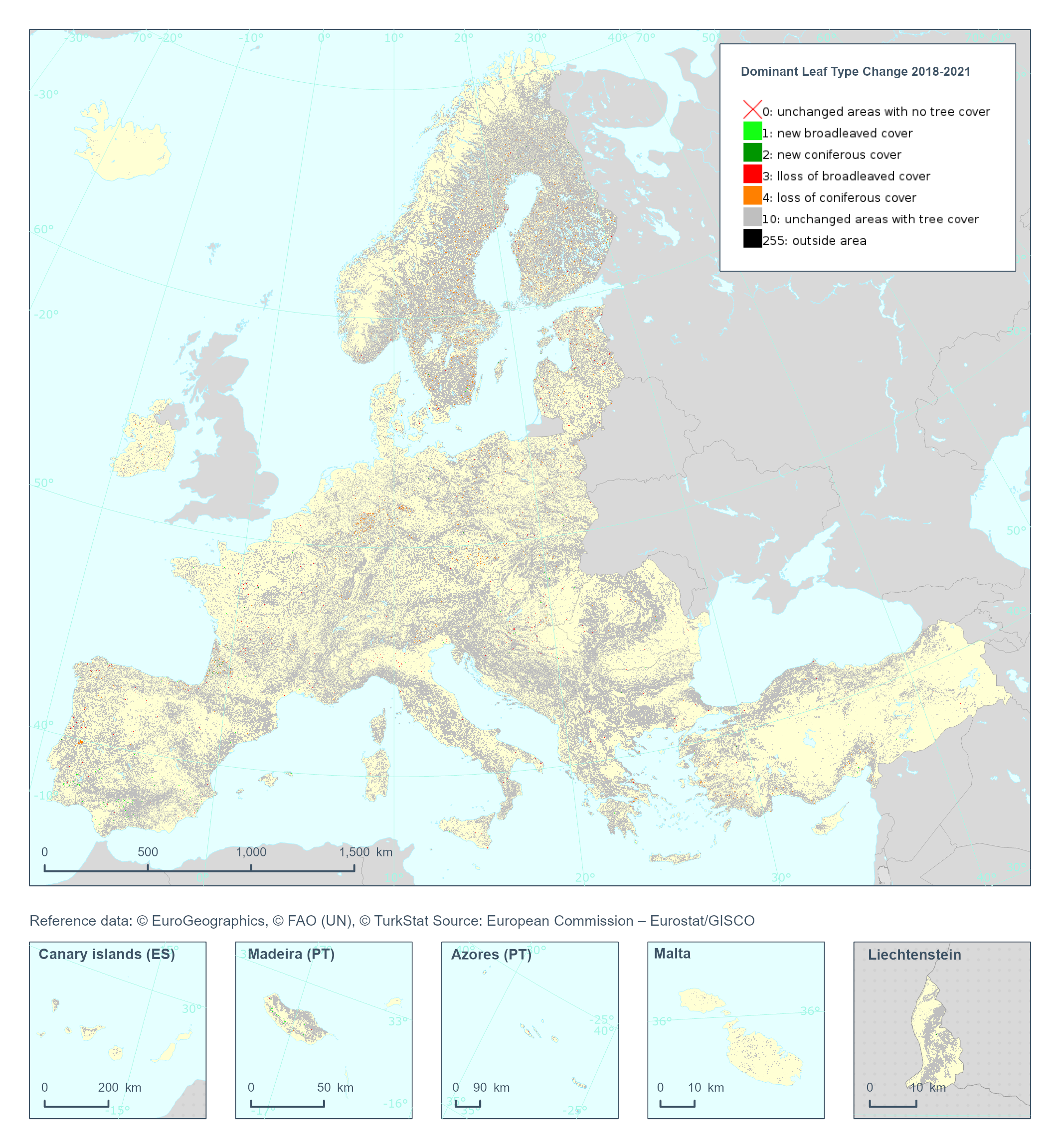
The High Resolution Layer Dominant Leaf Type Change (DLTC) 2018-2021 raster product provides information on the change between the reference years 2018 and 2021 and consists of 7 thematic classes (unchanged areas with no tree cover / new broadleaved cover / new coniferous cover / loss of broadleaved cover / loss of coniferous cover / unchanged areas with tree cover / potential change among dominant leaf types). This dataset is provided in 20 meter rasters (fully conformant with the EEA reference grid) in 100 x 100 km tiles covering the EEA38 countries. The production of the high resolution forest layers was coordinated by the European Environment Agency (EEA) in the frame of the EU Copernicus programme. This dataset includes data from the French Overseas Territories (DOMs)
-
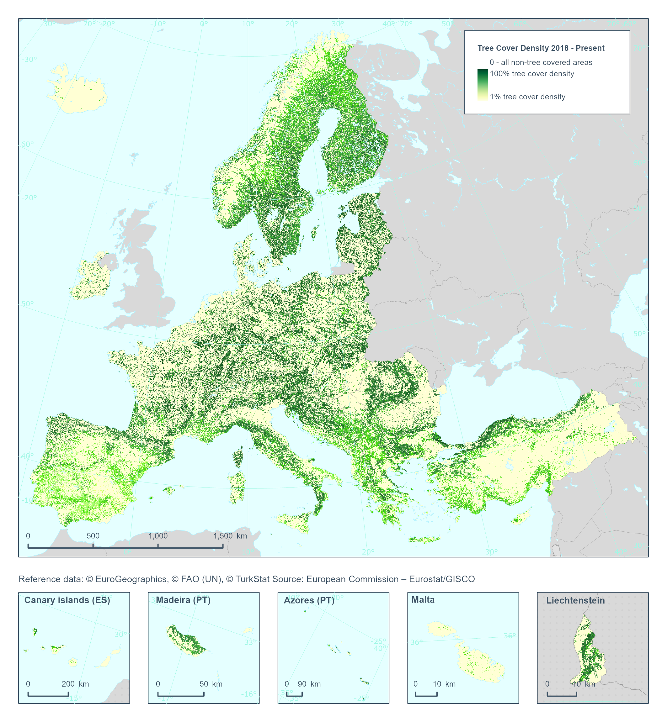
The High Resolution Layer Tree Cover Density (TCD) dataset provides information on the proportional crown coverage per pixel at 100 meter spatial resolution and ranges from 0% (all non-tree covered areas) to 100%, whereby Tree Cover Density is defined as the "vertical projection of tree crowns to a horizontal earth’s surface“. This product is an aggregation of its corresponding high resolution dataset. This dataset is provided annually starting with 2018 in 100 meter rasters (fully conformant with the EEA reference grid) in 100 x 100 km tiles covering the EEA38 countries. High Resolution Layer Tree Cover and Forest product is part of the European Union’s Copernicus Land Monitoring Service.
-
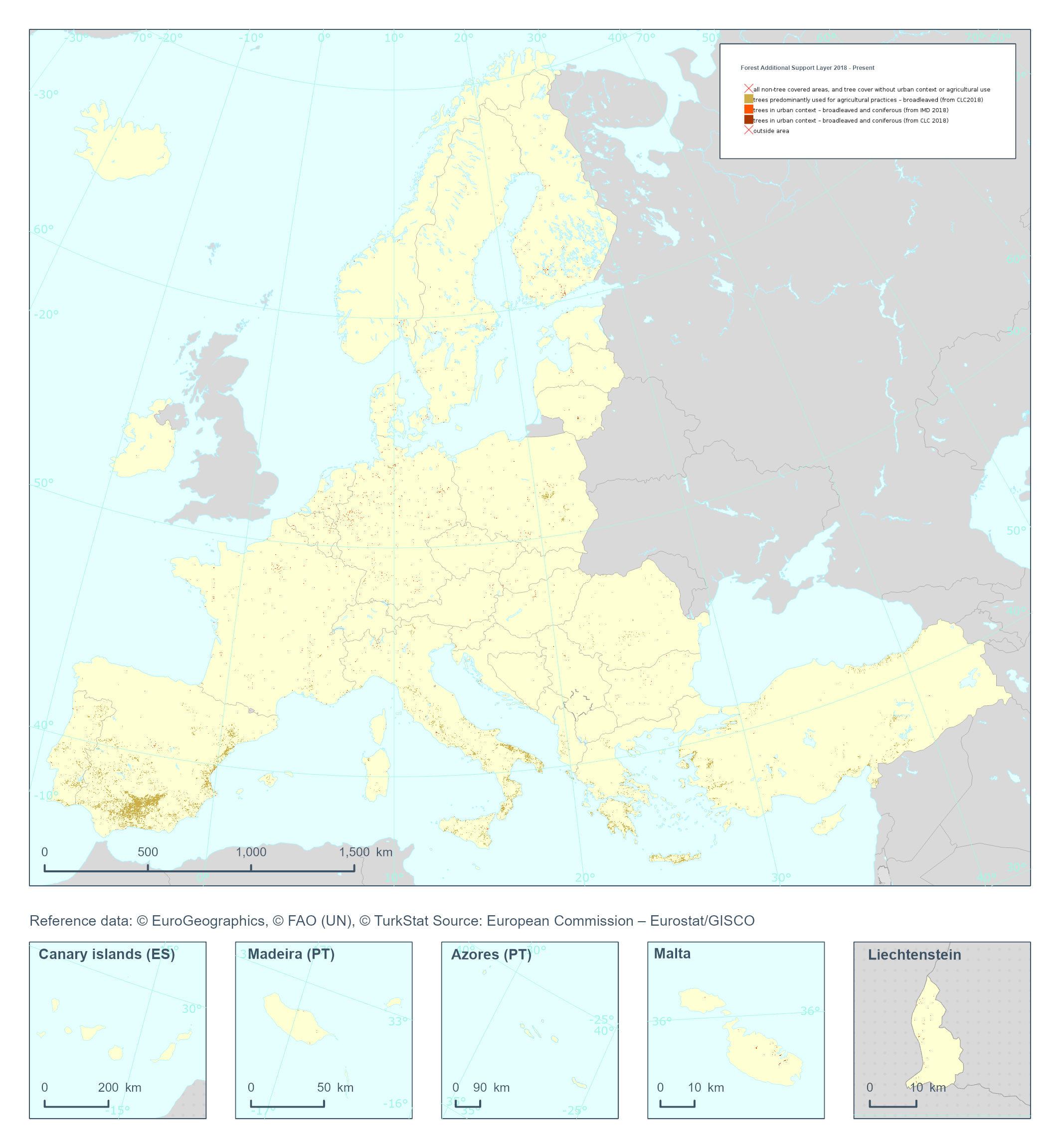
The High Resolution Layer Forest Additional Support Layer (FADSL) provides information on trees under agricultural use or in urban context to be excluded from the Forest Type (FTY) product and at 10m spatial resolution. The derivation of Forest Additional Support Layer (FADSL) is based on the spatial intersection of the 10m DLT and TCD layers with CORINE Land Cover (CLC) 2018 and HRL Imperviousness Degree 2018 with 10 m spatial resolution; TCD range of ≥ 10-100%; with a MMW of 10m and no MMU (pixel base). This dataset is provided on a 3-yearly frequency in 10 meter rasters (fully conformant with the EEA reference grid) in 100 x 100 km tiles covering the EEA38 countries. High Resolution Layer Tree Cover and Forest product is part of the European Union’s Copernicus Land Monitoring Service. This dataset includes data from the French Overseas Territories (DOMs)
-
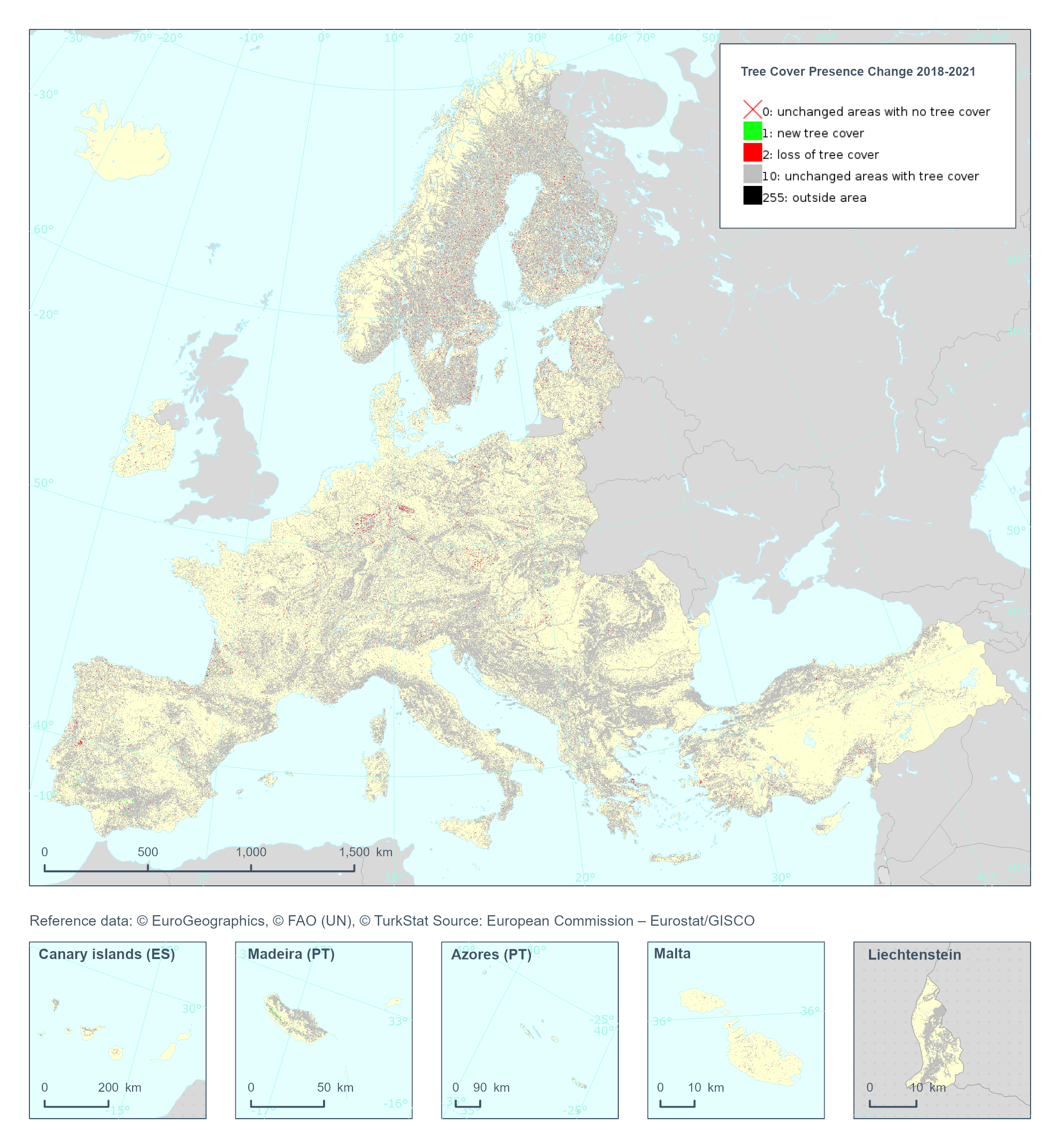
The Copernicus High Resolution Layer Tree Cover Precense Change (TCPC) 2018-2021 raster product provides information on the change between the reference years 2018 and 2021 and consists of 4 thematic classes (unchanged areas with no tree cover / new tree cover / loss of tree cover / unchanged areas with tree cover). The class 255 = outside area is predefined by the 100m boundary layer and remains unchanged. This layer for previous reference year compraissions is called Tree Cover Change Mask (TCCM). This dataset is provided in 20 meter rasters (fully conformant with the EEA reference grid) in 100 x 100 km tiles covering the EEA38 countries. The production of the high resolution forest layers was coordinated by the European Environment Agency (EEA) in the frame of the EU Copernicus programme. Confidence layer available for the dataset. This dataset includes data from the French Overseas Territories (DOMs)
-

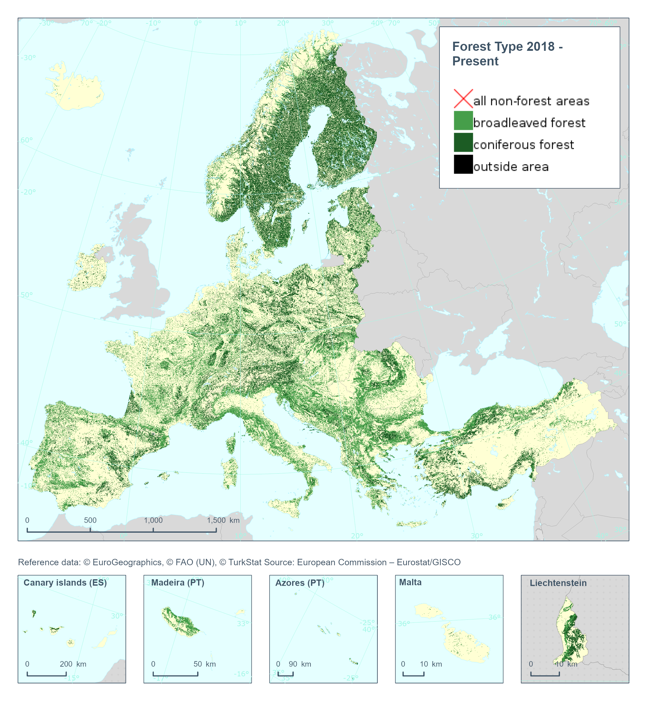
The High Resolution Layer Forest Type (FTY) provides a forest classification with 3 thematic classes (all non-forest areas / broadleaved forest / coniferous forest) at 10m spatial resolution and with a Minimum Mapping Unit (MMU) of 0.5 ha. This raster layer is largely following the FAO (Food and Agriculture Organisation of the United Nations) forest definition with tree covered areas in agricultural and urban context excluded using the respective Forest Additional Support Layer (FADSL). This dataset is provided on a 3-yearly frequency in 10 meter rasters (fully conformant with the EEA reference grid) in 100 x 100 km tiles covering the EEA38 countries. High Resolution Layer Tree Cover and Forest product is part of the European Union’s Copernicus Land Monitoring Service. This dataset includes data from the French Overseas Territories (DOMs)
-

This metadata refers to the CORINE Land Cover Plus Land Use, Land-Use Change and Forestry Instance (CLCplus LULUCF Instance), an annually updated, pan-European, spatially consistent and seamless geospatial proxy for land use reporting under the LULUCF regulation. The product is delivered as a single raster layer with a spatial resolution of 100 m, derived from multiple pan-European Copernicus Land Monitoring Service (CLMS) high resolution input datasets. The LULUCF Instance is available for the reference years 2018, 2021, 2022 and 2023, with production moving to an annual update cycle starting from the 2021 product. Each raster cell represents a dominant LULUCF land-use class, assigned according to thematic and spatial rulesets implemented during the extraction process. While each pixel corresponds primarily to one of the six main LULUCF land use categories - forest land, grassland, cropland, settlements, wetlands, and other lands - the dataset further differentiates these categories into sub classes, resulting in a total of 27 classes. This classification structure supports greenhouse gas reporting and other applications within the LULUCF sector by providing a harmonised and policy relevant representation of land use across Europe. It is crucial to understand that this product is fundamentally different from other CLMS products, as it is not based directly on satellite image classification or visual interpretation. Instead, it is produced through the combination and integration of existing CLMS data layers. Consequently, the dataset does not introduce fundamentally new information; rather, its novelty lies in the expert driven integration of multiple sources to produce a LULUCF oriented land use representation.
-
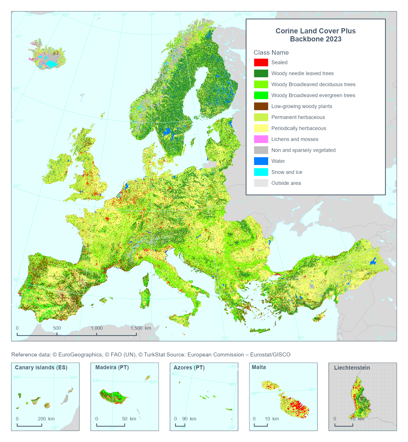
This metadata refers to the Corine Land Cover plus Backbone (CLCplus Backbone), a spatially detailed, large-scale, Earth Observation-based land cover inventory which is produced by the Copernicus Land Monitoring Service (CLMS). The CLCplus Backbone is a high-resolution raster land cover map based on Sentinel-2 satellite time series. Each 10m-pixel contains the dominant land cover among the 11 basic land cover classes. See pixel class codes in the 'Additional Information' section below. The product is available from the 2018 reference year, with a first update produced for the 2021 reference year and moved to an update cycle of 2 years from 2021 onwards.
-
The High Resolution Layer Forest Type (FTY) dataset provides the Forest Type estimation at 100 meter spatial resolution. The number of broadleaved and coniferous pixels are counted and the percentages stored in the 100m cell. The class 255 = outside area is predefined by the 100m boundary layer and remains unchanged. This dataset is provided on a 3-yearly frequency in 100 meter rasters (fully conformant with the EEA reference grid) in 100 x 100 km tiles covering the EEA38 countries. High Resolution Layer Tree Cover and Forest product is part of the European Union’s Copernicus Land Monitoring Service. This dataset includes data from the French Overseas Territories (DOMs)
-
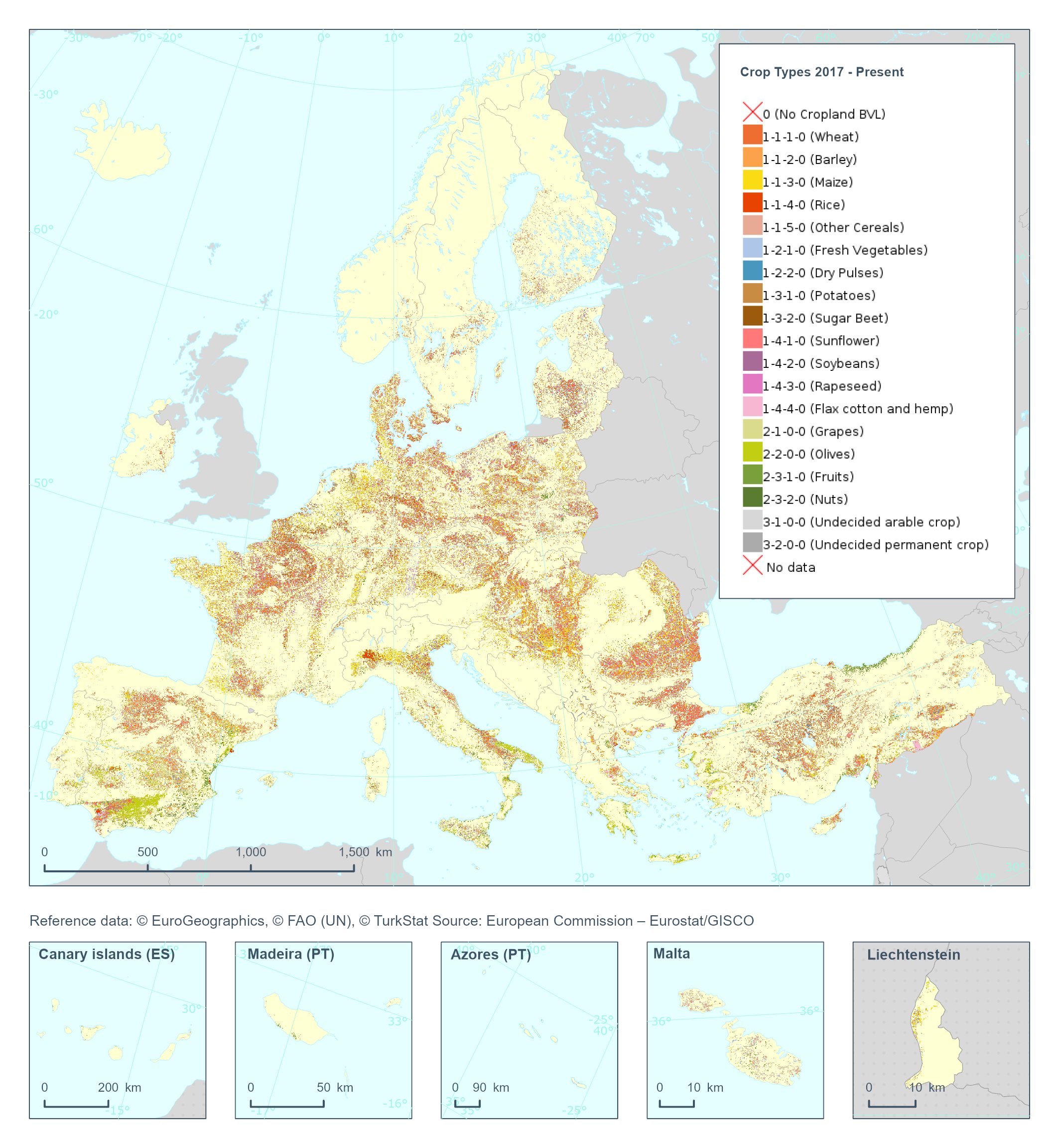
The High Resolution Layer Crop Types (CTY) raster product provides high resolution crop type classification for 17 classes of both arable and permanent crops accross the EEA38 extent. Using both Sentinel-1 and Sentiel-2, the model is finetuned to first map the crop field boundaries, and then determine the main crop for each field. This dataset is provided annually starting in 2017 with 10 meter rasters (fully conformant with the EEA reference grid) in 100 x 100 km tiles covering the EEA38 countries. High Resolution Layer Croplands product is part of the European Union’s Copernicus Land Monitoring Service. Confidence layer available for the dataset. This dataset includes data from the French Overseas Territories (DOMs)
-
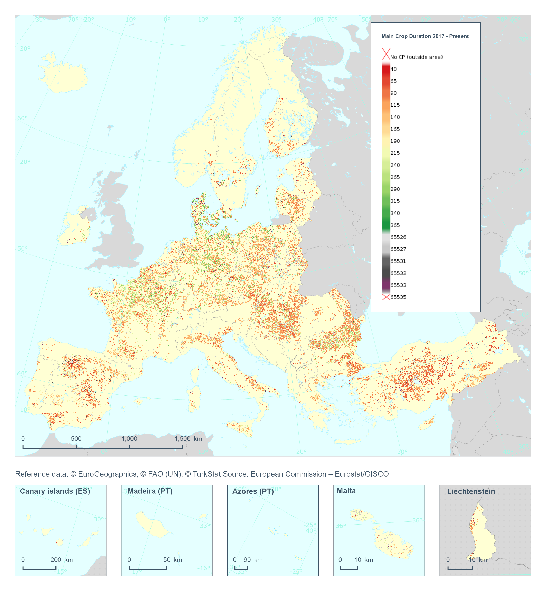
The High Resolution Layer Cropping Patterns - Main Crop Duration (CPMCD) raster product provides the duration (in days) of the growing season for the main (annual) crop. This dataset is provided annually starting in 2017 with 10 meter rasters (fully conformant with the EEA reference grid) in 100 x 100 km tiles covering the EEA38 countries. High Resolution Layer Croplands product is part of the European Union’s Copernicus Land Monitoring Service. Confidence layer available for the dataset. This dataset includes data from the French Overseas Territories (DOMs)