 Arctic SDI catalogue
Ciona intestinalis
Type of resources
Topics
Keywords
Contact for the resource
Provided by
Formats
Representation types
Update frequencies
status
-
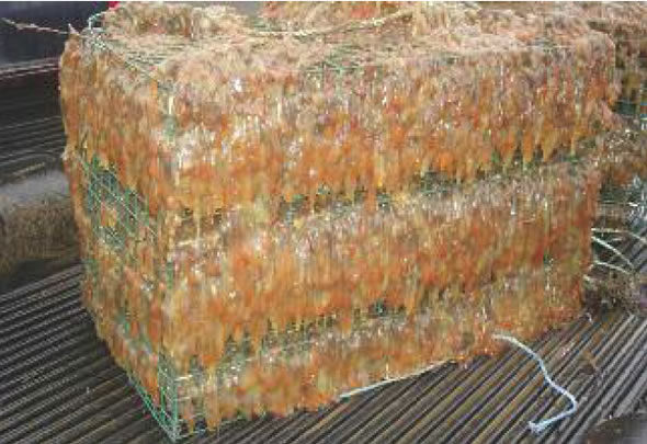
PURPOSE: Provide early detection of newly arrived Aquatic Invasive Species (AIS) and determine the spread, establishment and spatial distribution of existing AIS within marine waters of the southern Gulf of St. Lawrence (sGSL), DFO Gulf Region boundaries (northern and eastern coastal shores of NB, Gulf shore of NS, and PEI shoreline). DESCRIPTION: DFO Science monitors for AIS in the Gulf Region. The data collected from DFO's biofouling monitoring program provides an overview of the distribution and abundance of Aquatic Invasive Species (AIS) in the Gulf Region. This information can be used by the general public, scientists and DFO managers. Monitoring program targeting aquatic invasive species (AIS). Native biofouling species are not included in this dataset. Botrylloides violaceus: Violet tunicate Botryllus schlosseri: Golden star tunicate Ciona intestinalis: Vase tunicate Styela clava: Clubbed tunicate Caprella mutica*: Japanese skeleton shrimp Membranipora membranacea: Coffin box bryozoan Carcinus maenas*: European green crab Codium fragile*: Oyster thief alga Juxtacribrilina mutabilis**: Ribbed bryozoan (JCM) *indicates species that are not included as percent cover as they are not accurately captured by the sampling method, but are included as detections. **indicates species was only integrated fully into the monitoring protocol starting in 2025. Included here is a dataset of detection and percent cover data of AIS, as well as a monitoring station dataset. Environmental data collected, including from temperature loggers, are stored but not included here. PARAMETERS COLLECTED: Air and water temperature, salinity, depth, dissolved oxygen, weather conditions, list of biofouling AIS, percent cover of AIS on PVC plates, and incidental detection of other species and AIS in surrounding area. Only species data is pushed to the Open Data platform. NOTES ON QUALITY CONTROL: Each sample and species is processed and identified in a standardized fashion using standardized DFO Science AIS protocols and taxonomic references. Data is manually entered into DFO Gulf Region's AIS Science biofouling database and randomly verified for accuracy. SAMPLING METHODS: Biofouling monitoring is conducted using PVC collector plates that are deployed in the water column approximately 1 meter below the sea surface in the spring of each year. Biofouling organisms settle on these plates which are collected in the fall of the same year. Abundances of AIS are given as percent plate cover. Physico-chemical data including temperature, conductivity, and depth as well as weather conditions are noted at each geo-referenced biofouling monitoring site during initial deployment and at time of retrieval. All biofouling organisms settled on the underside of the PVC plates are noted and percent cover of each AIS is estimated. Any AIS present at the location is also noted. A HOBO temperature and light logger was deployed. USE LIMITATION: To ensure scientific integrity and appropriate use of the data, we would encourage you to contact the data custodian.
-

From August 5th to September 3rd, 2012, Fisheries and Oceans Canada conducted a baseline survey of marine fishes and their habitats on the Canadian Beaufort Shelf and slope. Sampling was conducted from the F/V Frosti at 28 stations along four transects. Standardized sampling was conducted at pre-determined depth stations (20-40, 75, 200, 350, 500, 750, and 1000 m) using a variety of sampling equipment including benthic fishing trawls, plankton nets, sediment cores, and CTD and water sample profiles. A specialized CTD probe (UCTD) was deployed at an additional 30 locations while the ship was underway. Presented here is the information on the sampling locations, and the sampling gear deployed at each station.
-

From August 2nd to September 9th, 2013, Fisheries and Oceans Canada conducted a baseline survey of marine fishes and their habitats on the Canadian Beaufort Shelf and slope. Sampling was conducted from the F/V Frosti at 64 stations along ten transects. Standardized sampling was conducted on the transects at pre-determined depth stations (20-40, 75, 200, 350, 500, 750, and 1000 m) using a variety of sampling equipment including benthic fishing trawls, plankton nets, sediment cores, and CTD and water sample profiles. A specialized CTD probe (UCTD) was deployed at an additional 72 locations while the ship was underway.Presented here is the information on the sampling locations, and the sampling gear deployed at each station.
-
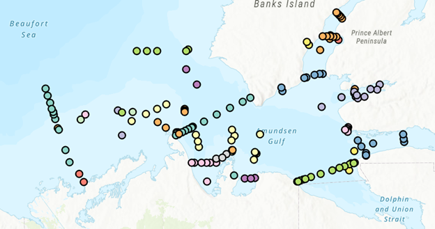
PURPOSE: The Department of Fisheries and Oceans (DFO) conducted a baseline survey of biological communities and habitat parameters in the offshore Canadian Beaufort Sea between 2012 and 2014, as part of the federally administered Beaufort Regional Environmental Assessment. The BREA-Marine Fishes Project (BREA-MFP) was the first comprehensive baseline study of offshore marine fish diversity and associated habitats in the Canadian Beaufort Sea. Knowledge gained during the BREA-MFP supports regulatory processes pertaining to offshore development and Oceans Management in the Inuvialuit Settlement Region, and provides baseline context for studies of the effects of climate change and variability. The Canadian Beaufort Sea – Marine Ecosystem Assessment (CBS-MEA, 2017-2019 and 2021-2024) is building on system baselines and ecological knowledge derived from the BREA-MFP to develop a comprehensive research and monitoring approach for the offshore Canadian Beaufort Sea. This approach will enable us to better understand the relationship between oceanographic drivers and ecosystem responses. The CBS-MEA focuses on integrating oceanography, food web linkages, physical-biological couplings and spatial and inter-annual variabilities, while also expanding baseline coverage of species diversity, abundances, and habitat associations to areas of the Beaufort Sea and Canadian Archipelago that are previously unstudied in this context. DESCRIPTION: Between 2017 and 2019, and between 2021 and 2024, Fisheries and Oceans Canada conducted a baseline survey of marine fishes and their habitats on the Canadian Beaufort Shelf and slope in August and early September each year. Sampling was conducted from the F/V Frosti at over 150 stations along ten multi-year transects, and over 50 non-transect stations. Standardized sampling was conducted at pre-determined depth stations (20-40, 75, 200, 350, 500, 750, and 1000 m) using a variety of sampling equipment including benthic fishing trawls, plankton nets, sediment cores, and CTD and water sample profiles. Presented here is the information on the sampling locations, and the sampling gear deployed at each station.
-

From August 6th to September 9th, 2014, Fisheries and Oceans Canada conducted a baseline survey of marine fishes and their habitats on the Canadian Beaufort Shelf and slope. Sampling was conducted from the F/V Frosti at 56 stations along thirteen transects, with an additional three stations not located on transects. Standardized sampling was conducted on the transects at pre-determined depth stations (20-40, 75, 200, 350, 500, 750, and 1000 m) using a variety of sampling equipment including benthic fishing trawls, plankton nets, sediment cores, and CTD and water sample profiles. Presented here is the information on the sampling locations, and the sampling gear deployed at each station.