 Arctic SDI catalogue
Clupea harengus
Type of resources
Topics
Keywords
Contact for the resource
Provided by
Formats
Representation types
Update frequencies
status
-
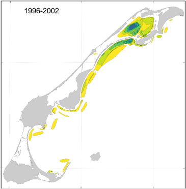
This cartographic dataset of areas of importance for spring herring in the Magdalen Islands was produced by Fisheries and Oceans Canada (DFO) and the Magdalen Islands ZIP Committee, as part of the work to characterize the Magdalen Islands Lagoons Marine Refuge. The initiative aimed to document fishermen's ecological knowledge of spring herring, including good fishing areas and spawning grounds around the archipelago. The data comes from interviews conducted between January and April 2024 with the most experienced fishermen in the archipelago. During the interviews, participants identified directly on digital maps the locations associated with four types of observations made throughout their careers: • Question 8 — Good fishing sites; • Question 9 — Other observations of high concentrations of the resource; • Question 13a — Spawning areas and; • Question 13b — Other observations of signs of spawning. To facilitate temporal contextualization, a four-period timeline (before 1996, 1996-2002, 2003-2006, and 2007-2021) was used. The final product is a GeoPackage (.gpkg) containing 16 vector layers composed of four layers per observation type, each corresponding to one of the defined time periods. The polygons were classified according to the number of fishermen who reported each location, making it possible to assess the degree of overlap and the relative importance of the areas over time. The data are projected in NAD83 / MTM zone 4. For more information on the methodology and data, see Burbank et al. (2025). Additional information specific to the Magdalen Islands lagoons is presented in Grégoire et al. (2026).
-

PURPOSE: The research survey provides a fisheries-independent source of information about all marine living organisms that are captured by the fishing trawl used to obtain samples in the southern Gulf of St. Lawrence. DESCRIPTION: Tow, catch, length frequency, and biological information for fish caught during the annual September research vessel trawl surveys in the southern Gulf of St. Lawrence (NAFO Division 4T). Abundance indices and spatial distribution patterns of commercial and non-commercial groundfish. The catch data that appear in this dataset SHOULD NOT BE USED FOR ECOLOGICAL ANALYSES INVOLVING CATCH RATES. Important factors such as vessel, fishing gear and diurnal periods must be accounted for to use these data in analyses. Please contact the data custodians if you are interested in using this data for any kind of ecological analyses involving catch rates. PARAMETERS COLLECTED: Abundance estimates (ecological); distribution (ecological); species counts (ecological); gear (fishing); vessel information (fishing); point (spatial) NOTES ON QUALITY CONTROL: Scientific names listed in the survey species list have been mapped to recognized standards - marine taxa have been mapped to the World Register of Marine Species (WoRMS) using their online taxon match tool. All sampling locations were plotted on a map to perform a visual check confirming that the latitude and longitude coordinates were within the described sampling area. In 2003, because of a fire aboard the Alfred Needler, the Wilfred Templeman was used for the survey. However, no comparative fishing experiments have been conducted between the Alfred Needler and the Wilfred Templeman. We are therefore unable to integrate the indices derived for 2003 to the remainder of the survey time-series. SAMPLING METHODS: Sampling Method: Consult the "Protocols for research vessel cruises within the Gulf Region (dermersal fish) (1970-1980)" report, link provided in the citations list. USE LIMITATION: To ensure scientific integrity and appropriate use of the data, we would encourage you to contact the data custodian.