 Arctic SDI catalogue
Données ouvertes
Type of resources
Available actions
Topics
Keywords
Contact for the resource
Provided by
Formats
Representation types
Update frequencies
status
Resolution
-
Polyline feature layer of winter trails in Manitoba provincial parks. This feature layer contains polylines showing locations of winter trails in Manitoba provincial parks. Winter trails are those trails designated for certain winter activities, such as cross-country skiing, skijoring, skate-skiing, fat biking, and dog sledding. Most of these trails are groomed by Manitoba Parks staff throughout the season. This layer is used in the interactive map Manitoba Parks - Winter Activity Trails Map and the web app Manitoba Parks - Winter Trails and Recreation Areas. The dataset includes the following fields (Alias (Name): Description) Trail Name (Trail_Name): Name of the trail Park Name (Park_Name): Name of the provincial park where the trail is located Winter Use (Winter_Use): Indicates whether or not the trail is designated for winter use (Note: All features in this layer have a value of 'Yes') For more information about winter activities, visit the Manitoba Parks website.
-
Source data for an on-line interactive map of Manitoba showing the locations of recycling depots. The Sustainable and Green Initiatives branch collect location and information data (name of the facility, address, hours of operation and phone number) from 12 producer responsibility organizations (PRO) on an annual basis.This is a point layer symbolized by the items accepted at that location.Fields Included: loc_ID Location identification number name Name of depot phone Phone number (if available) hours Hours and other details (if available) location_name Generic name of location (if available) box_unit P.O. Box number of Unit number (if available) address Street number and Street name City nearest City Province Province Postal Code Postal Code Country Country Latitude Latitude in Decimal Degrees Longitude Longitude in Decimal Degrees is_active Indicates if the location is actively accepting items website Website URL address (if available) created_date Date entry was created modified_date Date entry was modified by the branch cell_phones Indicates if this item is accepted, if blank it is not accepted at this location paint Indicates if this item is accepted, if blank it is not accepted at this location tires Indicates if this item is accepted, if blank it is not accepted at this location electronics Indicates if this item is accepted, if blank it is not accepted at this location plastic_bags Indicates if this item is accepted, if blank it is not accepted at this location oil_and_antifreeze Indicates if this item is accepted, if blank it is not accepted at this location Pharmaceuticals Indicates if this item is accepted, if blank it is not accepted at this location Rechargable_Batteries Indicates if this item is accepted, if blank it is not accepted at this location Fluorescent_Lights Indicates if this item is accepted, if blank it is not accepted at this location Mercury_containing_thermometers Indicates if this item is accepted, if blank it is not accepted at this location Blue_box_materials Indicates if this item is accepted, if blank it is not accepted at this location Lead_acid_batteries Indicates if this item is accepted, if blank it is not accepted at this location Pesticide_containers Indicates if this item is accepted, if blank it is not accepted at this location Scrap_metal Indicates if this item is accepted, if blank it is not accepted at this location textiles Indicates if this item is accepted, if blank it is not accepted at this location mattresses Indicates if this item is accepted, if blank it is not accepted at this location refrigeration_cooling Indicates if this item is accepted, if blank it is not accepted at this location
-
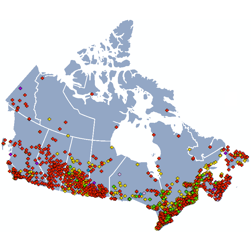
The Open Database of Healthcare Facilities (ODHF) is a collection of open data containing the names, types, and locations of health facilities across Canada. It is released under the Open Government License - Canada. The ODHF compiles open, publicly available, and directly-provided data on health facilities across Canada. Data sources include regional health authorities, provincial, territorial and municipal governments, and public health and professional healthcare bodies. This database aims to provide enhanced access to a harmonized listing of health facilities across Canada by making them available as open data. This database is a component of the Linkable Open Data Environment (LODE).
-
The intention is to show the boundaries of all refuges in Manitoba, as designated by the Designation of Wildlife Lands Regulation (171/2001) under The Wildlife Act (C.C.S.M. c. W130). Refuge types include Wildlife Refuge, Game Bird Refuge, Goose Refuge, and Fur Bearing Animal Refuge. The Use of Wildlife Lands Regulation (77/99) determines what activities are prohibited within each refuge. Boundaries are drawn based on the physical description described in regulation, or imported using CAD files from the official Director of Surveys Plan stated in regulation.
-
Forest Management in Canada Web App: 2017 and 2020 (French)
-
Canadas Managed Forests 2020 Vector Tile Layer
-
This feature class represents Manitoba's Forest Management Unit (FMU) boundaries. Forest Management Units (FMU's) define a forested area with common forest conditions that are managed in a similar manner. Forest Sections are comprised of FMU's. Forest inventories within Forest Management Units are analysed to determine allowable harvest limits of softwood and hardwood tree species within each Forest Management Unit. Version 3: The southern portion of FMU 67 within the Highrock Forest Section has been adjusted to align with base features captured in 2009. Additionally, an 11 hectare portion of the Saskatchewan River Forest Section (FMU 59) has been added to the Highrock Forest Section. Version 4: The northern portion of FMU 68 along the Rail Haul within the Highrock Forest Section has been adjust so that the boundary falls within water only. Additionally, version 4 splits the 'White Zone' forest section (FMU 76) by ecozones, creating FMU 76 (Taiga Shield), FMU 77 (Southern Arctic), FMU 78 (Hudson Plain) and FMU 79 (Boreal Shield). Version 4 is dated February 8, 2013. Fields Included: OBJECTID: Sequential unique whole numbers that are automatically generated . MANAGEMENT_UNIT_NUMBER : Management Unit (MU) number . S ECTION : Forest section number . SECTION_NAME : Forest section name .
-

This dataset supports the assessment of plankton community structure and water quality within Toronto Area of Concern (AOC). The data was collected to evaluate the Beneficial Use Impairment (BUI) 13 - Degradation of Phytoplankton and Zooplankton Populations, and to provide georeferenced habitat information relevant to BUI 14 - Loss of Fish and Wildlife Habitat. The dataset provides a complete suite of water quality, microbial, phytoplankton and zooplankton observations collected from multiple georeferenced stations throughout the Toronto Harbor. Each datapoint includes latitude and longitude, sampling date, year and season, along with physiochemical measurements such as temperature, dissolved oxygen, total phosphorus, total nitrogen, nitrate + nitrite, chlorophyll-a and turbidity. Biological data includes phytoplankton, zooplankton and rotifer abundance and biomass across major taxonomic groups, as well as size structured zooplankton data distinguishing small and large taxa. The dataset also includes microbial community metrics and rate-based parameters such as bacterial growth rates, primary productivity and bacterial production. Sampling was conducted across multiple ecotypes identified by “Area” in the dataset (Inner Harbor, Islands, Habitat Cells and Embayments). The data structure allows for comparisons among sites, seasons, ecotypes and provides the basis for statistical analysis of plankton community composition, trophic relationships and ecological patterns within the AOC of Toronto Harbor. Results indicate water quality, zooplankton abundance and biomass differed across habitat ecotypes, with Inner Harbor exhibiting very low biomass similar to the open waters of Lake Ontario and a higher proportion of small taxa like rotifers, in spite of elevated nutrients. This pattern suggests environmental stress from runoff and contamination from the surrounding urban area. Zooplankton prey reductions are likely due to multiple urban environmental impacts including runoff and contaminants. Ecotype impacted zooplankton productivity but not primary productivity, indicating that protected systems (Island channels, Habitat Cells and Embayments) can offer diverse physical habitats and forage for fishes. Though primary productivity rates were reduced in most habitats, productivity was shunted into bacterial growth which were highly elevated throughout the entire AOC.
-
RHA Districts are geographic areas that are used to define populations and catchment areas for the administration and delivery of health services. This file provides RHA district boundaries for cartographic and analytical purposes. Within Manitoba there are five Regional Health Authorities (or "RHAs") responsible for the delivery of health service in five specific areas of the province described as "health regions". (In practice, the terms "health region" and "RHA" are used interchangeably to describe these geographic areas.) In consultation with Manitoba Health, Healthy Living and Seniors, and with the Manitoba Centre for Health Policy, each of the RHAs has defined further subdivisions within each RHA . These sub-areas of each RHA generally correspond to areas of clustered population and/or service delivery. They are used to plan service delivery, and are also used to describe and analyze population health and health service use with more specificity than analysis at the RHA level could provide. Due to the size and the total population of Manitoba's RHAs, there are two levels of subdivided RHA geography which are used for analytical and planning purposes. The smallest subdivisions used for this purpose are RHA Districts. RHA Districts within an RHA are also grouped into larger sub-areas with the RHA called RHA Zones, within each RHA District within an RHA included in precisely one of these zone. This shapefile contains the boundaries of Manitoba's RHA districts.
-
The purpose of this dataset is to show end users where LiDAR data has been acquired by the Government of Manitoba. LiDAR (Light Detection and Ranging) is a remote sensing technology that uses lasers to collect accurate, continuous elevation data over relatively large areas. These data are essential for activities such as forestry, flood risk management, land use planning, and natural resources management. The Manitoba Government is increasingly acquiring LiDAR data across the province.This layer was created on August 5, 2009 by Manitoba Sustainable Development and was updated on August 9, 2021.To download LiDAR data from the Manitoba Land Initiative (MLI) site, follow this link: https://mli2.gov.mb.ca/dems/index_external_lidar.html Fields included ( Alias (Field Name): Field description.) ObjectID (OBJECTID) - Automatically generated feature numberAcquired (ACQUIRED) - LiDAR data capture dateContractor (CONTRACTOR) - Contractor nameContributor (CONTRIB) - Manitoba Government departmentName (NAME) - Dataset nameCellsize (CELLSIZE) - Raster DEM cell sizeMLI (MLI) - Data available for download on the Manitoba Land Initiative site