 Arctic SDI catalogue
Marine refuge
Type of resources
Topics
Keywords
Contact for the resource
Provided by
Formats
Representation types
Update frequencies
status
-
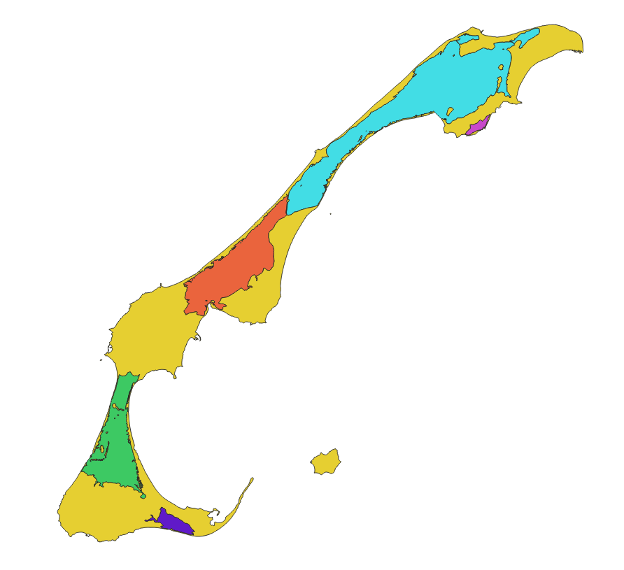
This cartographic dataset represents a geomorphological update of the boundaries of the five inland water bodies that form the Magdalen Islands Marine Refuge. It was produced by Fisheries and Oceans Canada (DFO) as part of its marine refuge characterization work. The data used comes from the August 15, 2022 version of the Quebec maritime Geospatial Database of Coastal Ecosystems (GDB), developed from various sources including satellite and airborne images from 2019 (Jobin et al. 2021; Provencher-Nolet et al. 2024). The boundaries of the inland water bodies were defined according to the upper high tide line, which represents the maximum extent of the water during the highest tides. The final product is a polygonal shapefile representing the five inland water bodies of the marine refuge as well as the terrestrial areas of the archipelago. The data are projected in NAD83 / MTM zone 4. For more information on the method used to generate this layer from the GDB, see Grégoire et al. (2026). The method used to create the source geospatial data is described in Jobin et al. (2021) and Provencher-Nolet et al. (2024).
-
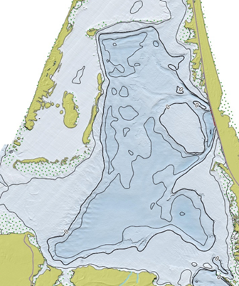
This bathymetric dataset of the five inland water bodies of the Magdalen Islands was produced by the Quebec Regional Science Directorate (DRS) of Fisheries and Oceans Canada (DFO) as part of the characterization of the Magdalen Islands lagoon marine refuge. The data comes from several sources, including a bathymetric LiDAR survey, satellite-derived bathymetry (SDB), acoustic surveys, and spot depth sampling conducted in inland water bodies. The final product is a 5 m resolution raster projected in NAD83 / MTM zone 4. Depths are expressed in meters and reduced to chart datum (CD). This dataset is provided for information, analysis, and research purposes and is not intended for navigation. This dataset is a derived scientific product generated through processing, interpolation, and integration conducted by a DRS research team, and it does not constitute a hydrographic product of the Canadian Hydrographic Service (CHS). The data may contain uncertainties, acquisition artifacts, or processing errors, and do not meet the hydrographic standards of the International Hydrographic Organization (IHO). This dataset is provided exclusively for informational, analytical, management, and scientific research purposes. It must not be used for navigation, for operational decision‑making at sea, or for any activity where the safety of persons or property may depend on the accuracy of depth information. DFO and CHS disclaim all liability for the use, interpretation, or decisions made on the basis of this product. For more information on the methodology and an overview of the results, see the report by Grégoire et al. (2026).