 Arctic SDI catalogue
Boundaries
Type of resources
Available actions
Topics
Keywords
Contact for the resource
Provided by
Years
Formats
Representation types
Update frequencies
status
Service types
Scale
-

'Province' and 'territory' refer to the major political units of Canada. From a statistical point of view, province and territory are basic areas for which data are tabulated. Canada is divided into 10 provinces and 3 territories. Statistics Canada uses standard codes and abbreviations to represent provinces and territories. The two-digit code that uniquely identifies each province/territory is based on the Standard Geographical Classification (SGC). The code is assigned from east to west. The first digit represents the geographical region of Canada in which the province/territory is located and the second digit denotes one of the 10 provinces and 3 territories.
-
Standardized metadata template, for identifying knowledge locations on Arctic Coastal Ecosystems applicable for different knowledge systems. This template was developed by the Nordic Coastal Group, composed of the Nordic representatives on CBMP Coastal. The template is intended to identify locations for Indigenous Knowledge, Scientific, Hunters Knowledge, Local Knowledge, and community-based monitoring. The template is composed of two files a Word document that provides the rationale and detailed description for the Excel sheet that allows for standardized data gathering
-

In 2021, the Canada Coast Guard (CCG) and Fisheries and Oceans Canada updated its administrative boundaries following the creation a new Arctic region. There are now 4 administrative regions in CCG (Western, Arctic, Central and Atlantic). DFO and Coast Guard Arctic Regions developed these regions in partnership with the people they serve; this important decision will lead to stronger programs and services to better meet the unique needs of our Arctic communities. DFO and CCG operations and research cover Canada's land and waters to the international boundaries (EEZ) and are in no way limited to the boundaries drawn in the map.
-
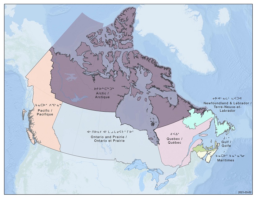
In 2021, the Canada Coast Guard (CCG) and Fisheries and Oceans Canada (DFO) updated its administrative boundaries following the creation a new Arctic region.There are now 7 administrative regions in DFO (Pacific, Arctic, Ontario and Prairie, Quebec, Gulf, Maritimes, Newfoundland and Labrador). DFO and Coast Guard Arctic Regions developed these regions in partnership with the people they serve; this important decision will lead to stronger programs and services to better meet the unique needs of our Arctic communities.DFO and CCG operations and research cover Canada's land and waters to the international boundaries (EEZ) and are in no way limited to the boundaries drawn in the map.
-

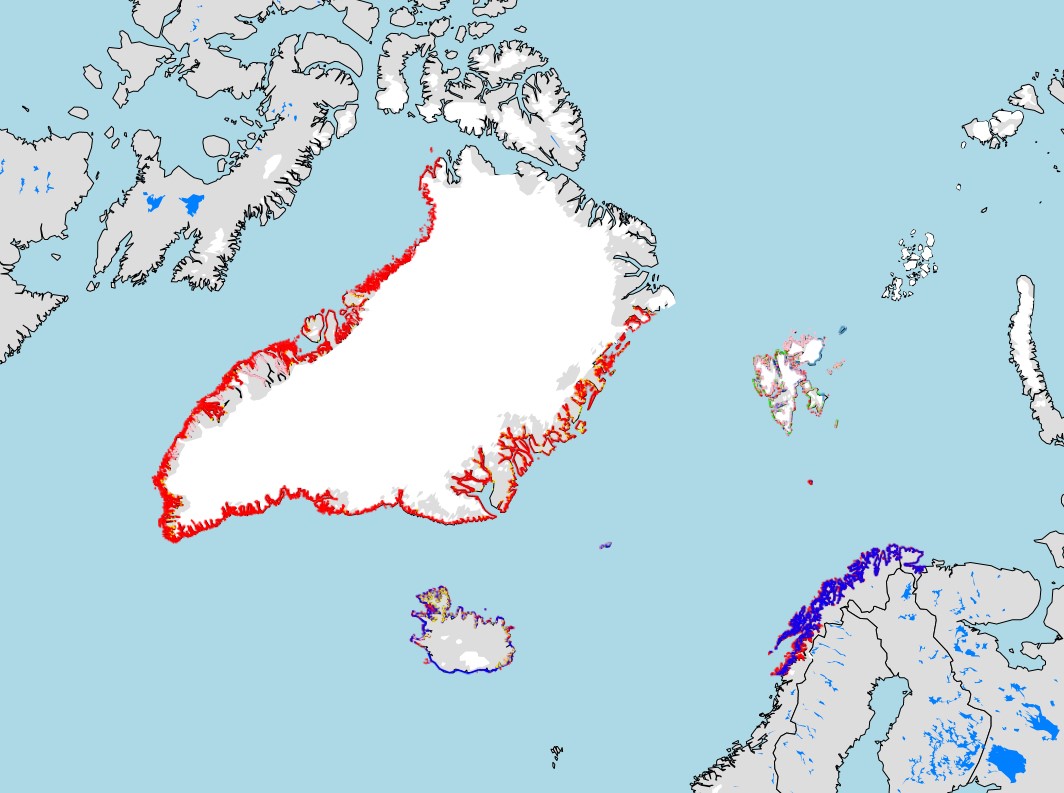
Canadian Hydrographic Service (CHS) has made available all the publishable limits of modern day surveys whose data has been collected since 1989.
-
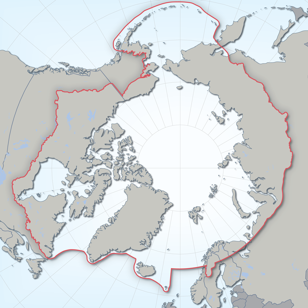
Defines the area covered by the the Conservation of Arctic Flora and Fauna (CAFF) working group of the Arctic Council. Each Arctic Council country was responsible for defining their Arctic boundary.
-

The 2023 Road Network File depicts the digital road line coverage for Canada. It contains information such as street arc unique identifier (UID), name, type, direction and address range, as well as class. It also includes province or territory (PR) and census subdivision (CSD) information for each side of a street arc (where applicable).The Road Network File is portrayed in Lambert conformal conic projection (North American Datum of 1983 [NAD83]). The 2023 Road Network File is available as a national file.
-

The spatial representation for the boundary of an Agricultural Land Reserve (ALR), which is a parcel of land, based on soil and climate, deemed necessary to be maintained for agricultural use. The data gets updated four times a year, at the end of: Jan, Apr, Jul and Oct. It is also available on the ALC's website: https://www.alc.gov.bc.ca/alr-maps/ History: ALR hard copy base (1:50000) and large scale constituent maps. Compilation from hard copy maps rectified to standard provincial base digital data (TRIM, CDMS, ICI, PMBC). Resolution: Variable, determined for feature from base source. Registry: Land Reserve Commission, 201-4940 Canada Way, Burnaby BC, V5G-4K6, (604)660-7000
-
The spatial representation for a segment of the boundary of an Agricultural Land Reserve (ALR), which is a parcel of land, based on soil and climate, deemed necessary to be maintained for agricultural use. The ALR digital data is not considered the official representation of the ALR. History: ALR hard copy base (1:50000) and large scale constituent maps. Compilation from hard copy maps rectified to standard provincial base digital data (PMBC, TRIM, CDMS, ICI). Resolution: Variable, determined for feature from base source. Registry: Land Reserve Commission, 133-4940 Canada Way, Burnaby BC, V5G-4K6, (604)660-7000
-
Displays the geographical extent of products produced by the Canadian Hydrographic Service, including: individual paper charts, vector Electronic Navigational Charts (ENC), and digital raster charts collections (BSB).