 Arctic SDI catalogue
Photovoltaic
Type of resources
Topics
Keywords
Contact for the resource
Provided by
Formats
Representation types
Update frequencies
status
-
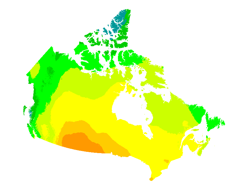
This web mapping application gives estimates of the electricity that can be generated by grid-connected photovoltaic systems without batteries (in kWh/kWp) and of the mean daily global insolation (in MJ/m2 and in kWh/m2) for any location in Canada on a 60 arc seconds ~2 km grid. They are presented for each month and for the entire year, for six different PV array orientations: a sun-tracking orientation and five fixed South-facing orientations with latitude, vertical (90°), horizontal (0°) and latitude ± 15° tilts. Data can also be obtained directly for individual municipalities from a list of over 3500 municipalities or downloaded for all municipalities at once. These maps and datasets were developed by the Canadian Forest Service (Great Lakes Forestry Centre) in collaboration with the CanmetENERGY Photovoltaic systems group and the Federal Geospatial Platform. Insolation data were provided by Environment and Climate Change Canada. Web map application developed by Federal Geospatial Platform, 2020. References: Pelland S., McKenney D. W., Poissant Y., Morris R., Lawrence K., Campbell K. and Papadopol P., 2006. The Development of Photovoltaic Resource Maps for Canada, In Proceedings of the Annual Conference of the Solar Energy Society of Canada (SESCI) 2006. McKenney D. W., Pelland S., Poissant Y., Morris R., Hutchinson M, Papadopol P., Lawrence K. and Campbell K., 2008. Spatial insolation models for photovoltaic energy in Canada, Solar Energy 82, pp. 1049–1061.