 Arctic SDI catalogue
Radiation
Type of resources
Topics
Keywords
Contact for the resource
Provided by
Formats
Representation types
Update frequencies
status
-
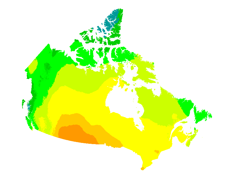
This web mapping application gives estimates of the electricity that can be generated by grid-connected photovoltaic systems without batteries (in kWh/kWp) and of the mean daily global insolation (in MJ/m2 and in kWh/m2) for any location in Canada on a 60 arc seconds ~2 km grid. They are presented for each month and for the entire year, for six different PV array orientations: a sun-tracking orientation and five fixed South-facing orientations with latitude, vertical (90°), horizontal (0°) and latitude ± 15° tilts. Data can also be obtained directly for individual municipalities from a list of over 3500 municipalities or downloaded for all municipalities at once. These maps and datasets were developed by the Canadian Forest Service (Great Lakes Forestry Centre) in collaboration with the CanmetENERGY Photovoltaic systems group and the Federal Geospatial Platform. Insolation data were provided by Environment and Climate Change Canada. Web map application developed by Federal Geospatial Platform, 2020. References: Pelland S., McKenney D. W., Poissant Y., Morris R., Lawrence K., Campbell K. and Papadopol P., 2006. The Development of Photovoltaic Resource Maps for Canada, In Proceedings of the Annual Conference of the Solar Energy Society of Canada (SESCI) 2006. McKenney D. W., Pelland S., Poissant Y., Morris R., Hutchinson M, Papadopol P., Lawrence K. and Campbell K., 2008. Spatial insolation models for photovoltaic energy in Canada, Solar Energy 82, pp. 1049–1061.
-

The MODIS surface albedo dataset was produced by the Canada Center for Remote Sensing (CCRS), Natural Resources Canada. The dataset represents the solar shortwave broadband surface albedo and it is at a 10-day interval covering the entire Canadian landmass as well as northern USA, Alaska, and the Greenland. The dataset was derived from the Moderate Resolution Imaging Spectroradiometer (MODIS) onboard the TERRA satellite which provides a global coverage every 1-2 days in 36 spectral bands ranging from visible to infrared and to thermal wavelengths between 405 and 14,385 nm, and was available since 2000. For the estimation of surface albedo, the first seven spectral bands of B1 to B7 ranging from 459 nm to 2155 nm were used. B1 and B2 have a 250 meter resolution and B3 to B7 have a 500 meter resolution. A downscaling method using a regression and normalization scheme was employed to downscale the bands B3 to B7 to 250 meter resolution while preserving radiometric properties of the original data. To obtain clear-sky observations from MODIS, composite images for a 10 day period were generated by using a series of advanced algorithms (Luo et al., 2008). The 10-day composites of B1-B7 reflectance were then used to retrieve spatially continuous spectral albedo by using a combined land/snow BRDF (Bi-directional Reflectance Distribution Function) model. In that method, the modified RossThick-LiSparse BRDF model (Maignan et al., 2004) for land and Kokhanovsky and Zege’s model (2004) for snow are linearly combined for mixed surface conditions. They are weighted by snow fraction (0.0 ~ 1.0). The seven spectral albedo were then converted into the shortwave broadband surface albedo using the empirical MODIS polynomial conversion equation of Liang et al. (1999). The data product is in LCC (Lambert Conformal Conic) projection with a 250m pixel resolution. There are 36 albedo images per year. A dataset representing the pixel state (e.g. cloud/shadow, snow/ice, water, land, et al.) was also generated for each 10-day corresponding to the surface albedo product. References: Kokhanovsky, A. A. and Zege, E. P., 2004, Scattering Optics of Snow, Applied Optics, 43, 1589-1602, doi:10.1364/AO.43.001589, 20. Liang, S., Strahler, A.H., Walthall, C., 1999. Retrieval of land surface albedo from satellite observations: a simulation study. J. Appl. Meteorol. 38, 712–725. Luo, Y., Trishchenko, A.P., Khlopenkov, K.V., 2008. Developing clear-sky, cloud and cloud shadow mask for producing clear-sky composites at 250-meter spatial resolution for the seven MODIS land bands over Canada and North America. Remote Sens. Environ. 112, 4167–4185. Maignan, F., F.M. Bréon and R. Lacaze, 2004, Bidirectional reflectance of Earth targets : evaluation of analytical models using a large set of spaceborne measurements with emphasis with the hot spot, Remote Sens. Environ., 90, 210-220.