 Arctic SDI catalogue
jpeg
Type of resources
Available actions
Keywords
Contact for the resource
Provided by
Years
Formats
Update frequencies
status
Service types
-

This service includes topographical maps on a scale of 1:1 to 1:300,000.
-

This service includes topographical maps on a scale of 1:1 million.
-

Tjenesten inneholder FKB data i større målestokk en 1:12000 i gråtone.
-

Tjenesten inneholder FKB data i større målestokk en 1:12000
-

Traktorveger fra FKB data og Skogsbilveger fra Vegnett data. Tjenesten har blitt gjort for bruk i en NIBIO web klient.
-

Fastmerkene er markert i terrenget med metallbolter som vanligvis er satt ned i fast fjell. Fastmerkene er inndelt i stamnettpunkter, landsnettpunkter, trekantpunkter og nivellementsfastmerker. Basestasjonene er permanente GNSS-stasjoner som samler GNSS-data hele tiden. Stasjonene danner grunnlaget for posisjonstjenesten CPOS. Data fra de permanente stasjonene brukes også til geodetiske beregninger.
-

WMS-tjenesten viser innholdet i SSR og er symbolisert for å vise ulike faglige tilnærminger. Sentralt stadnamnregister (SSR) er Noregs offisielle register over stadnamn i offentleg bruk. Med heimel i § 12 i lov om stadnamn har Kartverket fått oppgåva å drifte og utvikle dette registeret.
-

Tjenesten viser enkelt eiendomskart basert på daglig uttrekk fra Matrikkelen (Geonorge distribusjonsløsning). Skiller ikke mellom ulike matrikkelenhetstyper. Viser ikke anleggsprojeksjonsflater (anleggseiendom, volumer over/under bakken). Skiller ikke på god eller dårlig stedfestingsnøyaktighet. Viser hjelpelinjer stiplet. Inneholder også adressepunkt.
-
.png)
The WMS MSSP-EEZ (INSPIRE) represents marine seismic survey profiles for the German EEZ. During the period from 1996 to 2007 five cruises operated by BGR acquired seismic lines from the German EEZ. The aim of these cruises was a detailed survey of the geological structure of the seabed from the North Sea and Baltic Sea. According to the Data Specification on Geology (D2.8.II.4_v3.0, subtopic Geophysics) the content of the information with respect to the seismic profiles is INSPIRE-compliant. The WMS MSSP-EEZ (INSPIRE) contains for each cruise one layer, e.g. GE.seismicLine.pq2. The expeditions are displayed correspondingly to the INSPIRE portrayal rules. Via the getFeatureInfo request the user obtains the content of the INSPIRE attributes platformType und profileType. Additionally, the WMS contains a campaign layer (GE.2DSeismicSurvey) with the INSPIRE attributes campaignType and surveyType.
-
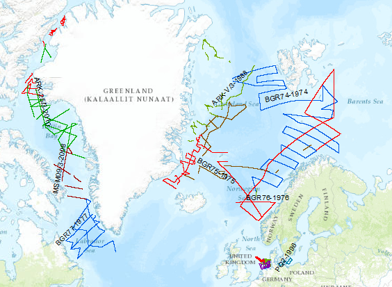
During the period from 1974 to 2010 various cruises from BGR acquired seismic lines worldwide. The aim of these marine expeditions was a detailed survey of the geological structure.