 Arctic SDI catalogue
Benthic Habitat
Type of resources
Topics
Keywords
Contact for the resource
Provided by
Formats
Representation types
Update frequencies
status
-

The data layer (.tif) presented are the results of using MaxEnt to produce a single species habitat map for Sea Scallop (Placopecten magellanicus) on German Bank (off South West Nova Scotia, Canada). Presence data derived from videos and still images were compared against environmental variables derived from multibeam bathymetry (Slope, Curvature, Aspect and Bathymetric Position Index (BPI)), and backscatter data (principal components: Q1, Q2, and Q3). Results represent a probability of habitat suitability for Sea Scallop on German Bank. Probability of suitability: The probability that a given habitat is suitable for a species based on presence data and underlying environmental variables (i.e. probability of species occurrence). Reference: Brown, C. J., Sameoto, J. A., & Smith, S. J. (2012). Multiple methods, maps, and management applications: Purpose made seafloor maps in support of ocean management. Journal of Sea Research, 72, 1–13. https://doi.org/10.1016/j.seares.2012.04.009 Cite this data as: Brown, C. J., Sameoto, J. A., & Smith, S. J. Data of: Distribution of Sea Scallop on German Bank. Published: February 2021. Population Ecology Division, Fisheries and Oceans Canada, Dartmouth, N.S. https://open.canada.ca/data/en/dataset/2bb98a09-5daf-42c4-94e8-e5de718b821d
-

The data layer (.shp) presented is the result of an unsupervised classification method for classifying seafloor habitat on German Bank (off South West Nova Scotia, Canada). This method involves separating environmental variables derived from multibeam bathymetry (Slope, Curvature) and backscatter (principal components: Q1, Q2, and Q3) into spatial units (i.e. pixels) and classifying the acoustically separated units into 5 habitat classes (Reef, Glacial Till, Silt, Silt with Bedforms, and Sand with Bedforms) using in situ data (imagery). Benthoscape classes (synonymous to landscape classifications in terrestrial ecology) describe the geomorphology and biology of the seafloor and are derived from elements of the seafloor that were acoustically distinguishable. Unsupervised classifications (acoustic classifications) optimized at 15 classes using Idrisi CLUSTER method (pixel based) Number representing the benthoscape classes (CLASS) derived from in situ imagery and video (See Brown et al., 2012, Figure 3, Table 1). Benthoscape classes (See Brown et al., 2012, Figure 3). Reference: Brown, C. J., Sameoto, J. A., & Smith, S. J. (2012). Multiple methods, maps, and management applications: Purpose made seafloor maps in support of ocean management. Journal of Sea Research, 72, 1–13. https://doi.org/10.1016/j.seares.2012.04.009 Cite this data as: Brown, C. J., Sameoto, J. A., & Smith, S. J. Data of: Benthoscape Map of German Bank. Published: February 2021. Population Ecology Division, Fisheries and Oceans Canada, Dartmouth, N.S. https://open.canada.ca/data/en/dataset/b7f81d4a-2cb6-4393-b35b-e536ec63e834
-

The data layer (.shp) presented is the result of an unsupervised classification method for classifying seafloor habitat in the Bay of Fundy (Northwest Atlantic, Canada). This method involves separating environmental variables derived from multibeam bathymetry (slope, bathymetric position index), backscatter, and oceanographic information (wave-shear current velocity) into spatial units (i.e. image objects) and classifying the acoustically and oceanographically separated units into 7 habitat classes (Bedrock and Boulders, Mixed Sediments, Gravelly Sand, Sand, Silty Gravel with Anemones, Silt, and Tidal Scoured Mixed Sediments) using in-situ data (imagery). Benthoscape classes (synonymous to landscape classifications in terrestrial ecology) describe the geomorphology and biology of the seafloor and are derived from elements of the seafloor that were acoustically and oceanographically distinguishable. Reference: Wilson, B.R., Brown, C.J., Sameoto, J.A., Lacharite, M., Redden, A. (2021). Mapping seafloor habitats in the Bay of Fundy to assess macrofaunal assemblages associated with Modiolus modiolus beds. Estuarine, Coastal and Shelf Science, 252. https://doi.org/10.1016/j.ecss.2021.107294 Cite this data as: Wilson, B.R., Brown, C.J., Sameoto, J.A., Lacharite, M., Redden, A. Bay of Fundy Benthoscape. Published May 2023. Population Ecology Division, Fisheries and Oceans Canada, Dartmouth, N.S. https://open.canada.ca/data/en/dataset/dbabd17a-a2c7-4b3f-9bd8-a77a9c7f9c1c
-

Identification of significant concentrations of sponges in the Gulf of St. Lawrence biogeographic unit using Kernel density estimation (KDE). This method was applied to create a modelled biomass surface for each taxa and an aerial expansion method was permitted to identify significant concentrations. Only geo-referenced biomass data have been used to identify the “hot spots”. The borders of the areas were refined using knowledge of null catches and species distribution models. Predictive models were produced using a random forest machine-learning technique. For more details, please refer to this report: Kenchington, E., L. Beazley, C. Lirette, F.J. Murillo, J. Guijarro, V. Wareham, K. Gilkinson, M. Koen Alonso, H. Benoît, H. Bourdages, B. Sainte-Marie, M. Treble, and T. Siferd. 2016. Delineation of Coral and Sponge Significant Benthic Areas in Eastern Canada Using Kernel Density Analyses and Species Distribution Models. DFO Can. Sci. Advis. Sec. Res. Doc. 2016/093. vi + 178 p. http://waves-vagues.dfo-mpo.gc.ca/Library/40577806.pdf The present layer only contains the analysis results for sponges. Purpose: As part of the Canada's commitment to the identification and protection of sensitive benthic marine ecosystems, maps of the location of significant concentrations of corals and sponges on the east coast of Canada were produced through quantitative analyses of research vessel trawl survey data, supplemented with other data sources where available. The taxa analyzed are sponges (Porifera), large and small gorgonian corals (Alcyonacea), and sea pens (Pennatulacea). However, only the sponges (Porifera) and sea pens (Pennatulacea) have been considered in the analysis concerning the Gulf of St. Lawrence biogeographic unit.
-

Identification of significant concentrations of sea pens in the Gulf of St. Lawrence biogeographic unit using Kernel density estimation (KDE). This method was applied to create a modelled biomass surface for each taxa and an aerial expansion method was permitted to identify significant concentrations. Only geo-referenced biomass data have been used to identify the “hot spots”. The borders of the areas were refined using knowledge of null catches and species distribution models. Predictive models were produced using a random forest machine-learning technique. For more details, please refer to this report: Kenchington, E., L. Beazley, C. Lirette, F.J. Murillo, J. Guijarro, V. Wareham, K. Gilkinson, M. Koen Alonso, H. Benoît, H. Bourdages, B. Sainte-Marie, M. Treble, and T. Siferd. 2016. Delineation of Coral and Sponge Significant Benthic Areas in Eastern Canada Using Kernel Density Analyses and Species Distribution Models. DFO Can. Sci. Advis. Sec. Res. Doc. 2016/093. vi + 178 p. http://waves-vagues.dfo-mpo.gc.ca/Library/40577806.pdf The present layer only contains the analysis results for sea pens. Purpose: As part of the Canada's commitment to the identification and protection of sensitive benthic marine ecosystems, maps of the location of significant concentrations of corals and sponges on the east coast of Canada were produced through quantitative analyses of research vessel trawl survey data, supplemented with other data sources where available. The taxa analyzed are sponges (Porifera), large and small gorgonian corals (Alcyonacea), and sea pens (Pennatulacea). However, only the sponges (Porifera) and sea pens (Pennatulacea) have been considered in the analysis concerning the Gulf of St. Lawrence biogeographic unit.
-

Description of the submarine morphology and characteristics of the sediments (lithology, grain size, mineralogy, and chemistry) of the Saguenay fjord, the lower Estuary and Gulf of St. Lawrence. The layer contains a synthesis of geological and geochemical data collected and interpreted over 10 years and is accompanied by detailed bathymetric and surface sediment maps. Most of this study deals with the geomorphology, surface sediments (lithology, mineralogy, and chemistry), and present depositional conditions, but several studies have also been made of the bedrock geology and the stratigraphy of the unconsolidated sediments. Purpose These studies are regional and of a reconnaissance nature in the sense that they have been designed to obtain acoustical and sampling data on the morphology and basic properties of the sediments from the whole Gulf. This approach was used to provide a broad appraisal of the sedimentary environment of the Gulf and its late-glacial and postglacial history. Additional Information Unknown date of numeric version. Acoustical and sampling data were obtained in the River and Gulf of St. Lawrence on board of different boats over the years. Sounding lines and sample stations were selected initially on the basis of submarine morphology and later in combination with a preliminary sedimentological map as the sea floor data accumulated. More specifically, acoustical data on the topography and nature of the sea floor was obtained from echosounding and continuous seismic profiling. Sounding records were studied, interpreted, and reduced manually in most cases to a scale suitable for plotting and presentation. The information on the continuous seismic records was first interpreted visually and the reduced to constant scale with the aid of a pantograph with independently vertical and horizontal scales. Also, about 1500 sediments samples have been collected from various parts of the Gulf to obtain a regional coverage of the sedimentary environment in the area. The sediment sample were sorted and split after their water content had been determined. Mineralogical analyses were carried out after separation into a heavy and light fraction. The light minerals were identified by a combined method of staining and the use of immersion liquids. For more details on consulted documents and their limit, see the following report: Loring, D. H., and D. J. G. Nota. 1973. Morphology and sediments of the Gulf of St. Lawrence. Bull. Fish. Res. Bd. Can. 182. 147 p. + 7 charts.
-
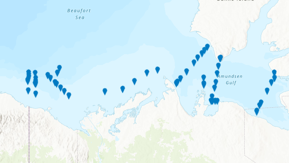
PURPOSE: From August 2nd to September 9th, 2013, Fisheries and Oceans Canada conducted a baseline survey of marine fishes and their habitats in the southern Canadian Beaufort Sea and Amundsen Gulf as part of the Beaufort Regional Environmental Assessment (BREA) called the Beaufort Sea Marine Fishes Project (BSMFP). Sampling was conducted from the F/V Frosti at 53 stations along 8 transects. Standardized sampling was conducted using benthic trawling nets. The BSMFP is the first research project to use a large research trawls to assess the biodiversity and abundance of offshore marine fishes in this area. In total, 48 species of fish were caught, one of which was a new occurrence in the Canadian Beaufort Sea, Lycodes lavalaei. DESCRIPTION: Basic biological data for all fish caught during the 2013 BSMFP expedition. Includes identification, weight, length (total, fork, and, standard), liver weight, gonad weight, sex and maturity level. PARAMETERS COLLECTED: family species weight total length fork length standard length liver weight gonad weight sex maturity SAMPLING METHODS: Various trawl types.
-

PURPOSE: From August 1st to September 11th, 2014, Fisheries and Oceans Canada conducted a baseline survey of marine fishes and their habitats in the southern Canadian Beaufort Sea and Amundsen Gulf as part of the Beaufort Regional Environmental Assessment (BREA) called the Beaufort Sea Marine Fishes Project (BSMFP). Sampling was conducted from the F/V Frosti at 54 stations along 14 transects. Standardized sampling was conducted at pre-determined depth stations (20-1500 m) using benthic trawling nets. The BSMFP is the first research project to use large research trawls to assess the biodiversity and abundance of offshore marine fishes in this area. In total, 42 species of fish were caught. This report contains information on fishing net deployments, catch per unit effort (CPUE), and basic biological data for all fishes caught. DESCRIPTION: Basic biological data for all fish caught during the 2014 BSMFP expedition. Includes identification, weight, length (total, fork, and, standard), liver weight, gonad weight, sex and maturity level. PARAMETERS COLLECTED: family species weight total length fork length standard length liver weight gonad weight sex maturity SAMPLING METHODS: Various trawl types.
-

Basic biological data for all fish caught during the 2012 BSMFP expedition. Includes identification, weight, length (total, fork, and, standard), liver weight, gonad weight, sex and maturity level.
-

From August 2nd to September 9th, 2013, Fisheries and Oceans Canada conducted a baseline survey of marine fishes and their habitats on the Canadian Beaufort Shelf and slope. Sampling was conducted from the F/V Frosti at 64 stations along ten transects. Standardized sampling was conducted on the transects at pre-determined depth stations (20-40, 75, 200, 350, 500, 750, and 1000 m) using a variety of sampling equipment including benthic fishing trawls, plankton nets, sediment cores, and CTD and water sample profiles. A specialized CTD probe (UCTD) was deployed at an additional 72 locations while the ship was underway.Presented here is the information on the sampling locations, and the sampling gear deployed at each station.