 Arctic SDI catalogue
Scientific survey
Type of resources
Topics
Keywords
Provided by
Representation types
Update frequencies
status
-

Since 1992, scientific surveys have been conducted annually alternately, in the estuary and the North of the Gulf of Saint Lawrence. These surveys allow DFO to monitor the population and ecosystem of the snow crab and thus understand the state of the stock and the renewal of the species. Beam trawl hauls following a systematic sampling take place every 2 years in the estuary and in the Lower North Shore. In the estuary (zone 17), a sampling of 94 stations is carried out. In the Lower North Shore (zone 13 and 14), 60 regular stations are usually sampled and 35 exploratory stations are distributed between Baie Johan Bettz and Kegaska (zone 15 and 16) but also on the south shore of zone 13 near Newfoundland. At each station, a fishing haul of 5 to 10 minutes is carried out. The harvested crabs are measured (cephalothorax width), sexed and counted. The state of the shell, sexual maturity and egg development stages are also assessed. The number of crabs caught, classified according to different size categories, allows estimating densities and thus monitoring the state and renewal of the snow crab population in the different fishing areas. This dataset on the snow crab (Chionoecetes opilio) contains abundance and density data of crabs under different size classes as well as geographical and bathymetric variables by station. The dataset covers the period from 1992 to the present and is updated each year. A cleaning of aberrant data has been carried out. For certain time periods, associated species are identified and semi-quantitatively counted directly on the sorting table, and the results are presented in the following publications: - https://open.canada.ca/data/en/dataset/8fbd81a4-ce4a-40e3-81f6-e2a5c44955de - https://open.canada.ca/data/en/dataset/268bf29e-b9d6-4267-bc86-230f4edfb80b - https://open.canada.ca/data/en/dataset/97dac757-2ef6-4144-b7d9-a0d8d51f8319
-
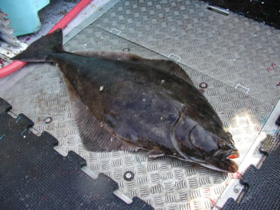
Since 2017, industry-supported scientific surveys targeting Atlantic halibut (Hippoglossus hippoglossus) have been conducted in the Gulf of St. Lawrence and parts of the estuary. The primary objective of the project is to gather data on the species' abundance, distribution, and biological characteristics. To achieve this, a stratified random longline survey is carried out, during which Atlantic halibut of all sizes are measured and tagged using two spaghetti tags. Beginning in 2024, tissue samples from the pelvic fin of each individual were also collected for genetic analysis. Atlantic halibut are captured using longlines equipped with 500 circle hooks. While the length of the leaders varies among vessels, the spacing between leaders ranges from 3.6 to 5.5 meters. Fork length is measured for each individual of commercial species caught - such as Atlantic halibut, cod, redfish, and Greenland halibut (turbot). Measurements are also occasionally taken for non-commercial species. This publication includes the file Donnees_Releve_Fletan_Halibut_Survey_Data, which provides information associated with each sampled station. It also contains the number of Atlantic halibut, cod, redfish and Greenland halibut (turbot) caught at each station. It is important to note that only beginning in 2019 were all commercial species systematically measured. The "NA" values in 2017–2018 do not indicate that no individuals were caught, but rather that they were not measured systematically. Note: There are missing data in various columns of the dataset - use data with caution - if you have any questions please contact the data management team gddaiss-dmsaisb@dfo-mpo.gc.ca.