 Arctic SDI catalogue
Trawl
Type of resources
Topics
Keywords
Contact for the resource
Provided by
Formats
Representation types
Update frequencies
status
-

PURPOSE: Trawl survey data used primarily for assessing the status of snow crab stocks in the southern Gulf of St. Lawrence. DESCRIPTION: Tow, catch, and biological information for snow crab and other species caught during the annual snow crab research vessel trawl survey in the southern Gulf of St. Lawrence. Currently, the survey uses a stratified random design that divides the area into 355 square grids, each measuring 12.7 km by 12.7 km. The survey area spans the majority of snow crab habitat in the southern Gulf, at depths ranging from 20 to 200 fathoms. Sampling stations are trawled during civil twilight hours using a Bigouden Nephrops bottom trawl net. The vessel operates at a target speed of 2 knots for a duration of 5 minutes, maintaining a warp-to-depth ratio of 3:1, with a maximum warp length of 575 fathoms. PARAMETERS COLLECTED: Snow crab: sex, carapace width, height of male crab claw, shell condition, gonad colour, egg colour, eggs remaining, and missing legs. Other species: counts, and weights Other: GPS coordinates; swept area; depth; temperature; CTD profile; NOTES ON QUALITY CONTROL: Data are checked for irregularities and errors. SAMPLING METHODS: Survey catches are sorted by species or taxonomic groups and measured directly on board. All snow crab are measured, while select fish species are measured only for a subset of survey stations. USE LIMITATION: To ensure scientific integrity and appropriate use of the data, we would encourage you to contact the data custodian.
-

PURPOSE: Used as an abundance index for use in stock assessment. DESCRIPTION: In 2015, a spawning ground acoustic survey that follows the design of the fishery-independent acoustic survey was initiated. This survey is the result of a partnership between DFO and fishery associations. The survey design uses random parallel transects within predefined strata. Surveys are conducted by fishermen in the fall fishing season according to protocols developed by DFO. The survey is conducted at night, during the weekend fishery closures except in Herring fishing area 16C and 16E in 2015 to 2017, where this region didn’t have weekend closures. The spawning ground acoustic survey is meant to provide a nightly estimate of spawning biomass among regions. It is analyzed in the same manner as the fishery-independent acoustic survey. The catches from the experimental nets are used to calibrate the spawning group specific target strength in order to obtain the nightly estimates of spawning biomass. PARAMETERS COLLECTED: Size and age measurement (biological); acoustic tracking (ecological); species counts (ecological) SAMPLING METHODS: See references. USE LIMITATION: To ensure scientific integrity and appropriate use of the data, we would encourage you to contact the data custodian.
-

A research survey on American lobster (Homarus americanus) and rock crab (Cancer irroratus) has been carried out annually on the Magdalen Islands since 1995 to assess the abundance and structure of populations in this area. The survey is carried out during the first two weeks of September and covers the southern part of the Magdalen Islands, from "Baie de Plaisance" to "Grande-Entrée", extending slightly eastwards between "Havre-aux-Maisons" and "Grande-Entrée". The survey lasts 8 to 15 days, depending of the weather conditions, and covers a maximum of 48 stations. Approximately half of the stations are surveyed in duplicate (two tows per station). The tows always cover 500 meters, with a slightly variable trawl opening (as explained above), averaging around 10 meters. The gear used is a Nephrops trawl, a benthic trawl originally developed for langoustine fishing in Brittany, but slightly modified to target lobster. The trawl is deployed from the CCGS Leim and the harvested organisms are hauled aboard and sorted. Cephalothorax length, sex and shell stage are recorded for all lobsters. This is supplemented by information on reproductive conditions for certain size classes, and dissections of 25 males and 25 females per mission. Rock crabs are also included in the survey and are counted with additional measurements of shell width, sex and shell condition that are recorded on predetermined stations. For other stations individuals data are collected depending on the time available between trawl hauls. The publication contains 4 files; the "Information_stations" file which contains the data of the stations, the "Data_homard_lobster_survey" file which contains the measurements of each lobster, the "Nombre_crabe_crab_number" file which contains the count of rock crabs, the "Mesure_crabe_crab_measurement" file contains the characteristics measured for each crab. Each of the files can be linked by the "date", "st", "tr" columns. The “bat” column notes the boat code, because the gear is not deployed in the same way on each boat. *This record consist of raw data and quality has not been verified Associated species are identified and semi-quantitatively counted directly on the sorting table, and the results are presented in the following publication: https://open.canada.ca/data/en/dataset/99cb7034-f3d5-4da4-a5bc-e81315cfb8eb
-

PURPOSE: Used as an abundance index for use in stock assessment. DESCRIPTION: Since 1991, an annual fishery-independent acoustic survey of early fall (September-October) concentrations of Herring has been conducted in the southern Gulf of St. Lawrence (sGSL). The standard annual survey area occurs in the 4Tmno areas where both NAFO Div. 4T Herring spawning components aggregate in the fall. The survey uses a random stratified design of parallel transects within predefined strata. Surveys are conducted at night and use two vessels: an acoustic vessel to quantify the fish schools' biomass using a hull-mounted 120 KHz split-beam transducer, and a fishing vessel to sample aggregates of fish with a pelagic trawl (details in LeBlanc et al. 2015; see also LeBlanc and Dale 1996). Trawl samples are used to separate the estimated biomass by spawning component and age, determine species composition, and size distribution for the estimation of the target strength (LeBlanc and Dale 1996; LeBlanc et al. 2015). A standardized abundance index is generated from this acoustic survey. This index includes catch-at-age data since 1994. This survey also provides the age-disaggregated acoustic abundance index for ages 2 to 10 for spring spawners and fall spawners. PARAMETERS COLLECTED: Size and age measurement (biological); acoustic tracking (ecological); species counts (ecological) SAMPLING METHODS: Please consult the research documents listed in the supplementary citation list for sampling details. USE LIMITATION: To ensure scientific integrity and appropriate use of the data, we would encourage you to contact the data custodian.
-

PURPOSE: Support age-structured population stock assessments and research on fish growth. DESCRIPTION: Fish otoliths are collected from scientific surveys, fisheries observers on fishing vessels and from scientific sampling of commercial fisheries. The otoliths collected are placed in paper envelopes, recorded and held in a climate-controlled storage facility. Atlantic herring otoliths are mounted and glued to acrylic trays. Age determination is performed yearly on available samples. Digital images of each pair of otoliths collected are captured when possible. The information made available through this metadata record is the summary of otoliths present in the collection at the Gulf Fisheries Centre in Moncton, NB, Canada. The number of otoliths available from different sources by year and month is provided for the following stocks: - Atlantic Cod, NAFO Divisions 4T / 4VN (Nov. to Apr.) - White Hake, NAFO Division 4T - American Plaice, NAFO Division 4T - Winter Flounder, NAFO Division 4T - Yellowtail Flounder, NAFO Division 4T - Witch Flounder, NAFO Divisions 4RST - Atlantic Herring, NAFO Division 4T - Skate species, NAFO Division 4T There is additional information of observed sex, length, weight and age information of fish specimens made by trained Fisheries and Oceans Canada technicians that can be made available upon request. PARAMETERS COLLECTED: length (biological), age (biological) NOTES ON QUALITY CONTROL: Reference collections for certain species exist and are used to train technicians and to calibrate the age readings obtained by the fisheries technicians that use the otoliths for age estimation. Digital images of the otoliths that are part of the reference collection are available and used for calibration and training purposes. The otolith images are also authoritatively annotated by fisheries technicians. PHYSICAL SAMPLE DETAILS: Fish otoliths, skate vertebrae SAMPLING METHODS: Marine fish otoliths are obtained from fish specimens collected during research surveys and during scientific sampling of commercial fisheries. The sagittal otoliths are removed from sampled specimens, recorded, placed in a protective medium and held in a climate-controlled storage facility. Digital images of each pair of otoliths collected are captured when possible. USE LIMITATION: To ensure scientific integrity and appropriate use of the data, we would encourage you to contact the data custodian.
-

Since 1992, scientific surveys have been conducted annually alternately, in the estuary and the North of the Gulf of Saint Lawrence. These surveys allow DFO to monitor the population and ecosystem of the snow crab and thus understand the state of the stock and the renewal of the species. Beam trawl hauls following a systematic sampling take place every 2 years in the estuary and in the Lower North Shore. In the estuary (zone 17), a sampling of 94 stations is carried out. In the Lower North Shore (zone 13 and 14), 60 regular stations are usually sampled and 35 exploratory stations are distributed between Baie Johan Bettz and Kegaska (zone 15 and 16) but also on the south shore of zone 13 near Newfoundland. At each station, a fishing haul of 5 to 10 minutes is carried out. The harvested crabs are measured (cephalothorax width), sexed and counted. The state of the shell, sexual maturity and egg development stages are also assessed. The number of crabs caught, classified according to different size categories, allows estimating densities and thus monitoring the state and renewal of the snow crab population in the different fishing areas. This dataset on the snow crab (Chionoecetes opilio) contains abundance and density data of crabs under different size classes as well as geographical and bathymetric variables by station. The dataset covers the period from 1992 to the present and is updated each year. A cleaning of aberrant data has been carried out. For certain time periods, associated species are identified and semi-quantitatively counted directly on the sorting table, and the results are presented in the following publications: - https://open.canada.ca/data/en/dataset/8fbd81a4-ce4a-40e3-81f6-e2a5c44955de - https://open.canada.ca/data/en/dataset/268bf29e-b9d6-4267-bc86-230f4edfb80b - https://open.canada.ca/data/en/dataset/97dac757-2ef6-4144-b7d9-a0d8d51f8319
-

PURPOSE: The primary objective of this survey is to obtain an index of the abundance and biomass of American lobster (Homarus americanus) in the Northumberland Strait. This research survey also provides fisheries-independent information for all of the species captured by the trawl. DESCRIPTION: Catch weight, length frequencies, and biological information for crustaceans and fish caught during the annual July-August research vessel trawl survey in Northumberland Strait (NAFO Division 4T). Abundance indices and spatial distribution patterns of commercial and non-commercial crustaceans and other groundfish. PARAMETERS COLLECTED: The full catch is sorted to species, or lowest taxonomic group possible, and weighed. For lobster, carapace length, sex and carapace condition (i.e. stage of moult) are recorded. For female lobster, the presence or absence of eggs is noted and, starting in 2010, the stage of development of the eggs (i.e. new or old) when present was also recorded. Similarly, for crabs, the carapace width, sex and carapace condition (i.e. stage of moult) is recorded as is the presence or absence of eggs (for females). Fish sampling varied over the years but, starting in 2005, length has been recorded for all fish captured. For large catches, the complete catch is sorted and weighed, but sub-sampling, by species, is used for the other measurements. NOTES ON QUALITY CONTROL: Data are checked for irregularities. SAMPLING METHODS: The Northumberland Strait multi-species survey began in 2001 using a stratified random sampling plan. A random selection of sampling sites within the study area is now used. Sampling is completed annually over a 4-week period in July and August. One hundred ten (110) stations are sampled in Northumberland Strait in water depths greater than 4 m at the lowest normal tide. The survey has employed a 286 Rockhopper trawl for all years from 2001 to 2018, except in 2010 and 2011, when a Nephrops trawl was used. In 2019, a new trawl (called the Northumberland trawl) was used in addition to the Rockhopper trawl. The Northumberland trawl is similar to the 286 Rockhopper trawl, but with a smaller footgear and smaller mesh sizes. At each station, the trawl is towed for a set period of time (recently 15 minutes with the rockhopper trawl and 10 minutes with the Northumberland trawl). USE LIMITATION: To ensure scientific integrity and appropriate use of the data, we would encourage you to contact the data custodian.
-

PURPOSE: The research survey provides a fisheries-independent source of information about all marine living organisms that are captured by the fishing trawl used to obtain samples in the southern Gulf of St. Lawrence. DESCRIPTION: Tow, catch, length frequency, and biological information for fish caught during the annual September research vessel trawl surveys in the southern Gulf of St. Lawrence (NAFO Division 4T). Abundance indices and spatial distribution patterns of commercial and non-commercial groundfish. The catch data that appear in this dataset SHOULD NOT BE USED FOR ECOLOGICAL ANALYSES INVOLVING CATCH RATES. Important factors such as vessel, fishing gear and diurnal periods must be accounted for to use these data in analyses. Please contact the data custodians if you are interested in using this data for any kind of ecological analyses involving catch rates. PARAMETERS COLLECTED: Abundance estimates (ecological); distribution (ecological); species counts (ecological); gear (fishing); vessel information (fishing); point (spatial) NOTES ON QUALITY CONTROL: Scientific names listed in the survey species list have been mapped to recognized standards - marine taxa have been mapped to the World Register of Marine Species (WoRMS) using their online taxon match tool. All sampling locations were plotted on a map to perform a visual check confirming that the latitude and longitude coordinates were within the described sampling area. In 2003, because of a fire aboard the Alfred Needler, the Wilfred Templeman was used for the survey. However, no comparative fishing experiments have been conducted between the Alfred Needler and the Wilfred Templeman. We are therefore unable to integrate the indices derived for 2003 to the remainder of the survey time-series. SAMPLING METHODS: Sampling Method: Consult the "Protocols for research vessel cruises within the Gulf Region (dermersal fish) (1970-1980)" report, link provided in the citations list. USE LIMITATION: To ensure scientific integrity and appropriate use of the data, we would encourage you to contact the data custodian.
-

PURPOSE: From August 1st to September 11th, 2014, Fisheries and Oceans Canada conducted a baseline survey of marine fishes and their habitats in the southern Canadian Beaufort Sea and Amundsen Gulf as part of the Beaufort Regional Environmental Assessment (BREA) called the Beaufort Sea Marine Fishes Project (BSMFP). Sampling was conducted from the F/V Frosti at 54 stations along 14 transects. Standardized sampling was conducted at pre-determined depth stations (20-1500 m) using benthic trawling nets. The BSMFP is the first research project to use large research trawls to assess the biodiversity and abundance of offshore marine fishes in this area. In total, 42 species of fish were caught. This report contains information on fishing net deployments, catch per unit effort (CPUE), and basic biological data for all fishes caught. DESCRIPTION: Basic biological data for all fish caught during the 2014 BSMFP expedition. Includes identification, weight, length (total, fork, and, standard), liver weight, gonad weight, sex and maturity level. PARAMETERS COLLECTED: family species weight total length fork length standard length liver weight gonad weight sex maturity SAMPLING METHODS: Various trawl types.
-
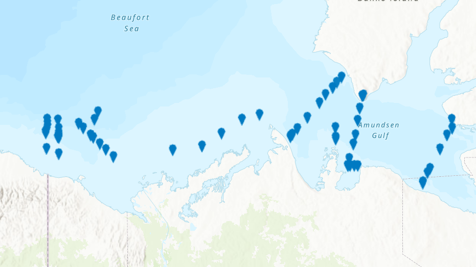
PURPOSE: From August 2nd to September 9th, 2013, Fisheries and Oceans Canada conducted a baseline survey of marine fishes and their habitats in the southern Canadian Beaufort Sea and Amundsen Gulf as part of the Beaufort Regional Environmental Assessment (BREA) called the Beaufort Sea Marine Fishes Project (BSMFP). Sampling was conducted from the F/V Frosti at 53 stations along 8 transects. Standardized sampling was conducted using benthic trawling nets. The BSMFP is the first research project to use a large research trawls to assess the biodiversity and abundance of offshore marine fishes in this area. In total, 48 species of fish were caught, one of which was a new occurrence in the Canadian Beaufort Sea, Lycodes lavalaei. DESCRIPTION: Basic biological data for all fish caught during the 2013 BSMFP expedition. Includes identification, weight, length (total, fork, and, standard), liver weight, gonad weight, sex and maturity level. PARAMETERS COLLECTED: family species weight total length fork length standard length liver weight gonad weight sex maturity SAMPLING METHODS: Various trawl types.