 Arctic SDI catalogue
Industry
Type of resources
Available actions
Topics
Keywords
Contact for the resource
Provided by
Formats
Representation types
Update frequencies
status
-

This list contains water meters operated by the City of Montreal Water Department. The meter pool is used to carry out water balances and makes it possible to measure the water distributed to the other municipalities forming the agglomeration of Montreal. This list is a view of the situation at the time the file was generated. NOTE: The data in this set aims to have a better understanding of the number of industrial, commercial and institutional water meters installed as part of the City of Montreal's water consumption measurement strategy. For reasons of challenges in the protection of third party industrial secrets, the consumption associated with these meters will not be published.**This third party metadata element was translated using an automated translation tool (Amazon Translate).**
-

The Oil and Gas Rights dataset contains the digital boundaries for existing exploration licences, significant discovery licences, production licences, former permits, former leases and the Norman Wells Proven Area. These boundaries are available for download on the Northern petroleum pesources Website at https://www.rcaanc-cirnac.gc.ca/eng/1100100036087/1538585604719. The Oil and Gas Rights dataset is Crown-Indigenous Relations and Northern Affairs Canada (CIRNAC) and Indigenous Services Canada (ISC) primary source for northern petroleum titles geographic location on maps.
-
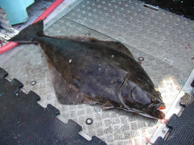
Since 2017, industry-supported scientific surveys targeting Atlantic halibut (Hippoglossus hippoglossus) have been conducted in the Gulf of St. Lawrence and parts of the estuary. The primary objective of the project is to gather data on the species' abundance, distribution, and biological characteristics. To achieve this, a stratified random longline survey is carried out, during which Atlantic halibut of all sizes are measured and tagged using two spaghetti tags. Beginning in 2024, tissue samples from the pelvic fin of each individual were also collected for genetic analysis. Atlantic halibut are captured using longlines equipped with 500 circle hooks. While the length of the leaders varies among vessels, the spacing between leaders ranges from 3.6 to 5.5 meters. Fork length is measured for each individual of commercial species caught - such as Atlantic halibut, cod, redfish, and Greenland halibut (turbot). Measurements are also occasionally taken for non-commercial species. This publication includes the file Donnees_Releve_Fletan_Halibut_Survey_Data, which provides information associated with each sampled station. It also contains the number of Atlantic halibut, cod, redfish and Greenland halibut (turbot) caught at each station. It is important to note that only beginning in 2019 were all commercial species systematically measured. The "NA" values in 2017–2018 do not indicate that no individuals were caught, but rather that they were not measured systematically. Note: There are missing data in various columns of the dataset - use data with caution - if you have any questions please contact the data management team gddaiss-dmsaisb@dfo-mpo.gc.ca.
-

The BC Indigenous Business Listings dataset offers a brief summary of Indigenous businesses operating in the province. For each business listed in the dataset, information including the Indigenous owner(s) of the company, location, links to websites as well as primary contact information including email addresses and phone numbers is provided where available. This information is intended to facilitate connections between business owners and consumers, investors, and industry. It is also meant to support an understanding of ownership trends among Indigenous businesses.