 Arctic SDI catalogue
Temps
Type of resources
Categories
Available actions
Keywords
Contact for the resource
Provided by
Years
Representation types
Update frequencies
status
Service types
-
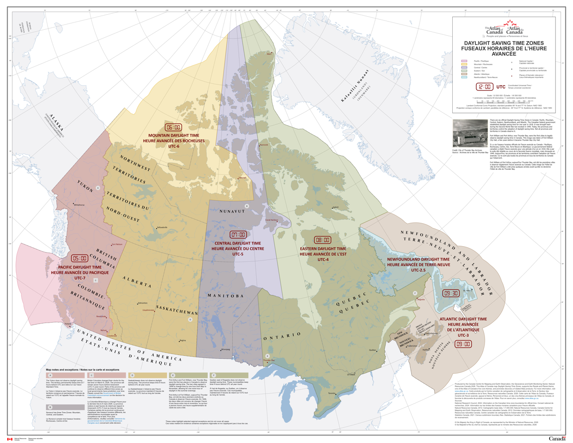
There are six official time zones in Canada: Pacific, Mountain, Central, Eastern, Newfoundland, and Atlantic. All time zone boundaries in Canada are regulated by the provinces and territories. This record contains maps and data for both legislated Standard Time and Daylight Saving Time boundaries. Daylight Saving Time occurs every year; it starts on the second Sunday in March and ends on the first Sunday in November. However, the Yukon, Saskatchewan and parts of British Columbia, Quebec and Nunavut do not observe Daylight Saving Time. The changes to Pacific time announced on March 2, 2026, by the Government of British Columbia are not reflected in this dataset. Please consult the [Government of British Columbia's announcement](https://news.gov.bc.ca/releases/2026AG0013-000209#:~:text=B.C.%27s%20new%20time%20zone,%20Pacific%20time,%20will,and%20other%20regions%20observing%20mountain%20standard%20time) for more information. The maps and data were produced by the Canada Centre for Mapping and Earth Observation (CCMEO) at Natural Resources Canada. The time zone boundary lines were created from information provided by the National Research Council who are responsible for official time in Canada.
-
GeoMet-Météo du SMC rend publiquement accessible les données du Service météorologique du Canada (SMC) et d'Environnement et Changement climatique Canada (ECCC) via des services web interopérables et des interfaces de programme (API). Par le biais de standards ouverts, ces services donnent rapidement et gratuitement accès à des milliers de jeux de données et produits météorologiques, climatiques et hydrométriques en temps réel et archivés qui peuvent être intégrés dans les applications spécifiques de l'usager et leurs systèmes d'aide à la décision. Les usagers peuvent développer des applications mobiles, créer des cartes interactives en-ligne, ainsi que de visualiser et animer les données du SMC dans des logiciels de bureau. Les services GeoMet du SMC rendent également possible le découpage de données et la reprojection sur demande, tout autant que la conversion de formats et la visualisation personnalisée de couches de données.
-

This mosaic is calculated over the North American domain with a horizontal spatial resolution of 1 km. This mosaic therefore includes all the Canadian and American radars available in the network and which can reach a maximum of 180 contributing radars. To better represent precipitation over the different seasons, this mosaic renders in mm/h to represent rain and in cm/h to represent snow. For the two precipitation types (rain and snow), we use two different mathematical relationships to convert the reflectivity by rainfall rates (mm/h rain cm/h for snow). This is a hybrid mosaic from DPQPE (Dual-Pol Quantitative Precipitation Estimation) for S-Band radars. For the US Nexrad radars, ECCC uses the most similar product from the US Meteorological Service (NOAA). This product displays radar reflectivity converted into precipitation rates, using the same formulas as the Canadian radars.
-

This product shows the rain accumulation, in mm, over the last 24 hour period based on DPQPE. This product is available every 6 minutes.
-

Current conditions and forecasts for selected Canadian cities. Raw XML data are used to generate each city page on the Environment Canada web site https://www.weather.gc.ca/.