 Arctic SDI catalogue
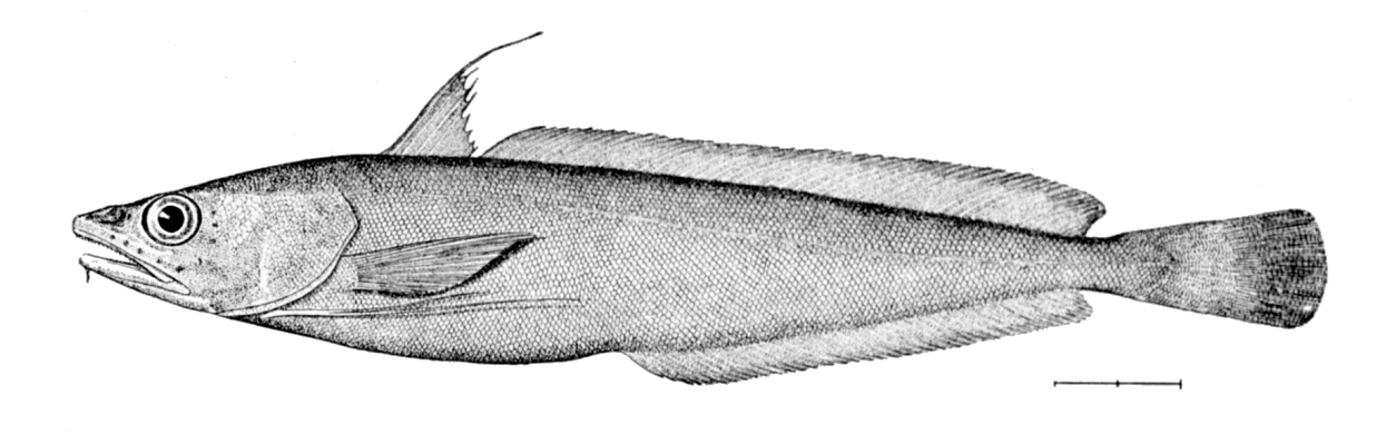
Urophycis tenuis
Type of resources
Topics
Keywords
Contact for the resource
Provided by
Formats
Representation types
Update frequencies
status
-

PURPOSE: Since 2003, a standardized otter trawl survey was conducted in August by commercial fishing vessels throughout the southern Gulf of St. Lawrence (NAFO Division 4T). The primary objective of this survey is to obtain abundance indices for the major commercial groundfish resources in the area. DESCRIPTION: Tow, catch, and length frequency for fish caught during the August sentinel surveys in the southern Gulf of St. Lawrence (NAFO Division 4T). Abundance indices and spatial distribution patterns of commercial groundfish. Note: Due to delays caused by logistic complexities and Covid, the project did not take place in 2020 PARAMETERS COLLECTED: Abundance estimates (ecological); distribution (ecological); species counts (ecological); gear (fishing); vessel information (fishing); point (spatial). NOTES ON QUALITY CONTROL: Scientific names listed in the survey species list have been mapped to recognized standards - marine taxa have been mapped to the World Register of Marine Species (WoRMS) using their online taxon match tool. All sampling locations were plotted on a map to perform a visual check confirming that the latitude and longitude coordinates were within the described sampling area. SAMPLING METHODS: For additional information on the sampling methods and supporting literature, please refer to the references provided USE LIMITATION: To ensure scientific integrity and appropriate use of the data, we would encourage you to contact the data custodian.
-

Summary The Quebec region of the Department of Fisheries and Oceans (DFO) is responsible for the assessment of several fish and invertebrate stocks exploited in the Estuary and the northern Gulf of St. Lawrence. The commercial catches sampling program is one of the sources of information used to complete these assessments. The data collected by this program, at wharf or at sea, offers among other things the advantage of a relatively large spatio-temporal coverage and provides some of the necessary knowledge to assess the demography and the structure of the exploited populations. This program is implemented by specialized DFO staff whose main mandate is to collect biological data on groundfish, pelagic fish and marine invertebrate species that are commercially exploited in the various marine communities. Data This dataset on the white hake (Urophycis tenuis) includes the metadata, sample weight, fish length, the sex and the number of specimens measured. This dataset covers the periods of 1989-1990 and 1992-1993. In order to protect the confidentiality of the sources, some informations (such as those concerning the vessel) have been excluded and others (such as the date of capture) have been simplified. Entries where there was only one vessel in a fishing area for a given year were also excluded. Further information including the fishing areas coordinates can be found by clicking on the «Atlantic and Arctic commercial fisheries» and «Fishing areas» links below.
-

PURPOSE: Support age-structured population stock assessments and research on fish growth. DESCRIPTION: Fish otoliths are collected from scientific surveys, fisheries observers on fishing vessels and from scientific sampling of commercial fisheries. The otoliths collected are placed in paper envelopes, recorded and held in a climate-controlled storage facility. Atlantic herring otoliths are mounted and glued to acrylic trays. Age determination is performed yearly on available samples. Digital images of each pair of otoliths collected are captured when possible. The information made available through this metadata record is the summary of otoliths present in the collection at the Gulf Fisheries Centre in Moncton, NB, Canada. The number of otoliths available from different sources by year and month is provided for the following stocks: - Atlantic Cod, NAFO Divisions 4T / 4VN (Nov. to Apr.) - White Hake, NAFO Division 4T - American Plaice, NAFO Division 4T - Winter Flounder, NAFO Division 4T - Yellowtail Flounder, NAFO Division 4T - Witch Flounder, NAFO Divisions 4RST - Atlantic Herring, NAFO Division 4T - Skate species, NAFO Division 4T There is additional information of observed sex, length, weight and age information of fish specimens made by trained Fisheries and Oceans Canada technicians that can be made available upon request. PARAMETERS COLLECTED: length (biological), age (biological) NOTES ON QUALITY CONTROL: Reference collections for certain species exist and are used to train technicians and to calibrate the age readings obtained by the fisheries technicians that use the otoliths for age estimation. Digital images of the otoliths that are part of the reference collection are available and used for calibration and training purposes. The otolith images are also authoritatively annotated by fisheries technicians. PHYSICAL SAMPLE DETAILS: Fish otoliths, skate vertebrae SAMPLING METHODS: Marine fish otoliths are obtained from fish specimens collected during research surveys and during scientific sampling of commercial fisheries. The sagittal otoliths are removed from sampled specimens, recorded, placed in a protective medium and held in a climate-controlled storage facility. Digital images of each pair of otoliths collected are captured when possible. USE LIMITATION: To ensure scientific integrity and appropriate use of the data, we would encourage you to contact the data custodian.
-
Integrating Gut Microbiota and Population Genomics in White Hake (Urophycis tenuis): Supporting Data
PURPOSE: The purpose of this work was to determine (1) how the population genomic structure relates to gut microbiota composition of White Hake (Urophycis tenuis), and (2) whether microbiota community variation provides complementary insights into population structure of this species in eastern Canada. DESCRIPTION: Integrating host-associated microbiota with genomic approaches offers an opportunity to better understand the multiple biological dimensions shaping population structure in marine fishes. A clear understanding of population structure and dynamics is essential for informed fisheries management and conservation decisions; however, while genomic approaches have greatly improved our ability to delineate biological populations, they provide only a partial representation of biological structure, as patterns of differentiation reflect both historical divergence and contemporary ecological conditions. Host-associated microbiota can influence population-level ecological processes by contributing functional, potentially heritable variation that shapes host phenotype and fitness. In this study, we combined genotyping-by-sequencing with 16S rRNA gene amplicon sequencing to examine how population genomic structure relates to gut microbiota composition and to evaluate whether microbiota community variation provides complementary insights into population structure in White Hake (Urophycis tenuis) in eastern Canada. Genomic analyses identified two populations with greater spatial overlap than previously reported. Variation partitioning revealed that host genetics explained a negligible proportion of microbiota variation compared to environmental factors and fish length, suggesting that ontogenetic shifts in habitat use and resource acquisition influence gut microbiota composition. Several taxa were differentially abundant among fish length categories used as a proxy for diet, including taxa with chitin-degrading potential such as Photobacterium and Lachnospirales, which were enriched in smaller fish known to consume a crustacean-dominated diet. Together, these results indicate that gut microbiota composition in White Hake primarily reflects ecological and life-history processes rather than host population structure. PARAMETERS COLLECTED: Environmental parameters were also collected at most sampling sites, including depth, water temperature, oxygen and salinity levels. PHYSICAL SAMPLE DETAILS: Fin samples were collected to characterize the fish genotypes. Intestine (rectum) samples were collected to study fish gut microbiome. SAMPLING METHODS: In 2022 and 2023, White Hake were sampled during Fisheries and Oceans Canada (DFO) annual bottom trawl ecosystem monitoring surveys. USE LIMITATION: To ensure scientific integrity and appropriate use of the data, we would encourage you to contact the data custodian.
-

PURPOSE: The primary objective of this survey is to obtain an index of the abundance and biomass of American lobster (Homarus americanus) in the Northumberland Strait. This research survey also provides fisheries-independent information for all of the species captured by the trawl. DESCRIPTION: Catch weight, length frequencies, and biological information for crustaceans and fish caught during the annual July-August research vessel trawl survey in Northumberland Strait (NAFO Division 4T). Abundance indices and spatial distribution patterns of commercial and non-commercial crustaceans and other groundfish. PARAMETERS COLLECTED: The full catch is sorted to species, or lowest taxonomic group possible, and weighed. For lobster, carapace length, sex and carapace condition (i.e. stage of moult) are recorded. For female lobster, the presence or absence of eggs is noted and, starting in 2010, the stage of development of the eggs (i.e. new or old) when present was also recorded. Similarly, for crabs, the carapace width, sex and carapace condition (i.e. stage of moult) is recorded as is the presence or absence of eggs (for females). Fish sampling varied over the years but, starting in 2005, length has been recorded for all fish captured. For large catches, the complete catch is sorted and weighed, but sub-sampling, by species, is used for the other measurements. NOTES ON QUALITY CONTROL: Data are checked for irregularities. SAMPLING METHODS: The Northumberland Strait multi-species survey began in 2001 using a stratified random sampling plan. A random selection of sampling sites within the study area is now used. Sampling is completed annually over a 4-week period in July and August. One hundred ten (110) stations are sampled in Northumberland Strait in water depths greater than 4 m at the lowest normal tide. The survey has employed a 286 Rockhopper trawl for all years from 2001 to 2018, except in 2010 and 2011, when a Nephrops trawl was used. In 2019, a new trawl (called the Northumberland trawl) was used in addition to the Rockhopper trawl. The Northumberland trawl is similar to the 286 Rockhopper trawl, but with a smaller footgear and smaller mesh sizes. At each station, the trawl is towed for a set period of time (recently 15 minutes with the rockhopper trawl and 10 minutes with the Northumberland trawl). USE LIMITATION: To ensure scientific integrity and appropriate use of the data, we would encourage you to contact the data custodian.
-

PURPOSE: The research survey provides a fisheries-independent source of information about all marine living organisms that are captured by the fishing trawl used to obtain samples in the southern Gulf of St. Lawrence. DESCRIPTION: Tow, catch, length frequency, and biological information for fish caught during the annual September research vessel trawl surveys in the southern Gulf of St. Lawrence (NAFO Division 4T). Abundance indices and spatial distribution patterns of commercial and non-commercial groundfish. The catch data that appear in this dataset SHOULD NOT BE USED FOR ECOLOGICAL ANALYSES INVOLVING CATCH RATES. Important factors such as vessel, fishing gear and diurnal periods must be accounted for to use these data in analyses. Please contact the data custodians if you are interested in using this data for any kind of ecological analyses involving catch rates. PARAMETERS COLLECTED: Abundance estimates (ecological); distribution (ecological); species counts (ecological); gear (fishing); vessel information (fishing); point (spatial) NOTES ON QUALITY CONTROL: Scientific names listed in the survey species list have been mapped to recognized standards - marine taxa have been mapped to the World Register of Marine Species (WoRMS) using their online taxon match tool. All sampling locations were plotted on a map to perform a visual check confirming that the latitude and longitude coordinates were within the described sampling area. In 2003, because of a fire aboard the Alfred Needler, the Wilfred Templeman was used for the survey. However, no comparative fishing experiments have been conducted between the Alfred Needler and the Wilfred Templeman. We are therefore unable to integrate the indices derived for 2003 to the remainder of the survey time-series. SAMPLING METHODS: Sampling Method: Consult the "Protocols for research vessel cruises within the Gulf Region (dermersal fish) (1970-1980)" report, link provided in the citations list. USE LIMITATION: To ensure scientific integrity and appropriate use of the data, we would encourage you to contact the data custodian.
-

Each summer, environmental community groups collect important data to determine if groupings of fish, shrimp and crab – what is called a community- can be used as an indicator of the health status of bays and estuaries. Sampling was conducted from May through September for the first years then from June through August. In 2018 and 2019, the sampling was conducted just once in each estuary. Community group members and staff sample six stations once a month in their designated estuary. Fish, shrimps and crabs are collected with a beach seine net and later released live back to the water once identified and counted. From this, the community groups provide important information to Fisheries and Oceans Canada, including: - identification and numbers of fish, shrimp and crab species; - water conditions and samples; - information on aquatic plants; - sediment samples. With this information, Fisheries and Oceans Canada scientists working with government agencies and universities can conduct analyses to determine the suitability of indicators to assess the health of bays and estuaries. PARAMETERS COLLECTED: Parameters: abundance, species richness, species developmental stage (young-of-the-year or adult), water temperature, water salinity, water dissolved oxygen, dissolved inorganic nutrient (nitrate, nitrite, phosphate), sediment % organic content, sediment % humidity content and sediment mean grain size, % submerged aquatic vegetation cover NOTES ON QUALITY CONTROL: Data entry into Excel and first quality control verification is done by CAMP summer students. A second quality control verification is done by DFO staff. See publ # 2823 attached to this record. In 2018, the historical data was migrated into a relationship database. From this year on, annual data will be entered into the database using a custom application. The application front end has numerous QC elements built-in. SAMPLING METHODS: Please see the following URL for sampling details: http://www.dfo-mpo.gc.ca/Library/319437.pdf