 Arctic SDI catalogue
geoscientific information
Type of resources
Available actions
Topics
Keywords
Contact for the resource
Provided by
Formats
Representation types
Update frequencies
status
-

This data set is the ArcInfo version of the Nova Scotia Mineral Occurrence Database. The data set was compiled by the Geoscience and Mines Branch of the Nova Scotia Department of Natural Resources and Renewables. This digital product was developed from the databases contained in Digital Product DP ME 1b. DP ME 2 contains a series of attribute tables that contain information about the various mineral occurrences present in the province of Nova Scotia. It includes information such as: types of alteration, sample analyses information, mineral commodities, coordinates, element and mineral type, mode of mineralization, NTS mapsheet information, element sampling information, stratigraphic units, types of surveys carried out and work done on the occurrence.
-
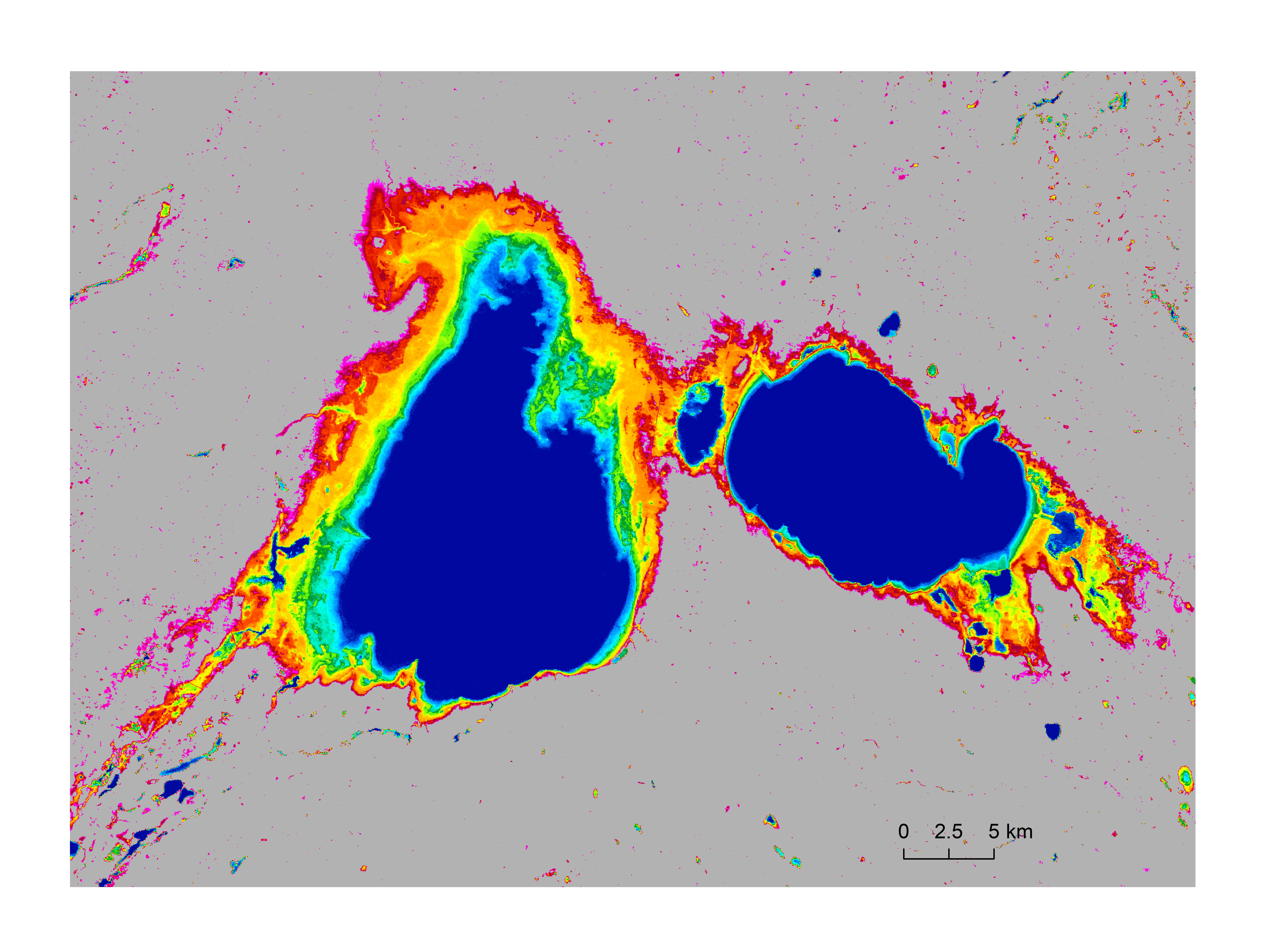
Data represents surface water occurrence frequency (percentage), which describes the frequency for each grid appeared as water in the 30 years time period of 1991 to 2020. The data covers Canada’s entire landmass including all transboundary watersheds, and is at 30-meter spatial resolution. The surface water occurrence frequency is derived using the surface water model of Wang et al. (2023) from all-available monthly water data observed by the Landsat satellites (Pekel et al., 2016). Here, permanent waters are represented by 100%, and permanent land surfaces by 0%, of water occurrence for a 30-meter by 30-meter grid. References: Pekel, J.-F., A. Cottam, N. Gorelick, A.S. Belward, 2016, High-resolution mapping of global surface water and its long-term changes. Nature, 540, 418-422. Wang, S., J. Li, and H. A. J. Russell, 2023, Methods for Estimating Surface Water Storage Changes and Their Evaluations. Journal of Hydrometeorology, DOI: https://doi.org/10.1175/JHM-D-22-0098.1.
-
This digital product (Version 1 released as DP ME 92-03) is a digital version of Nova Scotia Published Map ME 92-3, Surficial Geology Map of the Province of Nova Scotia, compiled by R. R. Stea, H. Conley and Y. Brown, 1992. The digital product was digitized from Map ME 1992-3 and the databases were developed from the information contained on this map. The digital product contains layers for surficial geology features such as: beaches, cirques, deltas, drumlins, eskers, surficial geologic units, hummocks, kettles, moraines, meltwater, roche moutonnees, terrace scarps, glacial striations and other geological features. Version 2 of the product was released in 2006 in NAD83 and contained a number of thematic layers which were not included in Version 1.
-
This digital product is developed from a database of published drillhole information for the province of Nova Scotia. The database is maintained by the Nova Scotia Department of Natural Resources and Renewables, Geoscience and Mines Branch. The database was developed from information contained in publicly available mineral exploration assessment reports, open file reports and other Natural Resources and Renewables and Geological Survey of Canada (GSC) publications. The database provides approximate coordinate locations for many of the drillholes, and also provides a source reference on each drillhole. The digital product contains a layer for the drillholes.
-
A sinkhole is a natural depression or hole in the Earth's surface which may have various causes. Most natural sinkholes are caused by the chemical dissolution of water-soluble carbonate rocks or gypsum. Sinkholes may vary in size from 1 to 600 m both in diameter and depth. Sinkholes may be formed gradually or by sudden collapse and are found worldwide in ‘karst areas.’ Karst areas are not unique to Nova Scotia; in fact, they occur in over a quarter of the earth’s surface. As a result, there are well-established methods for reducing karst risks. These include actions that can be taken both at the planning and construction stage of a project, as well as on-going actions that reduce the risk of future sinkhole formation. This dataset was developed to show areas of Nova Scotia where there is a relatively high-medium-low risk of encountering karst and naturally occurring sinkholes caused by soluble bedrock.
-
This digital product is developed from a database of published abandoned mine openings for the province of Nova Scotia. The database is maintained by the Nova Scotia Department of Natural Resources and Renewables, Geoscience and Mines Branch. The database provides approximate coordinate locations for many of the abandoned mine openings, and also provides a source reference on each mine opening.
-
The Department of Natural Resources and Renewables (NRR) (formerly the Department of Energy and Mines) and Nova Scotia Environment and Climate Change (ECC) maintains an electronic Well Log Database which contains water well construction and location information for water wells in the Province of Nova Scotia. Information in the database is entered from original paper copies of well logs that are submitted by certified well drillers and well diggers to ECC. This version of the database was extracted on January 5, 2022 and contains 125,517 well logs constructed between 1940 and 2021, inclusive.
-
This digital product is a digital version of Published Map ME 2000-01, Geological Map of the Province of Nova Scotia, compiled by J. D. Keppie, 2000. The digital product was created by Geoscience and Mines Branch staff. The original data was compiled and digitized from over 60 maps and sources of information that are noted on the map. The GIS databases were developed from the information contained on this map. The digital product contains layers for geological features such as: bedrock geologic units, faults, geological contacts, isotope ages, other geological features.