 Arctic SDI catalogue
Integrated Marine Response Planning (IMRP)
Type of resources
Topics
Keywords
Contact for the resource
Provided by
Formats
Representation types
Update frequencies
status
-
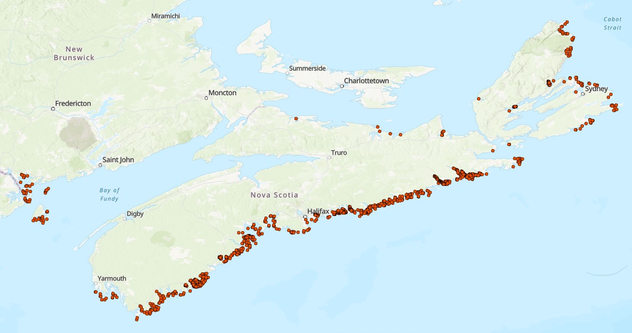
This is a collection of eelgrass (Zostera marina) presence and absence records collected between 2009-2025 in coastal waters in Nova Scotia, Canada. The data collection has been collated by the Coastal Benthic Ecology Lab (CBEL) at the Bedford Institute of Oceanography, Fisheries and Oceans Canada (DFO) under the supervision of Dr. Melisa Wong. Records include those from various research groups at DFO, Nova Scotia provincial departments, academia, and non-profit organizations. Data were collected using various methods including field measurements of eelgrass presence or absence via boat, snorkel and drop camera video transects, surface observations, and various sample collections (including plants, core, sediment, trawl, pop net, seine, etc.). Please see specific record references for associated metadata and detailed descriptions of the methods for eelgrass occurrence data collection. Where available, water depth (m) and substrate type (rock, soft, or mixed) are provided. The substrate type (hard substrate, mixed, mud, rocky, sand, or various combinations) used for the species distribution model published by O’Brien et al. 2022 is also provided where available. The data owner, data source (i.e., reference(s)), and use of the data in the species distribution model of O’Brien et al. 2022 are provided. All records from sources external to DFO are included under data sharing agreements or permission from the data owner. Cite this data as: Wong, M.C., Fraser, M., Thomson, J. A., O’Brien, J. Data of eelgrass (Zostera marina) occurrences in Nova Scotia. Published: April 2026. Coastal Ecosystems Science Division, Maritimes Region, Fisheries and Oceans Canada, Dartmouth NS.
-

Appropriately responding to a marine pollution event, especially hydrocarbon spills, often requires detailed knowledge of local habitat and environmental features. Access to high resolution habitat profiles can support effective spill response plans, informing discussions on protection priorities or expediated remediation. However, marine habitat composition data for a given area is often lacking due to the high cost and effort of conducting such surveys across the vast shorelines of Canada. The purpose of this study was to develop methodologies for conducting rapid and affordable habitat compositions in the marine environment via drone aerial photography; an emerging technology for conducting high resolution surveys. We used the Musquash Marine Protected Area (MPA; Musquash, NB, Canada) as a model system as it contains a diverse range of habitat types, is a region of conservation concern in Atlantic Canada, and is in close proximity to oil and gas handling facilities and vessel traffic. The MPA consists of a tidal river that outflows into the Bay of Fundy. Using Geographic Information System (GIS) software, we subdivided the MPA into several transects (N =61) that were used to generate flight plans for a Remotely Piloted Aircraft System (RPAS; DJI Mavic 3 Enterprise, DJI ). The RPAS was flown (6 m s-1) at an altitude of 100m (Above ground level) taking images with side (70%) and front (80%) overlap. Resulting images were then compiled as an orthomosaic map using Pix4Dmatic software. These data will be used to inform marine spill response planning in the region, to support marine planning and conservation, and Marine Protected Area (MPA) monitoring efforts as well as develop further methodological approaches for conducting RPAS-based habitat surveys in other coastal systems within Atlantic Canada. Cite this data as: Lawrence MJ, Coates PJ, Matheson K, Hamer A. Characterisation of intertidal habitat types in the Musquash Marine Protected Area using aerial drone photography. Published November 2025. Coastal Ecosystems Science Division, Fisheries and Oceans Canada, St. Andrews, N.B.