 Arctic SDI catalogue
natural area
Type of resources
Available actions
Topics
Keywords
Contact for the resource
Provided by
Years
Formats
Resolution
-
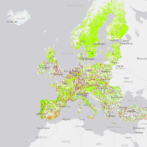
Riparian zones represent transitional areas occurring between land and freshwater ecosystems, characterised by distinctive hydrology, soil and biotic conditions and strongly influenced by the stream water. They provide a wide range of riparian functions (e.g. chemical filtration, flood control, bank stabilization, aquatic life and riparian wildlife support, etc.) and ecosystem services. The Riparian Zones products support the objectives of several European legal acts and policy initiatives, such as the EU Biodiversity Strategy to 2020, the Habitats and Birds Directives and the Water Framework Directive. This metadata refers to the Riparian Zones Land Cover/Land Use (LC/LU) change for 2012-2018. The LC/LU classification is tailored to the needs of biodiversity monitoring in a variable buffer zone of selected rivers (Strahler levels 2-9 derived from EU-Hydro) for the change layer 2012-2018. LC/LU is extracted from Very High Resolution (VHR) satellite data and other available data in a buffer zone of selected rivers for supporting biodiversity monitoring and mapping and assessment of ecosystems and their services. The class definitions follow the pre-defined nomenclature on the basis of Mapping and Assessment of Ecosystems and their Services (MAES) typology of ecosystems (Level 1 to Level 4) and CORINE Land Cover. The classification provides 55 distinct thematic classes with a Minimum Mapping Unit (MMU) of 0.5 ha and a Minimum Mapping Width (MMW) of 10 m. The production of the Riparian Zones products was coordinated by the European Environment Agency in the frame of the EU Copernicus programme.
-

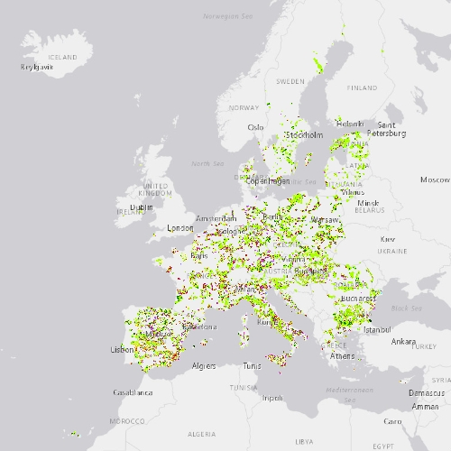
This metadata refers to CLMS N2K 2012 product, the Copernicus Land Cover/Land Use (LC/LU) status map, with 2012 as reference year for the classification, tailored to the needs of biodiversity monitoring in selected Natura2000 sites: 4790 sites of natural and semi-natural grassland formations listed in Annex I of the Habitats Directive, including a 2 km buffer zone surrounding the sites and covering an area of 631.820 km² across Europe (EU27, the United Kingdom and Switzerland). The product includes three Emerald sites in Switzerland. LC/LU has been extracted from VHR satellite data and other available data. This metadata specifically refers to the revision of the 2012 N2K status map carried out during the production of the 2018 update. The production of N2K updates was coordinated by the European Environment Agency (EEA) in the frame of the EU Copernicus programme.
-

This metadata refers to CLMS N2K 2006 product, the Copernicus Land Cover/Land Use (LC/LU) status map, with 2006 as reference year for the classification, tailored to the needs of biodiversity monitoring in selected Natura2000 sites: 4790 sites of natural and semi-natural grassland formations listed in Annex I of the Habitats Directive, including a 2 km buffer zone surrounding the sites and covering an area of 631.820 km² across Europe (EU27, the United Kingdom and Switzerland). The product includes three Emerald sites in Switzerland. LC/LU has been extracted from VHR satellite data and other available data. This metadata specifically refers to the revision of the 2006 N2K status map carried out during the production of the 2018 update. The production of N2K updates was coordinated by the European Environment Agency (EEA) in the frame of the EU Copernicus programme.
-
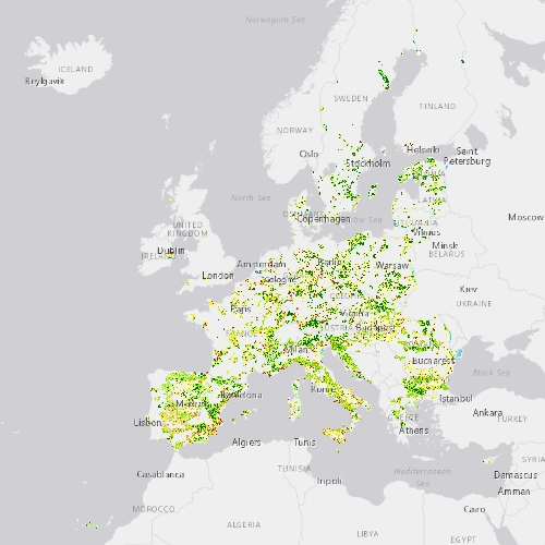
This metadata refers to the CLMS N2K Change 2006-2012 product, the Copernicus Land Cover/Land Use (LC/LU) change map tailored to the needs of biodiversity monitoring in selected Natura2000 sites: 4790 sites of natural and semi-natural grassland formations listed in Annex I of the Habitats Directive, including a 2km buffer zone surrounding the sites. The change mapping exercise between the reference years 2006 and 2012, based on the outputs of the status layers, occurred over an area of 631.800 km² across Europe (i.e. EU27, the United Kingdom and Switzerland). The change dataset only shows the areas that have changed between 2006 and 2012, covering an area of 1.054.684 ha. LC/LU is extracted from VHR satellite data and other available data. Change detection is based on the analysis of VHR satellite data from the reference years 2006 ±2 years and 2012 ±2 years. The production of N2K updates was coordinated by the European Environment Agency (EEA) in the frame of the EU Copernicus programme.
-
This metadata refers to the CLMS N2K Change 2012-2018 product, the Copernicus Land Cover/Land Use (LC/LU) change map tailored to the needs of biodiversity monitoring in selected Natura2000 sites: 4790 sites of natural and semi-natural grassland formations listed in Annex I of the Habitats Directive, including a 2km buffer zone surrounding the sites. The change mapping exercise between the reference years 2012 and 2018, was based on the comparison of VHR satellite data and occurred over an area of 631.800 km² across Europe (i.e. EU27, the United Kingdom and Switzerland). The change dataset only shows the areas that have changed between 2012 and 2018 and covers an area of 1.199.652 ha. LC/LU is extracted from VHR satellite data and other available data. Change detection is based on the analysis of VHR satellite data from the reference years 2012 ±2 years and 2018 ±1 year. The production of N2K updates was coordinated by the European Environment Agency (EEA) in the frame of the EU Copernicus programme.
-
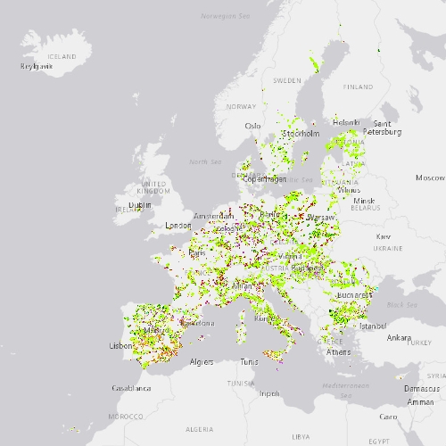
This metadata refers to CLMS N2K 2018 product, the Copernicus Land Cover/Land Use (LC/LU) status map, with 2018 as reference year for the classification, tailored to the needs of biodiversity monitoring in selected Natura2000 sites: 4790 sites of natural and semi-natural grassland formations listed in Annex I of the Habitats Directive, including a 2 km buffer zone surrounding the sites and covering an area of 631.820 km² across Europe (EU27, the United Kingdom and Switzerland). The product includes three Emerald sites in Switzerland. LC/LU has been extracted from VHR satellite data and other available data. The production of N2K updates was coordinated by the European Environment Agency (EEA) in the frame of the EU Copernicus programme.