 Arctic SDI catalogue
Biodiversity
Type of resources
Available actions
Topics
Keywords
Contact for the resource
Provided by
Years
Formats
Representation types
Update frequencies
status
Service types
Scale
Resolution
-
#abstract#
-
-
-
-

Marine classification schemes based on abiotic surrogates often inform regional marine conservation planning in lieu of detailed biological data. However, theses chemes may poorly represent ecologically relevant biological patterns required for effective design and management strategies. We used a community-level modeling approach to characterize and delineate representative mesoscale (tens to thousands of kilometers) assemblages of demersal fish and benthic invertebrates in the North-west Atlantic. Hierarchical clustering of species occurrence data from four regional annual multispecies trawl surveys revealed three to six groupings (predominant assemblage types) in each survey region, broadly associated with geomorphic and oceanographic features. Indicator analyses identified 3–34 emblematic taxa of each assemblage type. Random forest classifications accurately predicted assemblage dis-tributions from environmental covariates (AUC > 0.95) and identified thermal limits (annual minimum and maximum bottom temperatures) as important pre-dictors of distribution in each region. Using forecasted oceanographic conditions for the year 2075 and a regional classification model, we projected assemblage dis-tributions in the southernmost bioregion (Scotian Shelf-Bay of Fundy) under ahigh emissions climate scenario (RCP 8.5). Range expansions to the north eastare projected for assemblages associated with warmer and shallower waters of the Western Scotian Shelf over the 21st century as thermal habitat on the rela-tively cooler Eastern Scotian Shelf becomes more favorable. Community-level modeling provides a biotic-informed approach for identifying broadscale ecolog-ical structure required for the design and management of ecologically coherent, representative, well-connected networks of Marine Protected Areas. When com-bined with oceanographic forecasts, this modeling approach provides a spatial tool for assessing sensitivity and resilience to climate change, which can improve conservation planning, monitoring, and adaptive management. Cite this data as: O'Brien, J.M., Stanley, R.R.E., Jeffery, N.W., Heaslip, S.W., DiBacco, C., and Wang, Z. Demersal fish and benthic invertebrate assemblages in the Northwest Atlantic. Published: December 2024. Coastal Ecosystems Science Division, Maritimes region, Fisheries and Oceans Canada, Dartmouth NS. https://open.canada.ca/data/en/dataset/14d55ea5-b17d-478c-b9ee-6a7c04439d2b
-

The Geonetwork Catalog of the Arctic Biodiversity Data Service (ABDS) https://abds.is/ is an integral component of the Conservation of Arctic Flora and Fauna (CAFF) initiative https://www.caff.is/. CAFF is a working group of the Arctic Council dedicated to addressing the conservation challenges facing Arctic biodiversity and promoting sustainable management practices in the region. As part of CAFF's mandate, the ABDS aims to provide a comprehensive and accessible repository of biodiversity-related data and information specific to the Arctic. The Geonetwork Catalog within ABDS serves as a centralized platform for discovering, accessing, and sharing geospatial datasets relevant to Arctic biodiversity conservation and management. It hosts a diverse range of spatial data layers, including species distribution maps, habitat classifications, ecosystem assessments, land cover maps, and more. These datasets are sourced from various contributors, including scientific research projects, monitoring programs, government agencies, indigenous knowledge holders, and non-governmental organizations. Hereafter you can find the WMS, WFS and GeoNetwork connections.
-
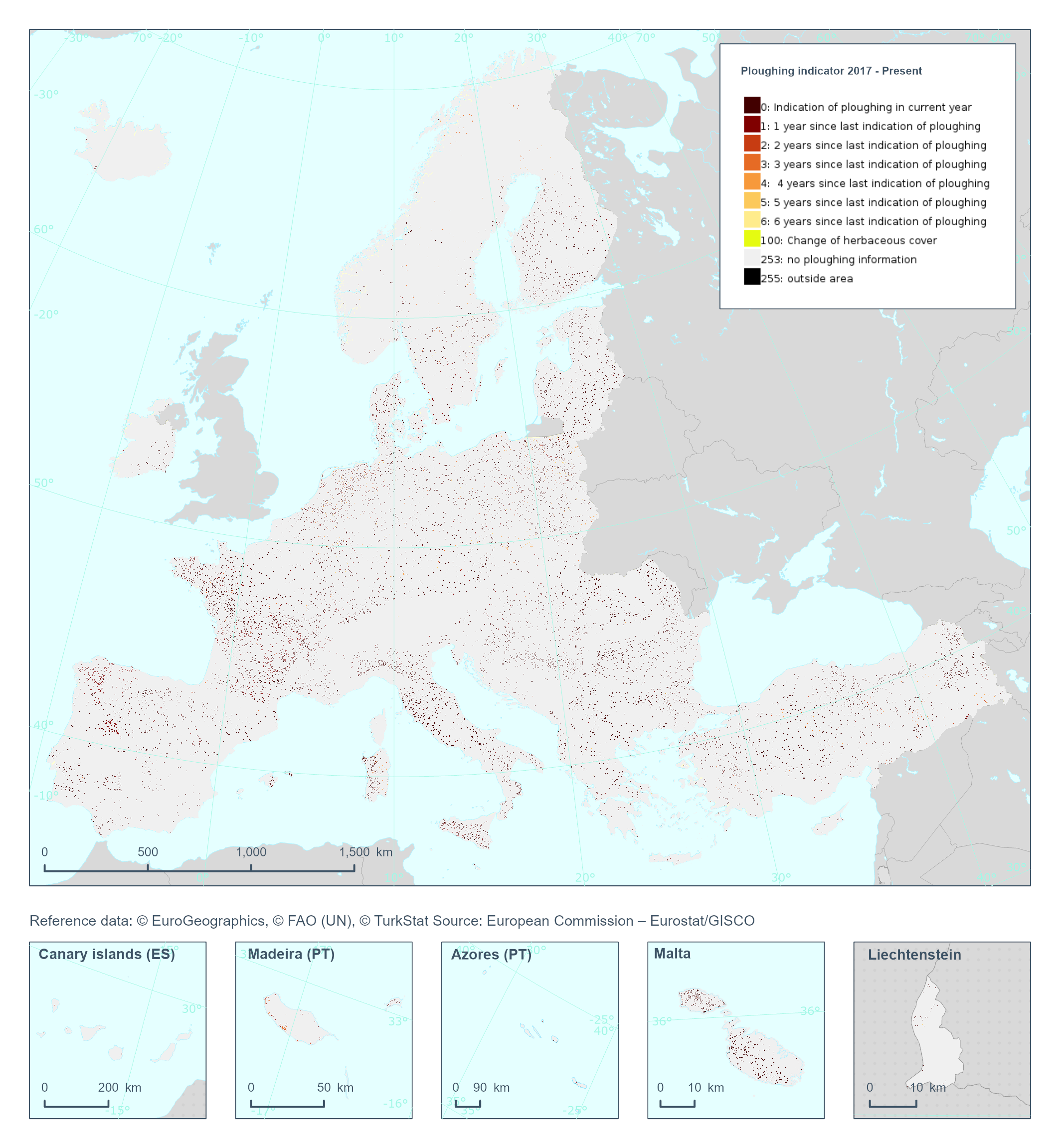
The High Resolution Layer Ploughing indicator (PLOUGH) raster product continues the 2015 and 2018 PLOUGH Layer following a rolling archive principle by adding current information and removing historic years. It indicates the number of years since the last indication of ploughing within the permanent grassland area. PLOUGH is derived by taking into account the series of binary HER layers, the BVL classifications and HR VPP PPI (Plant Phenology Index) quantiles. BVL classes 4 (crop) and 7 (overlaying layer between herbaceous and crop) indicate a ploughing event. Low HR VPP PPI quantiles indicate low vegetation at a certain time of the year. For years with missing information (2016 and earlier) the ploughing information from the historic PLOUGH product is considered which causes some issues. This dataset is provided annually starting in 2017 with 10 meter rasters (fully conformant with the EEA reference grid) in 100 x 100 km tiles covering the EEA38 countries. High Resolution Layer Grasslands product is part of the European Union’s Copernicus Land Monitoring Service. This dataset includes data from the French Overseas Territories (DOMs)
-

This theme presents observations of invasive exotic species (IAS) transmitted and validated using the Sentinelle tool, an EEE detection system. An invasive exotic species is a plant, animal or microorganism (virus, bacteria or fungi) that are introduced outside of their natural range. Son establishment or its spread may pose a threat to the environment, the economy or society. The species listed are species of fauna and flora concerning (or potentially worrying) for Quebec's biodiversity. Elles include EEE present in Quebec and EEE not listed in Quebec at monitor.**This third party metadata element was translated using an automated translation tool (Amazon Translate).**
-
The Quebec Natural Heritage Data Center (CDPNQ) is the most comprehensive information management system on species in a precarious situation in Quebec. It broadcasts more than 6,700 occurrences of floristic species for 506 species in a precarious situation. This information is the source data used to generate ranges. By definition, a range is a generalized geographic area where a species occurs without taking into account its particular habitat needs. This information is particularly useful for planning inventories or supporting the planning of conservation projects. The creation of ranges for all species in precarious situations in Quebec is an exercise that can be particularly complex, due in particular to the number of species involved, the evolutionary nature of the geomatic information available and the natural spatial distribution of species. The project for the automated creation of distribution areas was developed in order to avoid the problems raised previously. This approach makes it possible to provide, for all plant species in precarious situations in Quebec, a product that is standardized, reliable, easily reproducible and much easier to maintain. Each range has up to three “zones”: “presence,” “historical,” and “possible presence.” These three zones are defined according to the viability ratings and the level of precision of the occurrences of the species present in each ecological district.**This third party metadata element was translated using an automated translation tool (Amazon Translate).**
-
The data represent the distribution of species of amphibians, reptiles, reptiles, terrestrial mammals and freshwater and migratory fish in Quebec. The files represent: amphibians: 21 species terrestrial mammals: 69 species freshwater and migratory fish: 118 species reptiles: 17 species The ranges were established on the basis of various sources of information and validated by the Main Directorate of expertise on terrestrial fauna (DPEFT), the Main Directorate for Threatened or Vulnerable Species (DPEMV) and the Main Directorate of Expertise on Aquatic Wildlife (DPEFA) of the Ministry of the Environment, the Fight against Climate Change, Climate Change, Wildlife and Parks (MELCCFP). The ranges of species of _freshwater and migratory fish_ are also illustrated in the [“Freshwater Fish of Quebec”] poster (https://cdn-contenu.quebec.ca/cdn-contenu/faune/documents/animaux/affiche-poissons-eau-douce.pdf). Some ranges have been slightly modified since they were included in the poster. __There may be differences between the ranges of the species shown in the files and the current spatial distribution of the species. __ The distribution areas were produced on a small scale; they provide indicative information on the presence of the species in Quebec. The cards are the property of MELCCFP. __Atten:__ The ranges of marine mammals that frequent the coasts of the province of Quebec are not included in this dataset.**This third party metadata element was translated using an automated translation tool (Amazon Translate).**