 Arctic SDI catalogue
opendata
Type of resources
Available actions
Keywords
Contact for the resource
Provided by
Years
Formats
status
Service types
-
Hydrographical measurements (pressure, temperature, salinity) undertaken within German sole survey in the North Sea. The dataset contains temperature and salinity profiles taken at haul positions. The data are interpolated vertically into 1-m depth intervals.Data are structured in 2D. However, by the value of water pressure the vertical axis is given.
-
The survey aims to collect data on distribution and relative abundance, with biological information, on commercial and other fish and invertebrate species in the German exclusive economic zone in the North Sea. Possible changes due to the increasing industrialization are to be detected. An annual exchange between the demersal trawl and the beam trawl is taking place.Gear: Demersal trawl (Cod hopper) with 200 mm rubber discs, 20 mm mesh in the cod-end, haul duration 30 min7 meter beam trawl with 5 ticklers, 20 mm mesh in the cod-end, 80 mm mesh in the net, haul duration 15 min.Data are structured in 2D. However, by the value of water pressure the vertical axis is given.
-
Hydrographical measurements undertaken within german Winter Crangon Survey (WCG) in the southern North Sea. The dataset contains temperature and salinity profiles taken at haul positions. The data are interpolated vertically into 1-m depth intervals.Data are structured in 2D. However, by the value of water pressure the vertical axis is given.
-
Hydrographical measurements (pressure, temperature, salinity) undertaken within German Greenland Survey. The dataset contains temperature and salinity profiles taken at haul positions. The data are interpolated vertically into 1-m depth intervals.Data are structured in 2D. However, by the value of water pressure the vertical axis is given.
-
Dieser Dienst stellt für das INSPIRE-Thema Gewässernetz (Hydro-Physische Gewässer) aus ATKIS Basis-DLM umgesetzte Daten bereit.
-

Dieser Dienst stellt für das INSPIRE-Thema Gewässernetz (Hydro-Physische Gewässer) aus ALKIS umgesetzte Daten bereit.
-
.png)
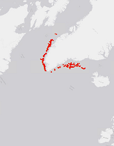
The WMS MSSP-EEZ (INSPIRE) represents marine seismic survey profiles for the German EEZ. During the period from 1996 to 2007 five cruises operated by BGR acquired seismic lines from the German EEZ. The aim of these cruises was a detailed survey of the geological structure of the seabed from the North Sea and Baltic Sea. According to the Data Specification on Geology (D2.8.II.4_v3.0, subtopic Geophysics) the content of the information with respect to the seismic profiles is INSPIRE-compliant. The WMS MSSP-EEZ (INSPIRE) contains for each cruise one layer, e.g. GE.seismicLine.pq2. The expeditions are displayed correspondingly to the INSPIRE portrayal rules. Via the getFeatureInfo request the user obtains the content of the INSPIRE attributes platformType und profileType. Additionally, the WMS contains a campaign layer (GE.2DSeismicSurvey) with the INSPIRE attributes campaignType and surveyType.