 Arctic SDI catalogue
stock assessment
Type of resources
Topics
Keywords
Contact for the resource
Provided by
Formats
Representation types
Update frequencies
status
-
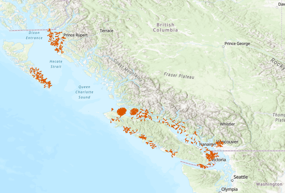
The Department of Fisheries and Oceans (DFO) Science Branch has designed a multispecies dive survey protocol to provide unbiased, coast wide monitoring of benthic invertebrate stocks (as may be required under the updated Fisheries Act) and associated habitat information for a suite of benthic marine invertebrate species (Green (Strongylocentrotus droebachiensis), Purple (S. purpuratus) and Red Sea Urchin (Mesocentrotus franciscanus), Geoduck (Panopea generosa), Giant Red Sea Cucumber (Apostichopus californicus), Northern Abalone (Haliotis kamtschatkana), and Sunflower Sea Star (Pycnopodia helianthoides)). Based on information available at this time, the proposed survey design can provide estimates of coast wide stock status for Red Sea Urchin and Giant Red Sea Cucumber, and relative abundance indices for Geoduck, Green Sea Urchin, Purple Sea Urchin, Northern Abalone and Sunflower Sea Star. The new protocol was tested through a series of pilot surveys conducted on a subset of areas of the BC coast each September from 2016-2021. Design of the pilot surveys was based on previous dive survey data and experience and demonstrated the practical feasibility of the protocol, while also gathering preliminary information to guide recommendations about the statistical design of the survey. The dataset consists of a relational database containing tables representing each component of the survey methodology. The primary component of the survey is a transect location. Along each transect, systematically spaced quadrats are sampled, and on each quadrat, substrate observations are recorded, multiple species of algae are recorded, and multiple individual invertebrates are measured or counted. The tables are linked by transect number and quadrat number.
-

PURPOSE: An aerial survey of the Western Hudson Bay beluga whale (Delphinapterus leucas) population was conducted on August 19th, 2015 to provide a population estimate. Surveys were flown in a DeHavilland Twin Otter (DH-6) fitted with four bubble windows and an optical glass-covered camera hatch at the rear underbelly of the plane. A Global Positioning System (GPS) unit logged the position, altitude, speed, and heading of the aircraft each second. Surveys were initially flown at a target ground speed of 100 knots (185 km/h), and target altitudes of 1,000 ft (305 m) for visual surveys and 2,000 ft (610 m) for photographic surveys. After the second day of flying, the target ground speed was adjusted to 110 knots (204 km/h). Complete coverage of the two photographic strata was achieved using a Nikon D810 camera fitted with a 25 mm lens. The camera was mounted at the rear of the aircraft and directed straight down with the longest side perpendicular to the track line. The camera was connected to a GPS unit to geo-reference photographs, and to a laptop computer to control exposure settings and photo interval. At an altitude of 2,000 ft (610 m), the 25 mm lens captured a ground area of approximately 875 m x 585 m. The photograph interval was set to maintain an overlap of 20 to 40 % between consecutive photos, and with a transect spacing of 600 m, the lateral overlap between photos from adjacent transects was approximately 30 %. DESCRIPTION: Aerial surveys of summering Western Hudson Bay (WHB) beluga (Delphinapterus leucas) were conducted on August 19th, 2015 to update the previous population abundance. The survey area comprised five strata (three visual and two photographic) encompassing high use areas around three river estuaries where recurring aggregations of WHB beluga are found during the summer months. This metadata covers the photographic data related to the survey. The photographic surveys completely covered high density aggregations in the Churchill River and near the mouth of the Seal River.
-

PURPOSE: An aerial survey of the Western Hudson Bay beluga whale (Delphinapterus leucas) population was conducted on August 12th, 2015 to provide a population estimate. Surveys were flown in a DeHavilland Twin Otter (DH-6) fitted with four bubble windows and an optical glass-covered camera hatch at the rear underbelly of the plane. A Global Positioning System (GPS) unit logged the position, altitude, speed, and heading of the aircraft each second. Surveys were initially flown at a target ground speed of 100 knots (185 km/h), and target altitudes of 1,000 ft (305 m) for visual surveys and 2,000 ft (610 m) for photographic surveys. After the second day of flying, the target ground speed was adjusted to 110 knots (204 km/h). Complete coverage of the two photographic strata was achieved using a Nikon D810 camera fitted with a 25 mm lens. The camera was mounted at the rear of the aircraft and directed straight down with the longest side perpendicular to the track line. The camera was connected to a GPS unit to geo-reference photographs, and to a laptop computer to control exposure settings and photo interval. At an altitude of 2,000 ft (610 m), the 25 mm lens captured a ground area of approximately 875 m x 585 m. The photograph interval was set to maintain an overlap of 20 to 40 % between consecutive photos, and with a transect spacing of 600 m, the lateral overlap between photos from adjacent transects was approximately 30 %. DESCRIPTION: Aerial surveys of summering Western Hudson Bay (WHB) beluga (Delphinapterus leucas) were conducted on August 12th, 2015 to update the previous population abundance. The survey area comprised five strata (three visual and two photographic) encompassing high use areas around three river estuaries where recurring aggregations of WHB beluga are found during the summer months. This metadata covers the photographic data related to the survey. The photographic surveys completely covered high density aggregations in the Churchill River and near the mouth of the Seal River.