 Arctic SDI catalogue
Government of Canada; Natural Resources Canada
Type of resources
Available actions
Topics
Keywords
Contact for the resource
Provided by
Years
Formats
Representation types
Update frequencies
status
Service types
-

Flood extent polygons from past years in selected Canadian regions that have been designated for observation, monitored by Natural Resources Canada using satellite imagery for emergency response. Coverage is not comprehensive nationwide. In response to large flood events, Natural Resources Canada (NRCan), for the provision of emergency geomatics services, may be activated by Canada’s emergency management protocols. As new satellite imagery becomes available, NRCan will extract flood extent polygons and update the dataset in near real time (4 hours). This item contains the complete archive of all flood products generated since 2005, by NRCan's emergency geomatics services. For any data to the current year, please refer to the catalogue entry entitled: [Floods in Canada – Current]( https://open.canada.ca/data/en/dataset/b1afd8d2-6e14-4ec4-9a09-652221a6cb71). The flood products generated are validated on a best effort basis. Various factors may affect the quality of the flood polygons. These factors include, but are not limited to, sensor type, image resolution, cloud cover or limitations of the flood polygon extraction method. In this layer, where possible, a symbology is applied to the flood polygons based on the underlying land use classification, or is simply unclassified and shows the raw flood extent. When using Web mapping services, to display a specific product, filter by date (UTC Date) and area of interest (AOI). Also, a link to download each product directly from the FTP site is available in the Resources section. This prepackaged and compressed product contains a Shape file, a PDF file and a KMZ file. For more information on past flooding events, please refer to the catalog entry entitled: [Historical Flood Events (HFE)](https://geo.ca/flood-mapping/flood-map-gallery/historical-flood-events/) Disclaimer: Emergency response authorities are the primary users of these satellite-derived open water flood extent map products. These products are generated to provide analysis and emergency response situational awareness and to facilitate decision-making during major flood events. The open water flood extent products are generated rapidly and limited time is available for editing and validation. The flood products reflect the open water flood conditions at the date/time of acquisition. While efforts are made to produce high quality products, near-real time products may contain errors due to the limited time available for vector editing and validation. Please note that current algorithms do not map flooded areas under the forest canopy and are not optimized for urban flood mapping. Limitation of Liability: Accordingly, the information contained on this website is provided on an “as is” basis and Natural Resources Canada makes no representations or warranties respecting the information, either expressed or implied, arising by law or otherwise, including but not limited to, effectiveness, completeness, accuracy or fitness for a particular purpose. Natural Resources Canada does not assume any liability in respect of any damage or loss based on the use of this website. In no event shall Natural Resources Canada be liable in any way for any direct, indirect, special, incidental, consequential, or other damages based on any use of this website or any other website to which this site is linked, including, without limitation, any lost profits or revenue or business interruption. Parent Collection: - **[Floods in Canada - Cartographic Product Collection](https://open.canada.ca/data/en/dataset/08b810c2-7c81-40f1-adb1-c32c8a2c9f50)**
-
Collection of monitoring products of river ice roughness from current and past winter seasons throughout Canada as monitored by Natural Resources Canada using satellite imagery. This collection of cartographic products regroups river ice state monitoring products and their associated footprints. Three visualization timeframes are available: - **[Active Monitoring of River Ice in Canada](https://open.canada.ca/data/en/dataset/7b210c58-2fc7-47c5-8b8a-2605c77d725c)** - **[River Ice in Canada - Current](https://open.canada.ca/data/en/dataset/8ca6f047-ddef-43d7-81c2-47654f4c69bd)** - **[River Ice in Canada - Archive](https://open.canada.ca/data/en/dataset/5e6b40bf-299f-4e05-87c8-d10b9c8210f9)**
-

Collection of flood products for active and past floods throughout Canada as monitored by Natural Resources Canada using satellite imagery for emergency response. This collection of cartographic products regroups flood extent polygons and their associated footprints. Three visualization timeframes are available : - **[Active Floods in Canada](https://open.canada.ca/data/en/dataset/9cad712a-5ac5-4248-b7d7-2db1a3892509)** - **[Floods in Canada - Current Year](https://open.canada.ca/data/en/dataset/b1afd8d2-6e14-4ec4-9a09-652221a6cb71)** - **[Floods in Canada - Archive](https://open.canada.ca/data/en/dataset/74144824-206e-4cea-9fb9-72925a128189)**
-

Flood extent polygons from the last three days in selected Canadian regions that have been designated for observation, monitored by Natural Resources Canada using satellite imagery for emergency response. Coverage is not comprehensive nationwide. In response to large flood events, Natural Resources Canada (NRCan), for the provision of emergency geomatics services, may be activated by Canada’s emergency management protocols. As new satellite imagery becomes available, NRCan will extract flood extent polygons and update the dataset in near real time (4 hours). This item contains the latest flood products generated in the past three days. For any data older than 72 hours, please refer to the [Floods in Canada - Current Year](https://open.canada.ca/data/en/dataset/b1afd8d2-6e14-4ec4-9a09-652221a6cb71) entry. Note that the web mapping service may not display data if flood polygons have not been published by the EGS in the past three days. The flood products generated are validated on a best effort basis. Various factors may affect the quality of the flood polygons. These factors include, but are not limited to, sensor type, image resolution, cloud cover or limitations of the flood polygon extraction method. In this layer, where possible, a symbology is applied to the flood polygons based on the underlying land use classification, or is simply unclassified and shows the raw flood extent. When using Web mapping services, to display a specific product, filter by date (UTC Date) and area of interest (AOI). Also, a link to download each product directly is available in the Resources section. This prepackaged and compressed product contains a Shape file, a PDF file and a KMZ file. Disclaimer: Emergency response authorities are the primary users of these satellite-derived open water flood extent map products. These products are generated to provide analysis and emergency response situational awareness and to facilitate decision-making during major flood events. The open water flood extent products are generated rapidly and limited time is available for editing and validation. The flood products reflect the open water flood conditions at the date/time of acquisition. While efforts are made to produce high quality products, near-real time products may contain errors due to the limited time available for vector editing and validation. Please note that current algorithms do not map flooded areas under the forest canopy and are not optimized for urban flood mapping. Limitation of Liability: Accordingly, the information contained on this website is provided on an “as is” basis and Natural Resources Canada makes no representations or warranties respecting the information, either expressed or implied, arising by law or otherwise, including but not limited to, effectiveness, completeness, accuracy or fitness for a particular purpose. Natural Resources Canada does not assume any liability in respect of any damage or loss based on the use of this website. In no event shall Natural Resources Canada be liable in any way for any direct, indirect, special, incidental, consequential, or other damages based on any use of this website or any other website to which this site is linked, including, without limitation, any lost profits or revenue or business interruption. Parent Collection: - **[Floods in Canada - Cartographic Product Collection](https://open.canada.ca/data/en/dataset/08b810c2-7c81-40f1-adb1-c32c8a2c9f50)**
-
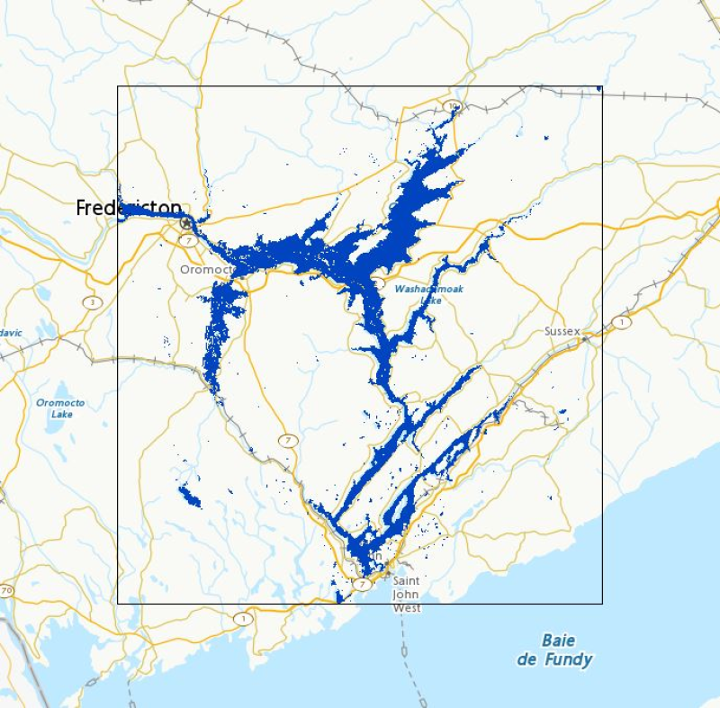
Flood extent polygons from the current calendar year in selected Canadian regions that have been designated for observation, monitored by Natural Resources Canada using satellite imagery for emergency response. Coverage is not comprehensive nationwide. In response to large flood events, Natural Resources Canada (NRCan), for the provision of emergency geomatics services, may be activated by Canada’s emergency management protocols. As new satellite imagery becomes available, NRCan will extract flood extent polygons and update the dataset in near real time (4 hours). This item contains the flood products generated in the past year. For any data relating to previous years, please refer to the [Floods in Canada – Archive]( https://open.canada.ca/data/en/dataset/74144824-206e-4cea-9fb9-72925a128189) entry. Please note that the web mapping service may not display data if flood polygons have not been published by the EGS for the current year. The flood products generated are validated on a best effort basis. Various factors may affect the quality of the flood polygons. These factors include, but are not limited to, sensor type, image resolution, cloud cover or limitations of the flood polygon extraction method. In this layer, where possible, a symbology is applied to the flood polygons based on the underlying land use classification, or is simply unclassified and shows the raw flood extent. When using Web mapping services, to display a specific product, filter by date (UTC Date) and area of interest (AOI). Also, a link to download each product is available in the Resources section. This prepackaged and compressed product contains a Shape file, a PDF file and a KMZ file. Disclaimer : Emergency response authorities are the primary users of these satellite-derived open water flood extent map products. These products are generated to provide analysis and emergency response situational awareness and to facilitate decision-making during major flood events. The open water flood extent products are generated rapidly and limited time is available for editing and validation. The flood products reflect the open water flood conditions at the date/time of acquisition. While efforts are made to produce high quality products, near-real time products may contain errors due to the limited time available for vector editing and validation. Please note that current algorithms do not map flooded areas under the forest canopy and are not optimized for urban flood mapping. Limitation of Liability : Accordingly, the information contained on this website is provided on an “as is” basis and Natural Resources Canada makes no representations or warranties respecting the information, either expressed or implied, arising by law or otherwise, including but not limited to, effectiveness, completeness, accuracy or fitness for a particular purpose. Natural Resources Canada does not assume any liability in respect of any damage or loss based on the use of this website. In no event shall Natural Resources Canada be liable in any way for any direct, indirect, special, incidental, consequential, or other damages based on any use of this website or any other website to which this site is linked, including, without limitation, any lost profits or revenue or business interruption. Parent Collection: - **[Floods in Canada - Cartographic Product Collection](https://open.canada.ca/data/en/dataset/08b810c2-7c81-40f1-adb1-c32c8a2c9f50)**
-
The Environmental Assessment (EA) projects layer includes all projects for which an environmental assessment under the Canadian Environmental Assessment Act, 2012 is ongoing. The location of a project included in the dataset is approximate based on information provided by proponents. More than one location may be identified for a given project. This dataset does not include information related to the project footprint. Additional information on EA projects included in this dataset is available on the Project Home Page and in the project description documents on the Canadian Environmental Assessment Registry Internet site.
-
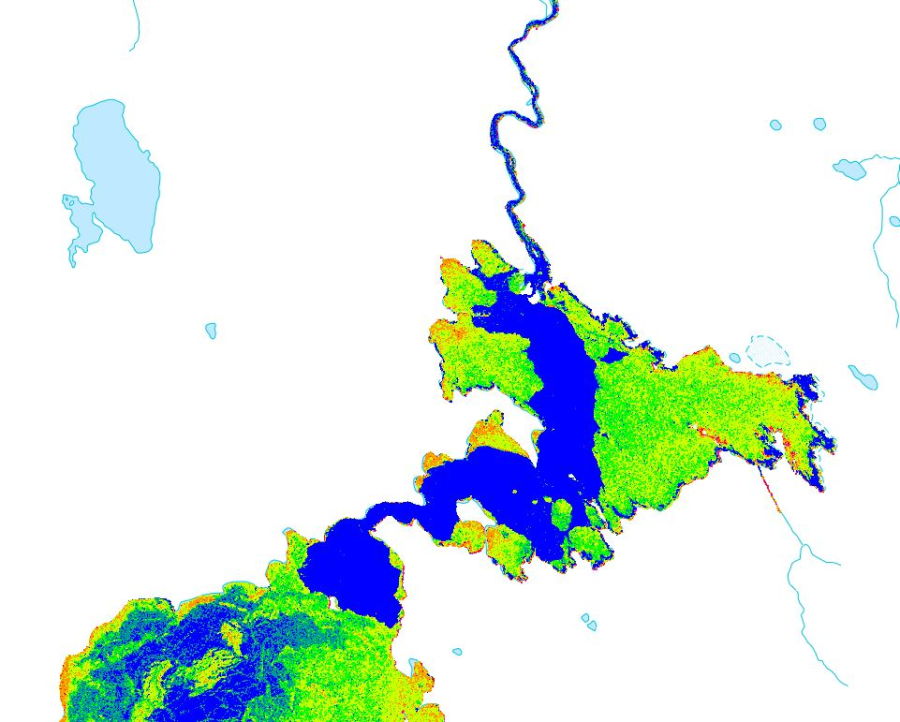
<DIV STYLE="text-align:Left;"><DIV><DIV><P STYLE="margin:0 0 14 0;"><SPAN>The dataset time series presented by this web service corresponds to daily (subsampled to a monthly interval) snow cover percentage at 1km resolution grid over land areas of Canada from 2006-2010. The data are subsampled by 4km to reduce data volumes and considering the geolocation uncertainty of the input satellite imagery. The daily maps are generated by assimilation of daily cloud screened NOAA AVHRR satellite imagery and Canadian Meteorological Centre (CMC) snow depth analysis snow depth and density fields within an off-line version of the CMC daily snow depth model. The snow depth model is modified to include snowpack reflectance model and a surface radiative transfer scheme that relates vegetation and snowpack reflectance to top-of-canopy bi-directional reflectance. A logistic vegetation phenology model is used to parameterize temporal dynamics of canopy leaf area index. A per-pixel particle filter with a 30 day moving window is applied to assimilation observations corresponding to 1km resolution visible band directional reflectance and normalized difference vegetation index and 24km CMC daily snow depth and monthly snow density fields. The assimilation is forced using daily air temperature and precipitation fields. Validation of the datasets has been performed by comparison to MODIS snow cover maps and in-situ snow depth stations across Canada. Validation suggests similar accuracy to MODIS snow cover products over relatively flat terrain.</SPAN></P><P STYLE="margin:0 0 14 0;"><SPAN><SPAN>The source data is accessible at </SPAN></SPAN><A href="https://neodf.nrcan.gc.ca/neodf_cat3/"><SPAN><SPAN>https://neodf.nrcan.gc.ca/neodf_cat3/</SPAN></SPAN></A></P><P><SPAN /></P></DIV></DIV></DIV>
-
Location of Major Infrastructure, Resource, Oil and Gas Projects in Nunavut, Northwest Territories and Yukon. Data and maps for illustrative purposes only.
-
Flood extent polygons representing past floods throughout Canada as monitored by Natural Resources Canada using satellite imagery for emergency response. In response to large flood events, Natural Resources Canada, for the provision of emergency geomatics services (NRCan), may be activated by Canada’s emergency management protocols. This item contains past years archive of the flood products generated by NRCan emergency geomatics services. The flood products are generated and validated on a best effort basis. Various factors may affect the quality of the flood polygons. Those factors include but are not limited to: sensor type, image resolution, cloud coverage or limits to the flood polygon extraction method. In this layer, a symbology is applied to the flood polygons based on the underlying land use classification, when available, or is simply unclassified and shows the gross flood extent otherwise. Filter on date and Area of Interest (AOI) to view specific products. Time-enabled on Date UTC field. ".zip" file packages that contain the shapefile, PDF map, and ".kmz" of individual product items are available through the FTP links listed in the Package URL field. Disclaimer: Emergency response authorities are the primary users of these satellite-derived open water flood extent map products. These products are generated to provide analysis and emergency response situational awareness and to facilitate decision-making during major flood events. The open water flood extent products are generated rapidly and limited time is available for editing and validation. The flood products reflect the open water flood conditions at the date/time of acquisition. While efforts are made to produce high quality products, near-real time products may contain errors due to the limited time available for vector editing and validation. Please note that current algorithms do not map flooded areas under the forest canopy and are not optimized for urban flood mapping. Limitation of Liability: Accordingly, the information contained on this website is provided on an “as is” basis and Natural Resources Canada makes no representations or warranties respecting the information, either expressed or implied, arising by law or otherwise, including but not limited to, effectiveness, completeness, accuracy or fitness for a particular purpose. Natural Resources Canada does not assume any liability in respect of any damage or loss based on the use of this website. In no event shall Natural Resources Canada be liable in any way for any direct, indirect, special, incidental, consequential, or other damages based on any use of this website or any other website to which this site is linked, including, without limitation, any lost profits or revenue or business interruption.
-
This service shows the percentage of the population who reported an Aboriginal identity by census division. The data is from the Census Profile, Statistics Canada Catalogue no. 98-316-X2016001. Aboriginal identity refers to whether the person identified with the Aboriginal peoples of Canada. This includes those who are First Nations (North American Indian), Métis or Inuk (Inuit) and/or those who are Registered or Treaty Indians (that is, registered under the Indian Act of Canada) and/or those who have membership in a First Nation or Indian band. Aboriginal peoples of Canada are defined in the Constitution Act, 1982, section 35 (2) as including the Indian, Inuit and Métis peoples of Canada. Users should be aware that the estimates associated with this variable are more affected than most by the incomplete enumeration of certain Indian reserves and Indian settlements in the 2016 Census of Population.