 Arctic SDI catalogue
Electricity
Type of resources
Available actions
Topics
Keywords
Contact for the resource
Provided by
Formats
Representation types
Update frequencies
status
-

The Remote Communities Energy Database (RCED) is a tool that aims to collect and show pertinent information about the generation and use of electricity and other energy sources for all remote communities of Canada. This data is collected from a variety sources, including Statistics Canada, Provincial and Territorial Governments, utilities, public reports and communities. The term “remote community” refers to any community not currently connected to the North American electrical grid nor to the piped natural gas network; and which is a permanent or long-term (five years or more) settlement with at least 10 dwellings. Disclaimer: Natural Resources Canada (NRCan) accepts no responsibility or liability for any errors, inaccuracies and/or omissions in the Remote Communities Energy Database (RCED). The content of the RCED is a compilation of data obtained from many sources and the data is subject to change without notice. Neither does NRCan warrant or guarantee that the information is accurate, complete or current at all times. In no event will NRCan or the Government of Canada and its employees be liable or responsible for any damages resulting from any such errors, inaccuracies or omissions nor will they be liable or responsible for any lost profits, loss of revenue or earnings, claims by third parties or for any economic, indirect, special, incidental, consequential or exemplary damage including but not limited to any demands or causes of action in contract, tort or otherwise including any liability for negligence.
-
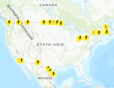
Border crossings of electric transmission lines. Mapping Resources implemented as part of the North American Cooperation on Energy Information (NACEI) between the Department of Energy of the United States of America, the Department of Natural Resources of Canada, and the Ministry of Energy of the United Mexican States. The participating Agencies and Institutions shall not be held liable for improper or incorrect use of the data described and/or contained herein. These data and related graphics, if available, are not legal documents and are not intended to be used as such. The information contained in these data is dynamic and may change over time and may differ from other official information. The Agencies and Institutions participants give no warranty, expressed or implied, as to the accuracy, reliability, or completeness of these data. Parent Collection: [North American Cooperation on Energy Information, Mapping Data](https://open.canada.ca/data/en/dataset/aae6619f-f9f3-435d-bc32-42decd58b674)
-

The Remote Communities Energy Database is a public resource that provides pertinent factual information about the generation and use of electricity and other energy sources for all remote communities in Canada. Communities are identified as remote communities if they are not currently connected to the North-American electrical grid nor to the piped natural gas network; and is a permanent or long-term (5 years or more) settlement with at least 10 dwellings. The Remote Communities Energy Database is the only national data source on energy in remote communities that is publically available on one centralized site. The Remote Communities Energy Database allows users to search and conduct analyses of remote communities and their energy context. Users are also able download the data from the Remote Communities Energy Database dataset in CSV (i.e., excel compatible) format. This data is collected from a number of sources including the remote communities themselves, local utilities, provincial and territorial government’s, Indigenous and Northern Affairs Canada (INAC), Statistics Canada, Natural Resources Canada (NRCan) and various other stakeholders.
-
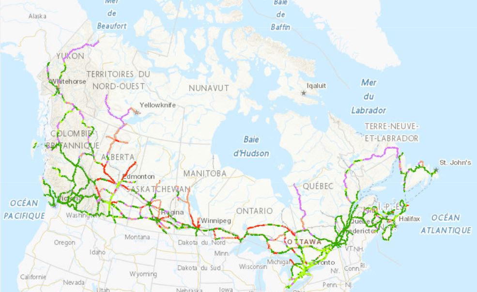
The Zero Emission Vehicle Infrastructure Program (ZEVIP) aims at addressing the lack of charging infrastructure in Canada, one of the key barriers to zero emission vehicle adoption by increasing the availability of localized charging where Canadians live, work, travel and play. This Planning Map for Public EV Charging Infrastructure identifies priority areas and accounts for available charging infrastructure and expected charging needs with a focus on public corridor charging. To optimize web performance when using the map, it is recommended you zoom into the areas you are exploring. Priority areas are identified on a scale ranging from lowest to highest priority. Public Corridor Charging includes the EV charging needs of those travelling longer distances on highways and major roads. The objective is to ensure that EV drivers can travel over the majority of Canada’s road network connecting most communities in an EV without being limited on vehicle range. The map identifies priority locations within 1.6 kilometres of major roads based on criteria such as, traffic, expected EV adoption and distance between chargers
-

In August 2025 the Major Projects Office was launched, with the mandate to advance major projects in Canada and streamline federal regulatory project approval. This dataset was created to provide open access to key information about the projects and transformative strategies that have been referred to the Major Projects Office. This dataset can be layered with other data available on the Open Science and Data Platform. By accessing this data, users can conduct more comprehensive analyses to support evidence-based decision-making and inform regulatory processes including future impact assessments. Please visit the Major Projects Office for more information.