 Arctic SDI catalogue
Energy
Type of resources
Available actions
Topics
Keywords
Contact for the resource
Provided by
Years
Formats
Representation types
Update frequencies
status
Service types
Scale
-

This Web Map Service depicts the location of clean electricity generating facilities by type of clean energy source and power generation capacity. Clean energy sources shown on the map include biomass, hydro, nuclear, solar, tidal and wind. The data comes from the provinces and territories, other federal departments and clean energy associations in Canada. The service is one of many themes mapped in the web mapping application Map of Clean Energy Resources and Projects (CERP) in Canada.
-

This dataset contains spatial indices of environmental and social sensitivities for natural resources development for all of Canada. Both model result rasters (index maps) and input factors (weighted indices) are included along with point file locations of mineral, forestry, renewable energy, and future major projects.
-

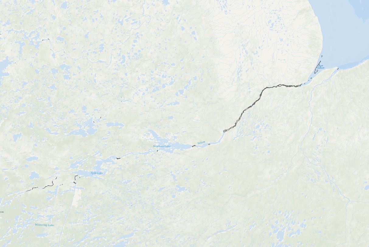
This dataset uses RADARSAT Constellation Mission (RCM) Synthetic Aperture Radar (SAR) satellite images to identify open water regions within ice-covered rivers during winter, with the aim to assess hydrokinetic resources near remote communities reliant on diesel fuel for electricity generation. The data is processed with the HyRASS, a machine learning-based SAR image processing and classification algorithm. Disclaimer: This dataset was designed to identify open water regions within ice-covered rivers for assessing hydrokinetic resources near remote communities reliant on diesel fuel for electricity generation and is subject to the following limitations: • This dataset was derived from RADARSAT Constellation Mission (RCM) Synthetic Aperture Radar (SAR) satellite images. While these images are generally reliable, they are subject to inherent limitations, including resolution constraints, potential distortion, and occasional inaccuracies in real-time conditions capture. • The HyRASS algorithm is designed to pinpoint open water areas using satellite images, with a particular emphasis on RCM quad polarization (QP) imagery. This specialization means that its effectiveness depends on the accessibility of this specific type of imagery. Consequently, the data it produces might not cover a broad spectrum of time periods. For more reliable results, it's essential to classify areas more regularly, ensuring that detected open water regions are consistent over time. This dataset is intended for preliminary assessment and should not be the sole basis for making critical decisions or investments related to hydrokinetic energy projects. Further validation and in-depth analysis are strongly recommended, and users should conduct their own due diligence and additional research to verify the data accuracy and relevance for specific applications. By accessing and using this dataset, users acknowledge and accept these disclaimers. The providers of this dataset explicitly absolve themselves of any responsibility or liability for any consequences arising from the use, reliance upon, or interpretation of this dataset. Users are advised that their use of the dataset is at their own risk, and they assume full responsibility for any actions or decisions made based on the information contained therein. This disclaimer is in accordance with applicable laws and regulations, and by accessing or utilizing the dataset, users agree to release the providers of this dataset from any legal claims, damages, or liabilities that may arise from such use.
-

Natural gas onshore facilities used to receive, unload, load, store, gasify, liquefy, process and transport by ship, natural gas that is imported from a foreign country, exported to a foreign country, or interior commerce. Mapping Resources implemented as part of the North American Cooperation on Energy Information (NACEI) between the Department of Energy of the United States of America, the Department of Natural Resources of Canada, and the Ministry of Energy of the United Mexican States. The participating Agencies and Institutions shall not be held liable for improper or incorrect use of the data described and/or contained herein. These data and related graphics, if available, are not legal documents and are not intended to be used as such. The information contained in these data is dynamic and may change over time and may differ from other official information. The Agencies and Institutions participants give no warranty, expressed or implied, as to the accuracy, reliability, or completeness of these data.
-

Sub-surface facilities used for storing natural gas. The facilities are usually hollowed-out salt domes, geological reservoirs (depleted oil or gas field) or water bearing sands (called aquifers) topped by an impermeable cap rock. Mapping Resources implemented as part of the North American Cooperation on Energy Information (NACEI) between the Department of Energy of the United States of America, the Department of Natural Resources of Canada, and the Ministry of Energy of the United Mexican States. The participating Agencies and Institutions shall not be held liable for improper or incorrect use of the data described and/or contained herein. These data and related graphics, if available, are not legal documents and are not intended to be used as such. The information contained in these data is dynamic and may change over time and may differ from other official information. The Agencies and Institutions participants give no warranty, expressed or implied, as to the accuracy, reliability, or completeness of these data.
-

Facilities designed to recover natural gas liquids from a stream of natural gas. These facilities control the quality of the natural gas to be marketed. Mapping Resources implemented as part of the North American Cooperation on Energy Information (NACEI) between the Department of Energy of the United States of America, the Department of Natural Resources of Canada, and the Ministry of Energy of the United Mexican States. The participating Agencies and Institutions shall not be held liable for improper or incorrect use of the data described and/or contained herein. These data and related graphics, if available, are not legal documents and are not intended to be used as such. The information contained in these data is dynamic and may change over time and may differ from other official information. The Agencies and Institutions participants give no warranty, expressed or implied, as to the accuracy, reliability, or completeness of these data. Parent Collection: [North American Cooperation on Energy Information, Mapping Data](https://open.canada.ca/data/en/dataset/aae6619f-f9f3-435d-bc32-42decd58b674)
-

This dataset represents the Environmental and Socio-economic Assessments (ESA) submitted to the Canada Energy Regulator (CER). The CER has made this and other ESAs available through an online search tool called BERDI (Biophysical Socio-Economic Regional Data and Information). Data extraction methodology is available on the BERDI website. Pipelines represented in this layer include a start and end point.
-
Building on the initial effort (“Database of Open Water Areas in River Ice for Provinces of Manitoba, Ontario, Quebec, and the Maritimes - Potential Locations For River Hydrokinetic Energy Extraction Identified Through Optical Satellite Imager”; weblink: https://search.open.canada.ca/openmap/d9823004-29aa-40e2-aa47-9c54cf88c309), a follow-up research project has led to the publication of this extensive analysis encompassing the entirety of Canada’s major freezing rivers. This work has applied advanced image processing and classification algorithms to the selected images, elevating the classification and analysis to a higher level of accuracy and providing a more comprehensive dataset for exploring river hydrokinetic energy prospects across the country. This dataset identifies open water areas within ice-covered major Canadian rivers, aiming to evaluate potential hydrokinetic resources. The data is derived from high-resolution optical satellite imagery obtained from Landsat and Sentinel satellites corresponding to National Research Council (NRC) 2014 flow data of river reaches with water depths of at least 10 meters and a flow velocity of a minimum of 0.5 meters per second. Using advanced image processing and machine learning algorithms, the dataset efficiently differentiates between ice-covered and open water regions, providing a reliable basis for assessing hydrokinetic energy potential in the identified areas. Disclaimer: This dataset is subject to the following limitations: • Landsat and Sentinel optical satellite images are high-resolution, but they may contain resolution errors, possible distortions, and inaccuracies in depicting on-ground conditions. • Despite advanced image processing and machine learning algorithms, errors or biases may exist. • The dataset's reliability is also influenced by the NRC flow data. Therefore, users should view this dataset as a preliminary assessment tool, not a definitive guide for decision-making or investment in hydrokinetic projects. It is strongly recommended to validate its accuracy and suitability for specific applications through additional research and studies. By accessing and using this dataset, users acknowledge and accept these disclaimers. The providers of this dataset explicitly absolve themselves of any responsibility or liability for any consequences arising from the use, reliance upon, or interpretation of this dataset. Users are advised that their use of the dataset is at their own risk, and they assume full responsibility for any actions or decisions made based on the information contained therein. This disclaimer is in accordance with applicable laws and regulations, and by accessing or utilizing the dataset, users agree to release the providers of this dataset from any legal claims, damages, or liabilities that may arise from such use.
-

The Remote Communities Energy Database (RCED) is a tool that aims to collect and show pertinent information about the generation and use of electricity and other energy sources for all remote communities of Canada. This data is collected from a variety sources, including Statistics Canada, Provincial and Territorial Governments, utilities, public reports and communities. The term “remote community” refers to any community not currently connected to the North American electrical grid nor to the piped natural gas network; and which is a permanent or long-term (five years or more) settlement with at least 10 dwellings. Disclaimer: Natural Resources Canada (NRCan) accepts no responsibility or liability for any errors, inaccuracies and/or omissions in the Remote Communities Energy Database (RCED). The content of the RCED is a compilation of data obtained from many sources and the data is subject to change without notice. Neither does NRCan warrant or guarantee that the information is accurate, complete or current at all times. In no event will NRCan or the Government of Canada and its employees be liable or responsible for any damages resulting from any such errors, inaccuracies or omissions nor will they be liable or responsible for any lost profits, loss of revenue or earnings, claims by third parties or for any economic, indirect, special, incidental, consequential or exemplary damage including but not limited to any demands or causes of action in contract, tort or otherwise including any liability for negligence.
-
Border crossings of liquids pipelines. Mapping Resources implemented as part of the North American Cooperation on Energy Information (NACEI) between the Department of Energy of the United States of America, the Department of Natural Resources of Canada, and the Ministry of Energy of the United Mexican States. The participating Agencies and Institutions shall not be held liable for improper or incorrect use of the data described and/or contained herein. These data and related graphics, if available, are not legal documents and are not intended to be used as such. The information contained in these data is dynamic and may change over time and may differ from other official information. The Agencies and Institutions participants give no warranty, expressed or implied, as to the accuracy, reliability, or completeness of these data. Parent Collection: [North American Cooperation on Energy Information, Mapping Data](https://open.canada.ca/data/en/dataset/aae6619f-f9f3-435d-bc32-42decd58b674)